Winter weather on Folly? SNOpe.

Well, last night was certainly interesting, if nothing else, as false alarms from weather apps and a questionable view from a webcam stirred Charleston into a brief snow frenzy that ultimately did not pan out.
The setup

While the sensible weather yesterday was pretty tame, the meteorology of what was happening was actually quite interesting. A strong mid-level disturbance was swinging through the area throughout the day. Thanks to sparse moisture, the only evidence of this we saw was some increased cloud cover.
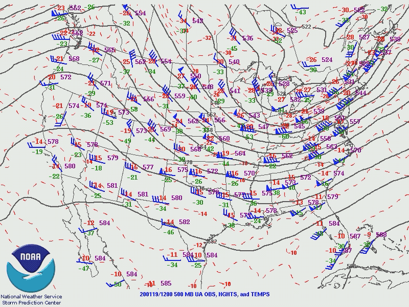
Further out into the ocean, the energy that helped spawn this disturbance coincided with a favorable area of jet stream divergence aloft, promoting the development of a surface low off the Florida coast.

Said surface low was responsible for keeping winds rather elevated in the Charleston area yesterday, with gusts to 30 MPH at times as we sat in the area between high pressure to the west and the strengthening low to the southeast.
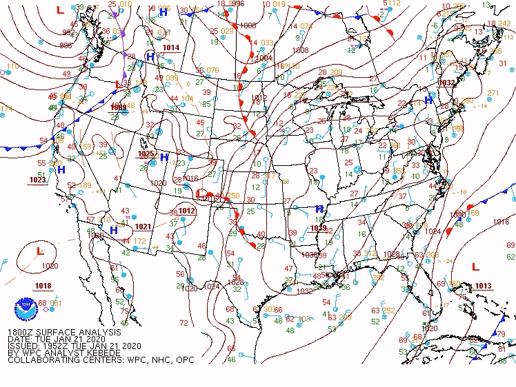
As the surface low developed further, a frontal boundary set up off the SC and NC coasts. The flow around the surface and mid-level lows started to wrap some elevated moisture toward the coast. This moisture showed up as light radar returns over the ocean starting around 5 PM. By 7-8 PM, these returns started creeping closer to the coast. Then, the fun began.
The apps take notice

As radar reflectivity began to creep closer to the coast, some automated weather apps began to start getting a little unnecessarily excited around the potential for frozen precipitation. With surface temperatures in the mid-30s and freezing levels under 1400 feet, all we would really need for a few flakes would be ample moisture and lift. Based on the radar returns, it certainly seemed the lift was there, but the moisture was always the question.

Looking at the evening weather balloon from the National Weather Service office in Charleston, we see the low freezing level (1,361 feet to be precise), a snow growth layer between 10,465 feet and 12,519 feet, and a whole lot of dry air. There was very little moisture in the atmosphere to wring out, and it is a credit to the strength of the developing storm system that it could wring any out at all. The dry air closest to the surface is the key component, as the depth and strength of that layer implies that precipitation would not survive to the surface.
It’s worth noting that radar beams increase in altitude with distance from the radar site. Near Charleston, we typically see about 4,500-5,000 feet up at the lowest tilt of the radar. This becomes closer to 8,000-9,000 feet near McClellanville. As a result, the further away from the beam we are, the higher up we’re seeing into the storm.
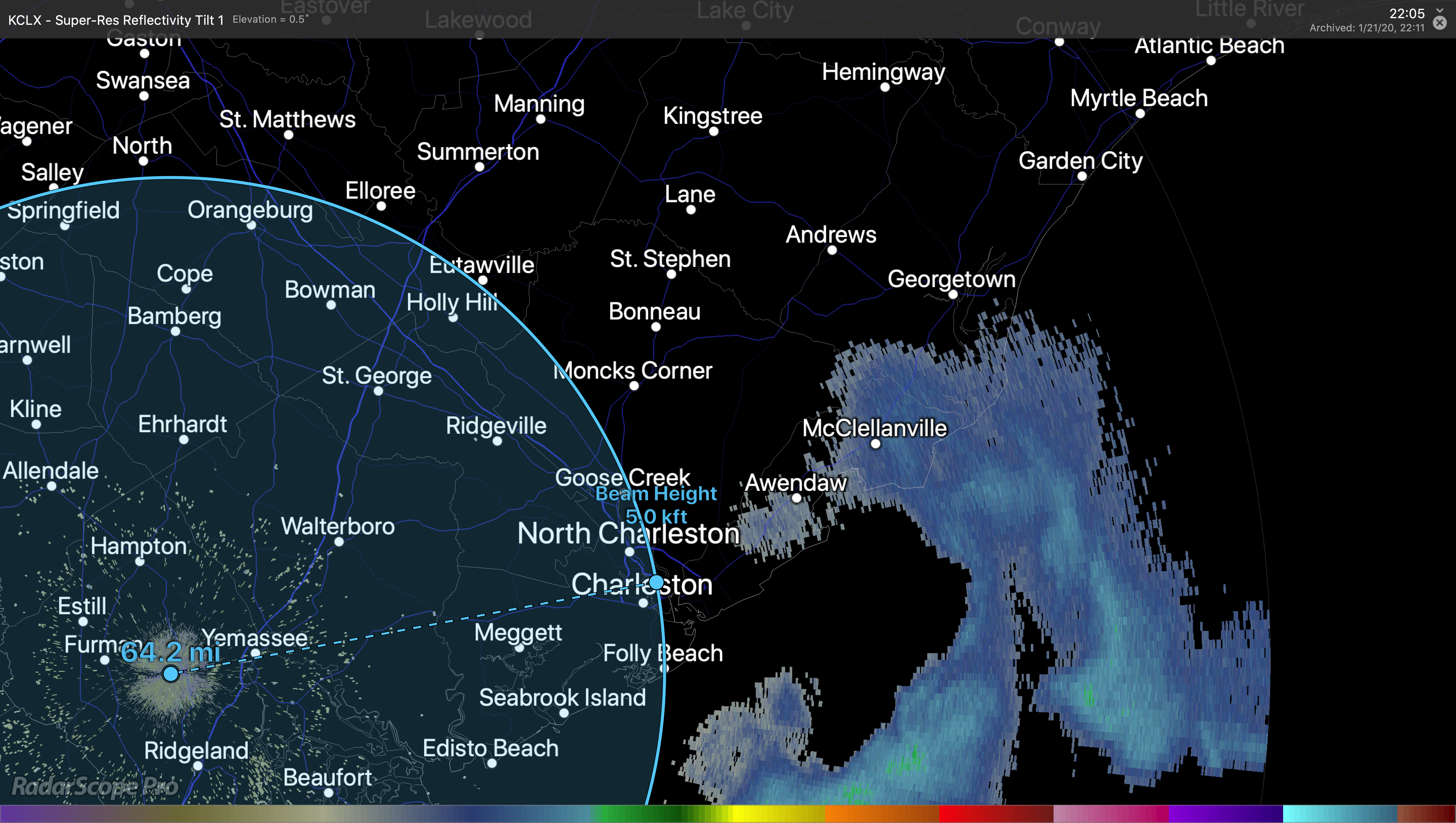
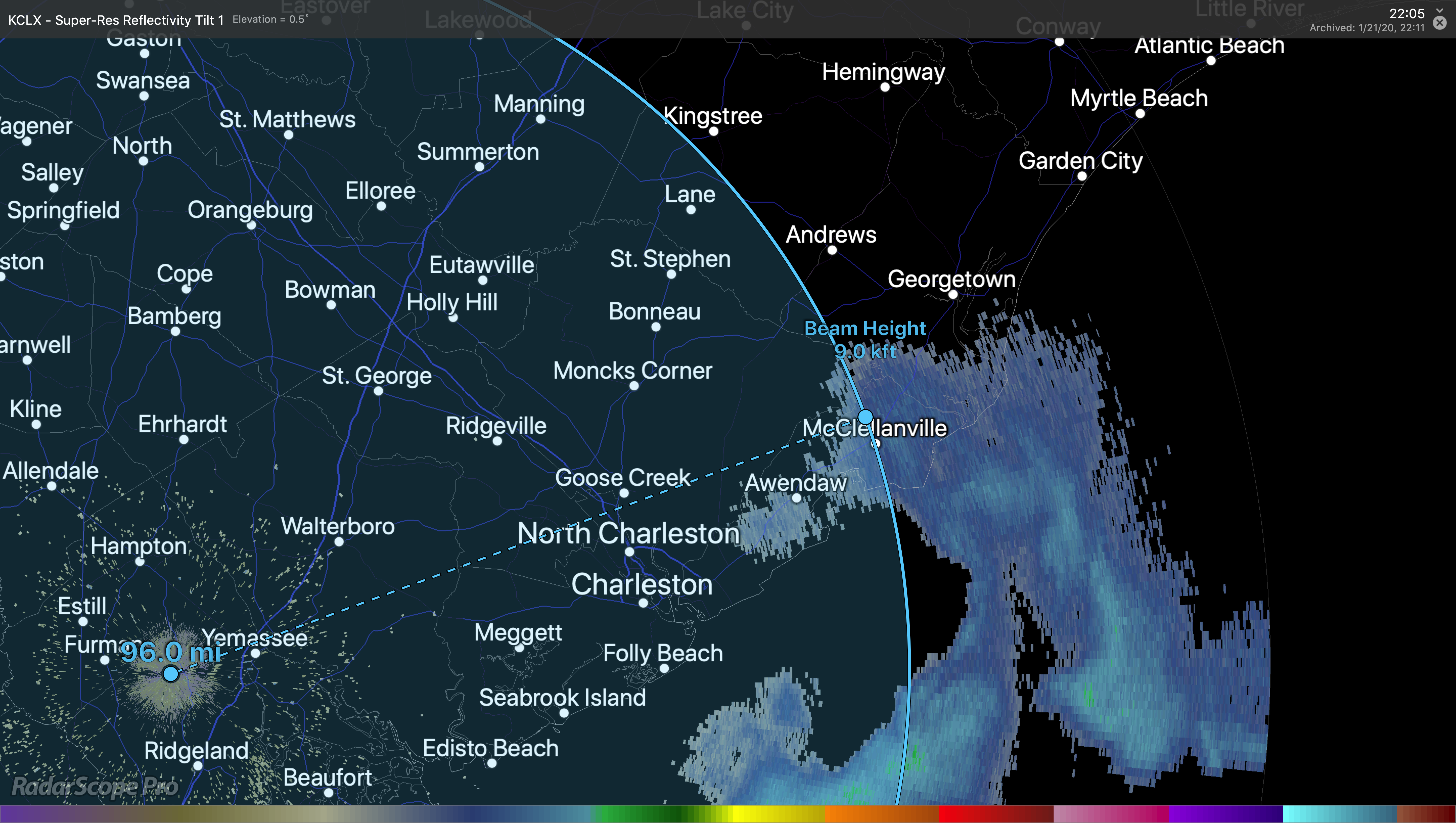
So, while radar returns were negligible around 5,000 feet, we did ping on some activity over McClellanville which is closer to 9,000 feet — but this is as low as we can see from the Charleston radar here.
But if we look at the animation from earlier, we will see that as the radar echoes moved closer to the radar beam, they began to disappear. This strongly implies evaporation or even sublimation (a phase change directly from solid to gas). With surface dewpoints 10-12° and a dry layer several thousand feet deep, it is highly unlikely that any precipitation would have made it to the ground. The National Weather Service emphasized this point in its Area Forecast Discussion:
That didn’t stop the weather apps from popping off, though.
AccuWeather was the first to jump on the snow train, but the default iPhone weather app quickly followed, and The Weather Channel’s app pushed “Snow Alerts” a little later on.
This, naturally, sparked a lot of conversation. Snow Twitter is serious business around these parts, and many people checked their apps to find that pesky little snowflake that seems to cause drama at least once a winter.
Meteorologists worked quickly to debunk the snow potential, noting the dry layer on the weather balloon which was eating up the moisture as it fell.
Then, someone pulled up the Folly camera, and things got weird.
“It’s snowing on Folly!”
SurfChex operates a camera at the Tides at Folly Beach. As I understand it, chatter began to grow on Facebook in the one of the Folly Beach community groups that this camera was showing snow in progress. This then began to spread on Twitter, and even made it all the way to Charlotte’s Brad Panovich, who recorded the video above.
Meteorologically, it was exceptionally unlikely that snow was falling at Folly. There were a couple isolated reports of a flurry or two, but radar evidence was scant around this time. Without a measurement of the particles to be sure, it is just hard to say what was what.
More convincingly, two CofC meteorology students and a former director in Charleston’s broadcast media confirmed it: No snow, despite what was on the webcam.
With winds blowing hard out of the north, it is conceivable that sand and other particles were being whipped up. With the camera in night mode, it may have looked like snowfall to some. But, even as clouds cleared out and precipitation aloft departed, the “snow” was still showing up on the camera.
We may never know exactly what went down
The funny thing is that we may never know definitively whether snow did not fall. Radar returns near McClellanville had brightened up a bit for a time in the 10-11 PM timeframe, and there was a report of some flurries then.
One of the SCDOT traffic cams on Isle of Palms also picked up on what looked like a few flurries, but without direct measurement of these targets, we’ll never exactly know for sure whether they were snow or not. That’s perhaps a little unsettling, but it is indeed the way it is.
It isn’t inconceivable that there could have been some flurries, but it would have been highly irregular.
Apps vs. humans

One thing is for certain: The value of human forecasters continues to be borne out. Forecasters at the National Weather Service and across the broadcast spectrum did a good job of dispelling rumors and helping people understand what they were seeing. For better or worse, snow is a serious, disruptive event in the South, and it is crucial to get these forecasts right. Humans that can blend intuition with the science of meteorology will, more often than not, out-forecast a model in many cases.
I have recently started receiving push alerts from weather apps alerting me to precipitation, in part so I know what others are seeing, and I’ve got to tell you that it really is not all that impressive. Looking at the Weather Channel alert above, it is awfully specific about what “will” happen at a very specific time (11:19 PM, you say?), and confers a type of confidence that exceeds the current bounds of the science, especially in such a marginal setup. Since the methodology is proprietary, we will never fully understand what model data drove the decision to alert on snow. And this, my friends, is why the human element remains critical in weather.
Follow my Charleston Weather updates on Mastodon, Instagram, Facebook, Bluesky, or directly in a feed reader. You can also get daily audio updates via the Charleston Weather Daily companion podcast, available wherever fine podcasts are listed. Do you like what you see here? Please consider supporting my independent, hype-averse weather journalism and become a supporter on Patreon for a broader look at all things #chswx!