Thursday: Helene arrives with impacts starting by afternoon
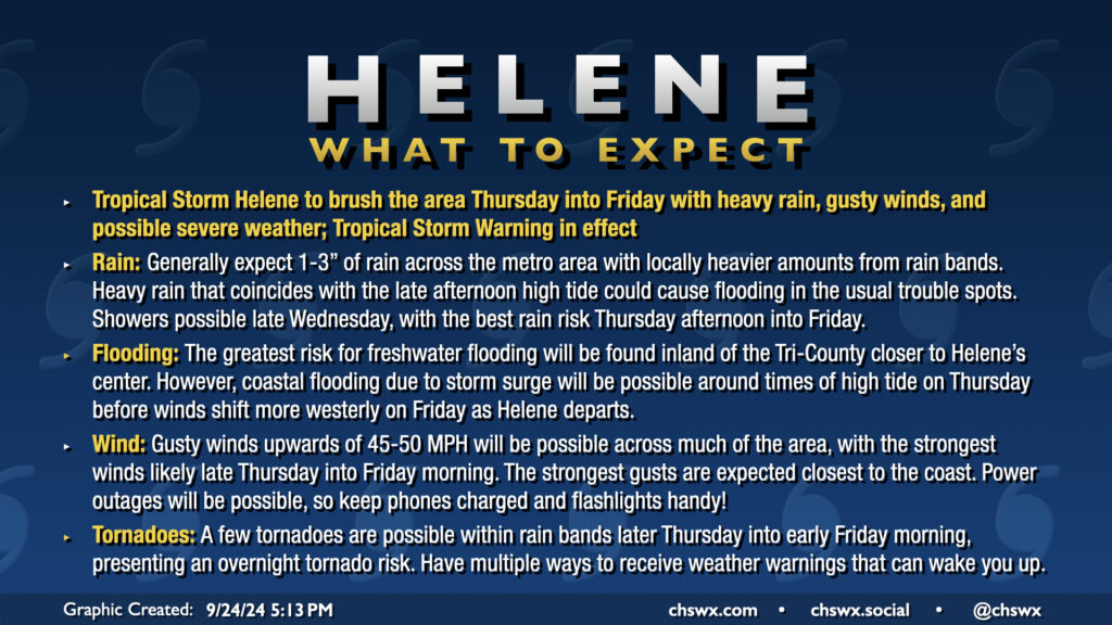
Hurricane Helene’s outer fringes will begin to affect the area on Thursday, with impacts peaking Thursday afternoon through Friday morning. Gusty winds, heavy rain, and a risk for tornadoes are the main concerns. A Tropical Storm Warning is in effect for the Lowcountry, including the entirety of the Charleston Tri-County area.
5PM update: Helene now forecast to reach Category 4 strength
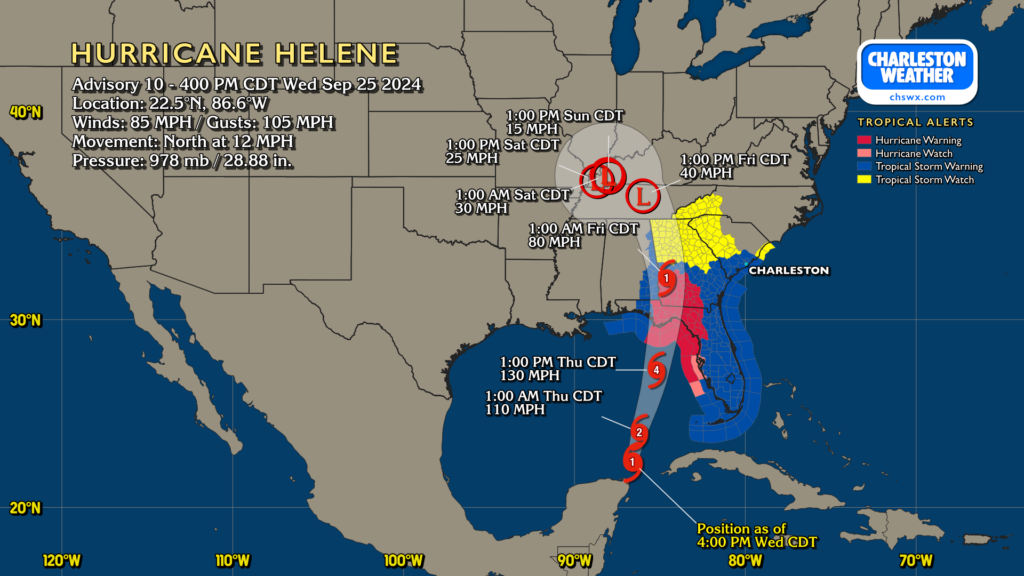
As of the 5PM update, Hurricane Helene was packing maximum sustained winds of 85 MPH and gusts to 105 MPH as it continues to gain strength. The National Hurricane Center is now explicitly forecasting a Category 4 hurricane strike on the Panhandle/Big Bend area of Florida Thursday night. Helene’s wind field will be rather large, and the storm will be moving rather quickly, so it will take a little longer to wind down at first. Hurricane conditions are expected well into southwestern Georgia, with Tropical Storm Watches up into the North Carolina mountains.
Impacts for the Charleston area
Rain & surge
As mentioned last night, we should expect deteriorating conditions on Thursday as rain bands move into the area around Helene’s sprawling circulation. Periods of heavy rain will be possible, but the forward speed of the storm and the general consensus that its heavy rain shield stays to our west will keep our rain totals into the 1-3″ range, highest inland. That’s still a good bit of rain, but (mercifully) is a far cry from what some of us experienced during Debby. Still, periods of flooding cannot be ruled out, especially as we will deal with a bit of surge from this one; minor salt water flooding is expected Thursday afternoon with tides approaching 7.3′ around 4PM. This will have impacts on the usual trouble spots in downtown Charleston.
Tornadoes
The tornado threat continues to be worth watching; modeling continues to show a well-sheared and moderately unstable atmosphere on the east side of the storm throughout the day Thursday and into Thursday night. It may be a long day and night depending on the progression of rain bands, with the tornado threat seeming to kick up by midday and lasting into early Friday morning. Take tonight to check your weather alerting devices to make sure things are working and can wake you up. Remember, tropical tornadoes can develop with little or no warning and tend to move very, very quickly, which is especially dangerous at night. Know where you will go in case of a warning before you have to go — choose an interior room on the lowest floor of your home, putting as many walls between you and the outside as possible.
Winds
Gusty winds will be a factor with Helene, but the core of its strongest winds remain to the west. Still, we could see some gusts pushing 50 MPH at times, especially at the coast and within stronger rain bands. Power outages are possible, so be sure you’re good on your battery-powered items. Disable charge limiters on your phones tomorrow, too — some newer phones let you govern how high you top off the battery for longevity purposes. This is one of those situations where you’ll want to make sure you have the full capacity available to you. Be ready for power to be out for a little while, too, especially if winds come in a little stronger than forecast or a tornado affects your area.
Next update
The next full NHC track and intensity forecast update drops at 11PM. Be sure to check out Carolina Weather Group tonight on YouTube around 9PM, when we expect to convene the panel to discuss Helene and its impacts across the Carolinas.
Follow my Charleston Weather updates on Mastodon, Instagram, Facebook, Bluesky, or directly in a feed reader. Do you like what you see here? Please consider supporting my independent, hype-averse weather journalism and become a supporter on Patreon for a broader look at all things #chswx!