Helene update: Category 4 storm makes its approach to Florida
Category 4 Hurricane Helene continues to push toward a landfall in Florida this evening, intensifying rapidly as it does so. Here at home in the Lowcountry, we have been dealing with a fair bit of rain for much of the day, though the severe weather to this point has avoided the Tri-County. That may run out soon, though, as more rain bands develop and move ashore as we get into tonight and the overnight hours.

Charleston Weather is partnering with the Charleston City Paper to bring you live updates on Helene as the storm impacts the area. Learn more about the partnership.
5PM update: Helene on course for landfall
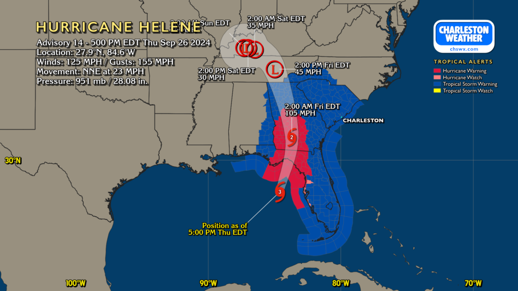
Note: the map above displays information as of the 5PM advisory. An update has been issued that strengthens Helene’s winds to 130 MPH as of 6PM.
Helene is on course for a landfall in the Big Bend area of Florida tonight. It is moving very quickly — NNE at 23 MPH — as it continues to intensify rapidly up to landfall. In fact, lightning is flashing in the eyewall, a sure sign of continued intensification. It will barge across Florida and into Georgia, heading well into the state as a Category 2 storm before winding down Friday afternoon.
The landfall point has shifted a touch eastward today, and that could increase the wind risk locally (more on that in a moment), but otherwise, our impacts generally remain the same.
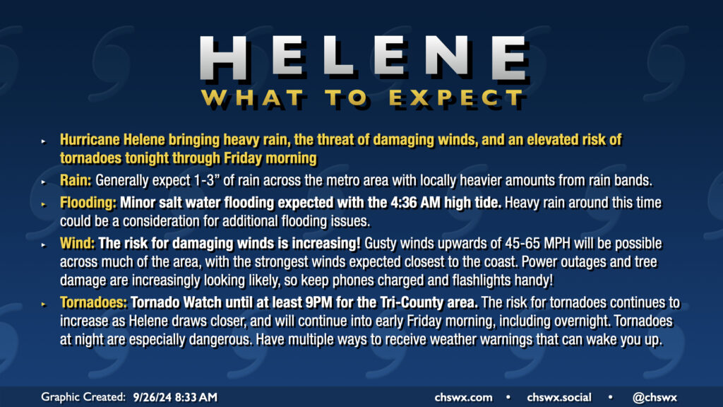
Impacts for the Charleston area as of 6:30 PM
Rain & surge
Off and on rain continues today, but the afternoon high tide fell short of coastal flooding criteria which was awfully nice. However, surge effects should develop overnight, with minor salt water flooding expected around the 4:36 AM high tide early Friday.
Heavy rain will continue off and on, with local amounts of 1-2″ possible in a short time. Otherwise, much of us can expect to get another 1-3″ of rain before it’s all said and done. Any heavy rain downtown could produce flooding in spots, so we will need to continue to monitor this. However, this isn’t the biggest concern. That would be…
Tornadoes
A tornado watch continues until at least 9PM, though I fully expect that to be extended well into overnight. There have been several tornado warnings in South Carolina today, and I expect more as we head into the overnight. The tornado threat still looks to peak after dark. Remember, tropical tornadoes can develop with little or no warning and tend to move very, very quickly, which is especially dangerous at night. Know where you will go in case of a warning before you have to go — choose an interior room on the lowest floor of your home, putting as many walls between you and the outside as possible.
Winds
The risk for strong, damaging winds is increasing. Gusts 45-65 MPH, especially at the coast and within stronger rain bands, could produce tree damage and power outages, some of which may be prolonged. Keep your devices and power banks charged tonight, especially if you rely on them for severe weather warnings. You may very well need to have that full battery capacity at your disposal.
Next update & streaming schedule
The next full NHC track and intensity forecast update drops at 11PM, though at this point, I’m worried less about those updates and more focused on local impacts. I fully expect a long night of severe weather streaming beginning around 7PM on Carolina Weather Group as well, so be sure to tune in as we navigate what could be a busy day and night of severe weather. Please stay safe!
Follow my Charleston Weather updates on Mastodon, Instagram, Facebook, Bluesky, or directly in a feed reader. Do you like what you see here? Please consider supporting my independent, hype-averse weather journalism and become a supporter on Patreon for a broader look at all things #chswx!