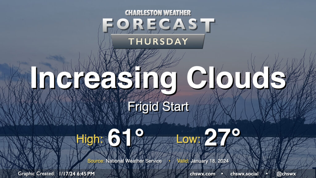
Thursday will get off to a very chilly start across the Lowcountry as calm winds and clear skies combine to allow for a solid radiational freeze across the area tonight into Thursday morning. Expect lows to bottom out in the mid-20s in a fair bit of the metro, with slightly warmer — but still at or very near freezing — temperatures near the coast. Bring pets in tonight and cover sensitive plants. Consider dripping a faucet, too, especially further inland.
The good news is that temperatures won’t stay below freezing for long after the sun comes up. High pressure will move offshore, allowing temperatures to recover to the low 60s by afternoon as cloud cover increases. There is a risk for a few showers very late Thursday into early Friday, but we’ll get the daytime hours in rain-free.
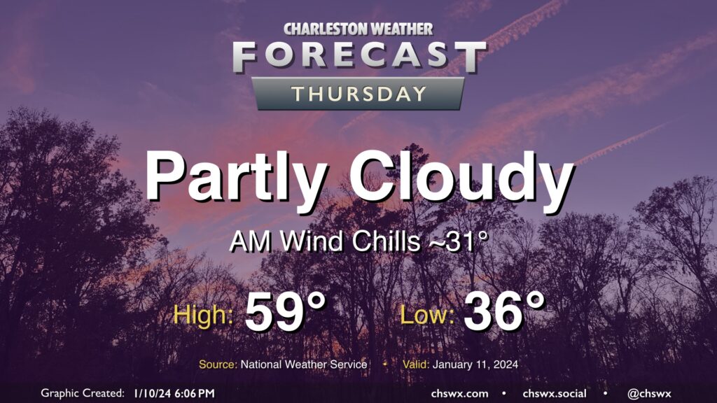
High pressure will be in control for one more day on Thursday. We’ll start the day a little cooler than we did on Wednesday, and certainly much less windy, too. However, a light breeze will still make lows in the mid-30s feel closer to freezing. Temperatures will head to the upper 50s in the afternoon under a mix of sun and cloud cover.
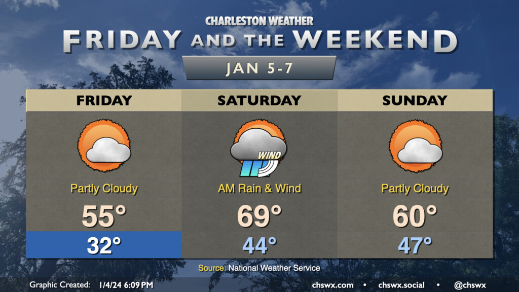
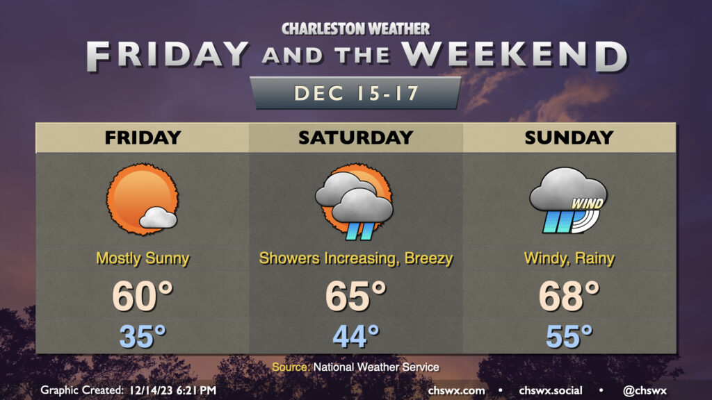
The recent spate of quick-hitting storms continues over the weekend. Friday will get off to a chilly start, with lows around freezing in the metro and likely lower further inland. Highs head to the mid-50s under mostly sunny to partly cloudy skies. Clouds will be increasing late as a Gulf storm system approaches the area, but we get the vast majority of Friday in rain-free.
Showers look to begin around midnight and will last through Saturday morning. Many spots should see an inch or more of rain, with a few spots pushing 1.5-2″. There will be the risk for a few rumbles of thunder, but no severe weather is expected. Rain should depart by mid-afternoon, so it’s not an all-day washout. Saturday will also be notable for how warm it will be: we start the day in the mid-40s and warm to near 70° in the afternoon as we remain in the warm sector of the storm system, about as warm as we’ve been in 2024’s short time.
The storm system’s cold front swings through late Saturday/early Sunday and yields a quiet end to the weekend. Lows in the mid-to-upper 40s will yield to highs around 60° in the afternoon under partly cloudy skies. Quiet weather continues Monday, though a potent storm system looks to affect the area on Tuesday with strong, gusty winds, heavy rain, and maybe some severe weather — stay tuned.
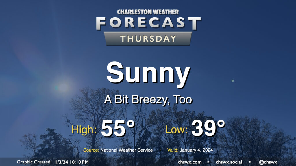
A brief round of rain on Wednesday night will depart the area by daybreak Thursday, leaving behind a little bit cooler air as well as unfettered sunshine. We start the day in the upper 30s to around 40° before warming to the mid-50s in the afternoon — a few degrees below early January normals (60°). It’ll be a little breezy, with winds out of the north and northwest around 10-15 MPH, which will be a contributor to keeping high temperatures below normal despite all the sunshine.
Well, first off, this is not going to be the best weekend of weather ever, especially as we get into Sunday as a now fairly well-discussed nor’easter heads up the coast. So, if you can get some time outside on Friday, do that. It’ll be a chilly start, with lows in the mid-30s and perhaps even a tick or two close to freezing further inland. Temperatures will then warm to around 60° under mostly sunny skies.
There will be a risk for minor coastal flooding with high tide around 9:28am. Water levels should peak just around 7′, and this should be enough to cause a few problems on Lockwood as well as around Fishburne and Hagood. Widespread issues are not expected, though.
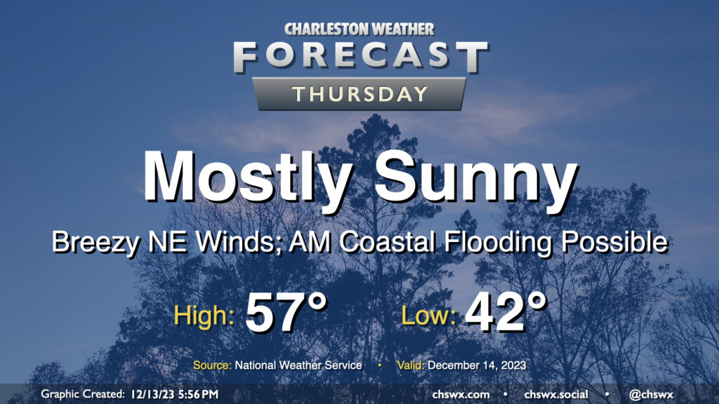
Reinforcing strong high pressure building into the area on Thursday keeps our weather generally cool and quiet, though winds will be blustery and there will be a coastal flooding risk in the morning.
Lows will dip only to the low 40s owing to breezy conditions restricting better radiational cooling. However, cool air pushing in from the northeast will keep highs capped to the upper 50s despite plenty of sunshine. Combine that with an increasingly stiff breeze — 15-20 MPH in the metro, with higher gusts — and you’ll be glad for a jacket with some wind-breaking capability. At least the sun will be out, and the sky should be largely unmarred by any cloud cover.
High tide around 8:37am will get high enough for minor to perhaps moderate coastal flooding smack dab in the middle of the commute. Be ready for possible road closures if downtown is in your commute plans. I’d also be cautious around Long Point Road near Snee Farm as water levels could approach thresholds to flood that road as well. Coastal flooding will remain a concern for the next few mornings, especially as we get into the weekend.
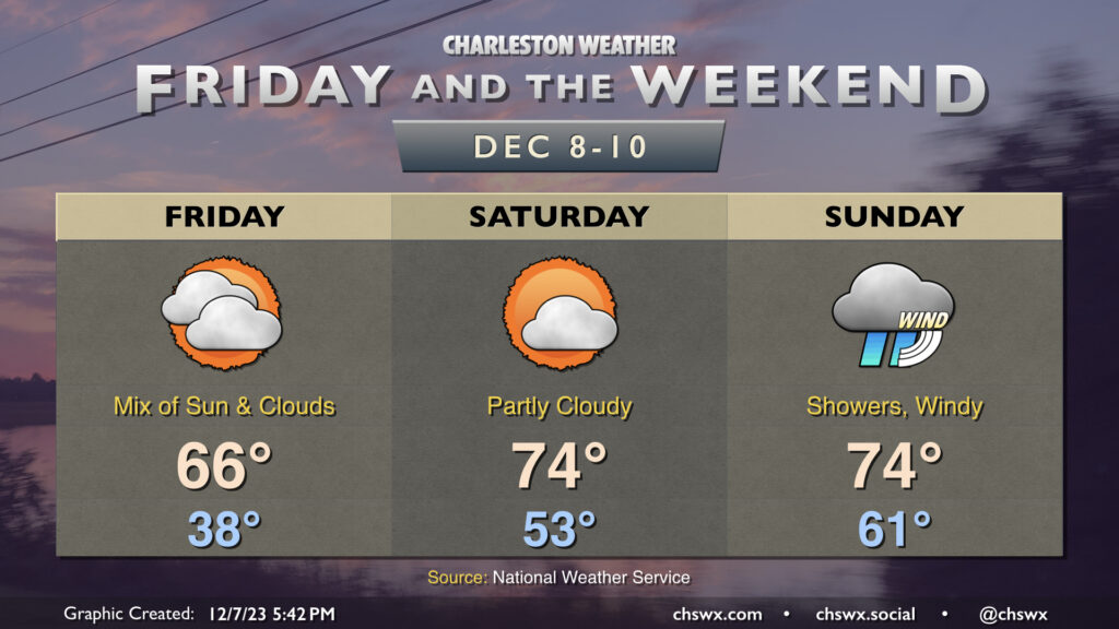
Another round of chilly weather is expected overnight Thursday into Friday. We’ll wake up to temperatures in the upper 30s Friday morning, but high pressure slipping offshore will allow temperatures to warm up to the mid-60s in the afternoon under a mix of sun and clouds. Overall, Friday looks pretty good.
The warming trend continues into the weekend. Saturday is the pick day of the weekend for outdoor activities, and it really isn’t close as a front gets through Sunday. It starts significantly warmer than Friday did, with lows in the low to mid-50s expected. Highs will top out in the mid-70s under generally partly cloudy skies. This will be the last warm and quiet weather day for at least a few days, so try to take advantage!
The weather changes fairly quickly overnight Saturday into Sunday as a strong storm system’s cold front drives toward the area. Sunday gets off to another unseasonably warm start, with lows in the low 60s expected. Showers may be firing off first thing Sunday, but the main band of rain associated with the front looks to arrive later in the afternoon and evening. Wind will be another factor, with gusts upwards of 30 MPH appearing possible at times, even outside of storms. The risk for severe weather is quite low, owing to the minimal available instability that’s expected despite no shortage of bulk wind shear. Still, some thunder is possible, and if additional instability can kick up, a strong to damaging wind gust or two is not out of the question. More fine-tuning of the forecast will occur, but generally speaking, Sunday just doesn’t look promising to be outside.
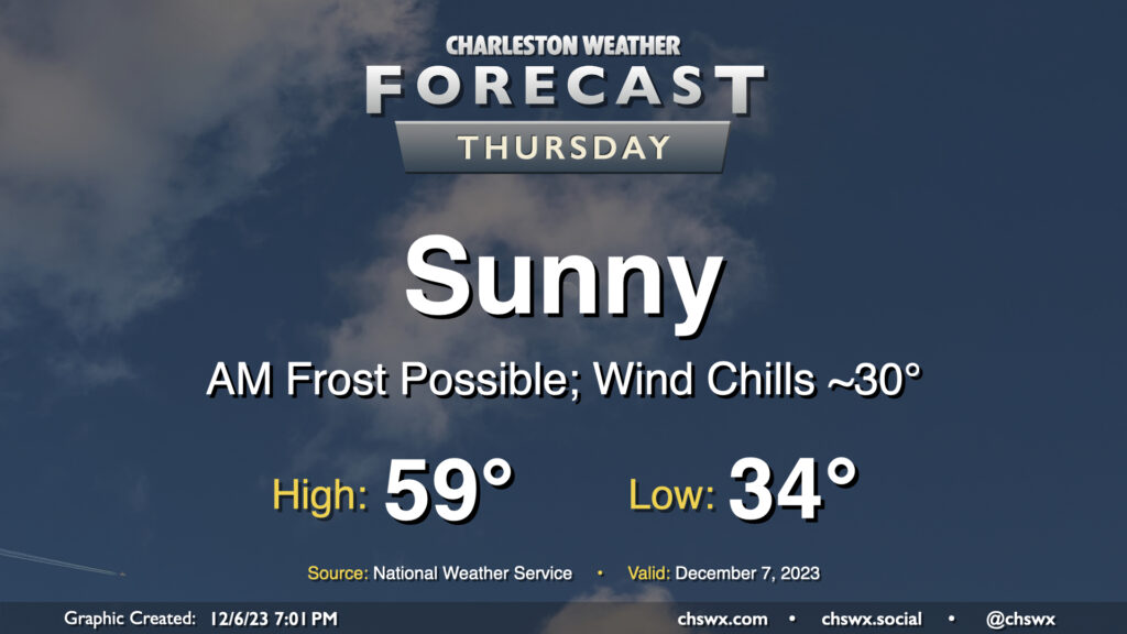
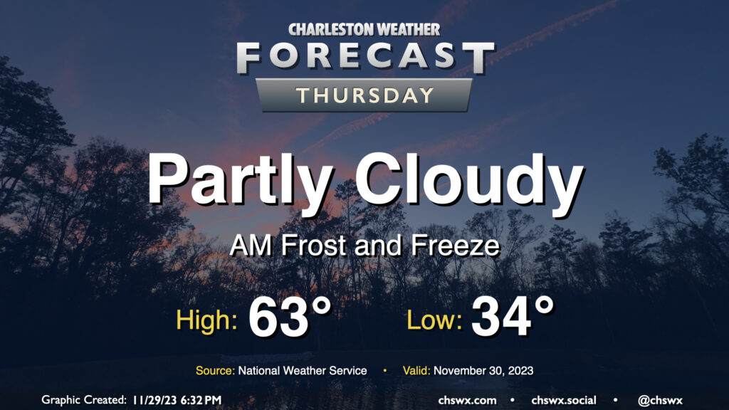
Thursday will represent the bottom-most point of this week’s temperatures rollercoaster, with lows bottoming out in the mid-30s across much of the metro with freezing temperatures further inland. Frost is a distinct possibility, and you’ll want to have pets and plants inside overnight Wednesday. Cool high pressure moves across the area during the day Thursday, limiting highs to the upper 50s to around 60° despite predominantly sunny skies.
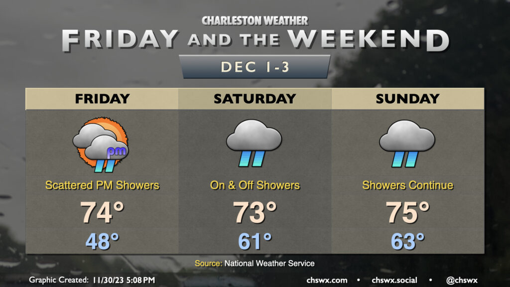
Our recent chilly spell will come to an end on Friday as warmer and more humid air moves back in just in time for the start of meteorological winter (December-February). We start Friday in the upper 40s — well above where we have started the past few mornings — and warm to the mid-70s in the afternoon. Unfortunately, showers will also be returning to the forecast, with isolated to scattered showers developing in the afternoon and increasing in coverage overnight heading into Saturday.
Saturday should feature the greatest shower coverage, with on and off rainfall expected. It’ll still be warm, though — lows start in the low 60s, roughly where our high was on Wednesday — with temperatures heading to the low-to-mid-70s despite the rain in the area. Showers will keep on going into Sunday, though coverage may become a little more sparse as we head into the afternoon and evening hours. That being said, most of the models still have showers going well into Sunday night, so keep the rain gear handy. We’ll run about as warm, if not slightly warmer, than Saturday, with highs running solidly in the mid-70s.
Keep those plants covered or indoors: Frost and freeze conditions will return Wednesday night into Thursday morning as cool high pressure remains in place for one more day. Lows will bottom out in the low to mid-30s in much of the metro, with the warmer temperatures near the water. We could even see some 20s further inland and in more rural locations as well. Make sure your pets have a safe place to be tonight!
Temperatures on Thursday will warm to the low-to-mid-60s in the afternoon under partly cloudy skies, perhaps running a few degrees warmer than Wednesday’s highs, but still on the cool side of normal for late November.