CURRENTLY

67°
Clear
last updated at 9:56 PM on April 28, 2024

Forecast

Forecast for Charleston updated at 10:11 PM on April 28, 2024
  • Overnight Mostly clear. Lows in the upper 50s, except in the lower 60s near the coast. Southeast winds around 5 mph.
  • Monday Sunny. Highs in the lower 80s, except in the upper 70s near the coast. South winds around 5 mph, increasing to 10 to 15 mph in the afternoon.
  • Monday Night Mostly clear. Lows in the mid 60s. South winds 5 to 10 mph.
  • Tuesday Mostly sunny. Highs in the mid 80s, except around 80 near the coast. South winds 10 to 15 mph.
  • Tuesday Night Partly cloudy. A slight chance of showers after midnight. Lows in the mid 60s. South winds 10 to 15 mph. Chance of rain 20 percent.
  • Wednesday Mostly sunny with a slight chance of showers and thunderstorms. Highs in the lower 80s. Chance of rain 20 percent.
  • Wednesday Night Mostly clear. Lows in the mid 60s.
  • Thursday Sunny. Highs in the lower 80s.
  • Thursday Night Mostly clear. Lows in the mid 60s.
  • Friday Sunny. Highs in the lower 80s.
  • Friday Night Mostly clear. Lows in the mid 60s.
  • Saturday Mostly sunny with a slight chance of showers and thunderstorms. Highs in the lower 80s. Chance of rain 20 percent.
  • Saturday Night Partly cloudy with a slight chance of showers and thunderstorms. Lows in the mid 60s. Chance of rain 20 percent.
  • Sunday Mostly sunny with a slight chance of showers and thunderstorms. Highs in the lower 80s. Chance of rain 20 percent.

Charleston Weather Blog

Forecast explanations, atmospheric science, and other cool weather-related stuff for Charleston, SC

The week ahead: Above-normal temperatures as we head into May

/ April 28, 2024 at 5:36 PM

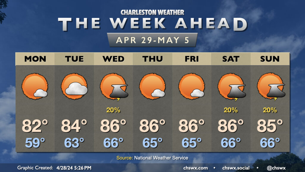
High pressure will be the main weather driver again this week, which will help drive temperatures a few degrees above normal to close out April and bring in May. Monday will be the coolest day of the period with lows in the upper 50s yielding to highs in the low 80s in the afternoon under mostly sunny skies. We warm a little bit on Tuesday with a bit more in the way of cloud cover as well (and maybe a shower or storm well inland). Seabreeze thunderstorms could be in the offing for Wednesday as we get into a stretch of temperatures about 5° or so above normal that’ll last well into the weekend. Quiet weather is expected Thursday and Friday before another disturbance potentially spawns a few isolated thunderstorms on Saturday afternoon as well as into Sunday. No washouts expected, though.

More Posts »