Jared Smith founded @chswx on Twitter in 2008 as an experiment in disseminating weather data through social media. In the ensuing decade-and-a-half, @chswx has provided live coverage of tropical cyclones, tornadoes, severe weather, and even a couple bouts of winter weather to the good people of Charleston, SC.
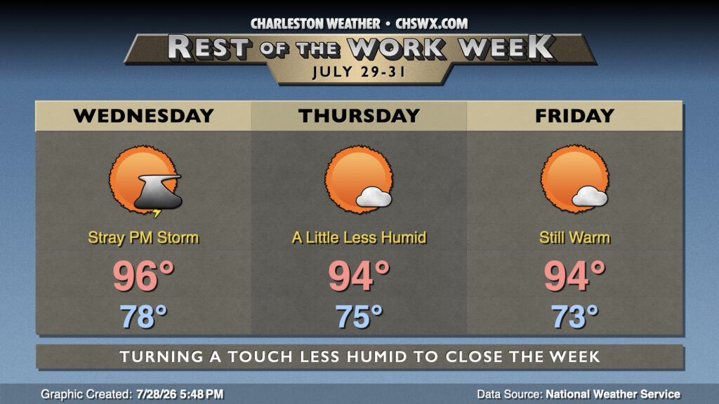
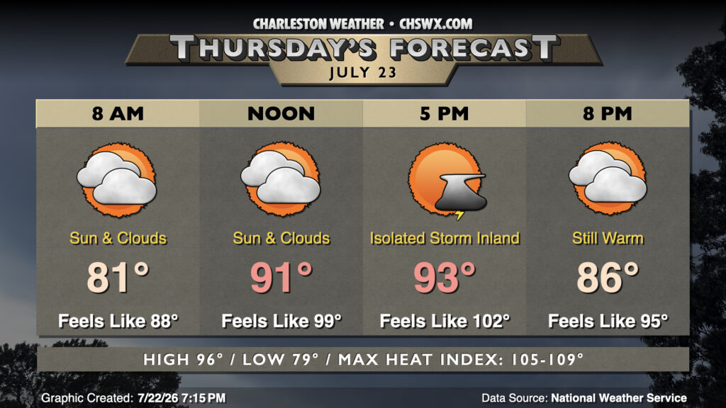
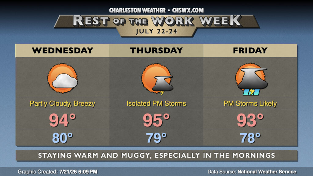
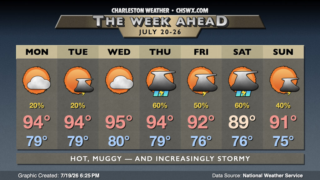
Another hot and humid day awaits for Wednesday, then a bit of drier air filters in to take the edge off the heat ever so slightly to close out the work week and the month of July.
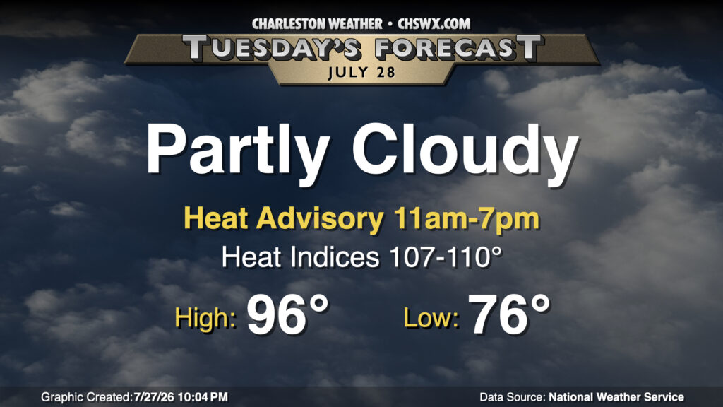
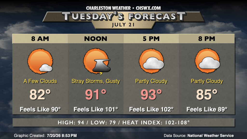
High heat returns to the Lowcountry on Tuesday as southwest winds pump plenty of warm and humid air into the area. We start in the mid-70s inland and upper 70s downtown and at the coast, and with plenty of sunshine, we’ll warm to the mid-to-upper 90s. Dewpoints will run in the mid-70s inland, while they’ll be running in the upper 70s to near 80° at the coast and behind the seabreeze. This will drive heat indices into the upper 100s to low 110s during peak heating, spiking in the wake of the seabreeze as dewpoints surge. A Heat Advisory will go into effect at 11am, and will run through 7pm for the entire Tri-County area. Take frequent water and shade breaks if you’re working outside during the height of the day tomorrow. A stray storm or two can’t be totally ruled out, especially overnight as a front drives southeastward into the Midlands before stalling out.
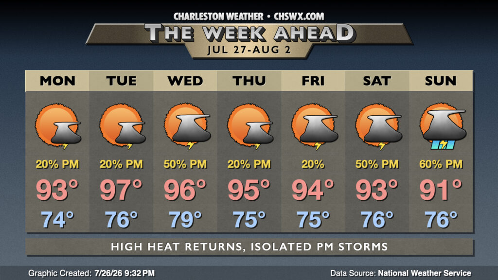
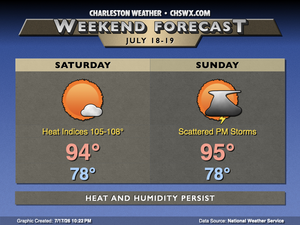
After a very wet weekend that included flooding rains at Mt. Pleasant and Isle of Palms, we should see a bit of a downtrend in rain chances as some of the deeper moisture that’s been hanging around this weekend moves offshore and further into the Atlantic. The pesky cold front that’s been hanging around will start the day just to our south, lifting north during the afternoon, so between this and the seabreeze, it’s still possible for a few afternoon thunderstorms to fire. Temperatures will run in the mid-70s Monday morning, topping out in the low to mid-90s in the afternoon. Heat indices should run around 102-106°, highest near the coast.
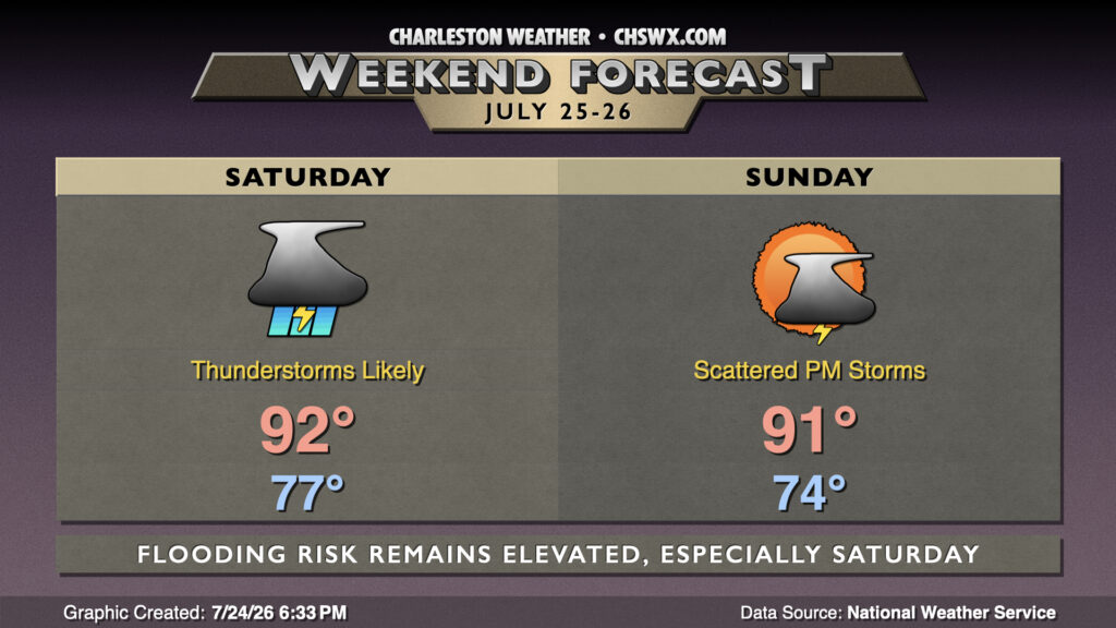
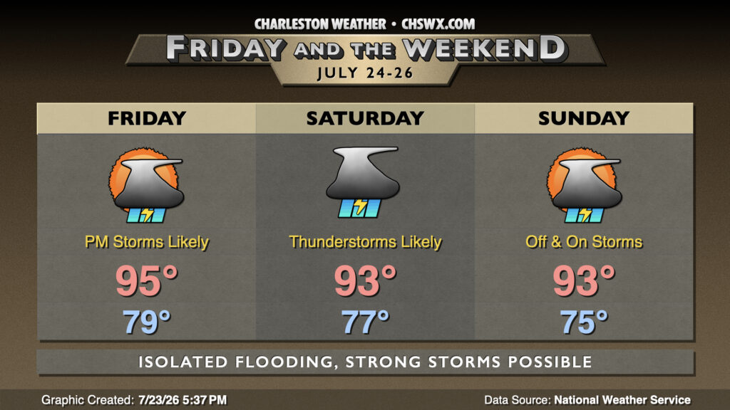
A stalled front will continue to contribute to shower and thunderstorm chances through the weekend, particularly on Saturday as a trough aloft swings through, providing a little extra “oomph” to budding updrafts aspiring to be efficient rain-makers.
A cold front that’s brought quite a bit of rain to North Carolina today will continue to sag southward Friday, stalling out around the area over the weekend and keeping our weather relatively unsettled as a result.
The weather story this week thus far has been the extremely warm and muggy mornings. This morning was no exception — downtown has, thus far, only dropped to 84° while the airport’s low is 80°. If these lows hold, they would break the record warm low temperature downtown and tie it at the airport. These warm lows will continue for the rest of the work week, which will not allow much relief from the mid-90s heat during the day.
Tuesday looks similar to Monday, with temperatures warming into the low-to-mid-90s in the afternoon after another sultry start in the upper 70s to low 80s. Heat indices inland will run in the low 100s, but may push 108° as we get closer to the coast and the higher-dewpoint air. Southerly winds will continue to be breezy, with gusts pushing 30 MPH at times midday.
Midsummer heat and humidity will not relent this weekend with temperatures continuing to run above normal courtesy of Atlantic high pressure pumping warm and moist air into the area while high pressure remains resident aloft for a few more days.