Dorian at 5PM: Dangerous storm continues to lash the Bahamas
At 5PM, Hurricane Dorian was over the Bahamas, packing incredible winds of 185 MPH (with gusts to 220 MPH). It continues an ever-slower westward motion of 5 mph. The storm is expected to nearly stall out on Monday as steering currents weaken, then it is forecast to make a turn to the north sometime late Monday or Tuesday.
The situation with respect to Charleston has not yet changed, and preparations for hurricane conditions on Wednesday and Thursday should be ongoing.
The latest NHC forecast
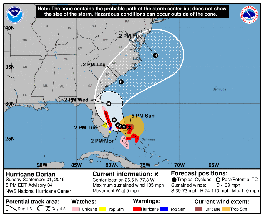
The latest track from the National Hurricane Center continues to indicate the center of Dorian making a very close pass on the Southeast coast, hugging the coastline through Friday. Some weakening is forecast — it won’t be a Category 5 forever, thankfully — but dangerous storm surge, heavy rainfall, and gusty winds still appear likely for Wednesday and Thursday. The degree to which we see these hazards largely depends on the exact track of the storm. Frustratingly, this remains very uncertain. Every scenario between a landfall in Florida to the storm going out to sea remains on the table.
It does appear plausible that major coastal flooding, rip currents, and beach erosion will continue for the next several days. Storm surge may be a significant threat, with some initial projections of 3-6′ of inundation possible (based on the noon NWS briefing). Heavy rainfall, perhaps up to 10″, is a distinct possibility. Winds at least to tropical storm-force (39-73 mph) appear increasingly likely, with hurricane force winds (74+ mph) a possibility especially for coastal communities.
Again, all this is dependent on when and where that northerly turn starts. We just have to watch and wait for the turn. Until then, we only have model guidance to give us a general idea of where it might happen, but a few miles can make a huge difference.
Give proper respect to the uncertainty of the situation by being prepared for the potential for hurricane conditions on Wednesday and Thursday.
What to do tonight and tomorrow
There are some things you should do tonight and tomorrow to get prepared for Dorian as it gets closer to our neck of the woods. I wrote a lot of this for Florence, and I think it applies well for every tropical system.
- Stay informed about the forecast. A lot can change still, and it’s important to stay on top of what’s happening. By the same token, though, you don’t have to watch every single model run. Let the meteorologists synthesize that data into a forecast that you can use to make decisions. Never, ever make decisions based on a single run of computer model guidance!
- Share vetted, reliable information. There’s a lot of “raw material” out there from which forecasts are generated. Much of it looks scary, and much of it may turn out to be wrong. Stick to sharing official Hurricane Center forecasts on social media and refrain from sharing model guidance unless you know how to interpret it and can provide context.
- Refresh your hurricane kit. This isn’t a bad idea this time of year anyway, given that we’re at the peak of the season. Many of you have already gotten started doing this, and that’s good — there will likely be a rush when watches or warnings begin to be issued. Get advice on what to pack in your kit at ready.gov.
- Clean up loose debris, prune back unwieldy branches, etc. You’ve got a good opportunity to get ahead of any potential wind damage by ensuring debris is cleared — essentially reducing the number of possible projectiles. (And if it doesn’t hit, your HOA will be extra-pleased with you. They may even award you Yard of the Month.)
- Ensure your important documents are in a safe place. Birth certificates, marriage licenses, insurance information should be in a fireproof box if at all possible.
- Take photos of your property. If, God forbid, you need to make an insurance claim, this is good documentation to have.
- Learn your evacuation zone. Know your zone — if officials need you to leave, they’ll call your evacuation zone rather than specific geographical landmarks. It’s easy to keep up with evacuation zones and other emergency information using the SCEMD mobile app. (And no, I don’t know if or when evacuations will be issued.)
Next update
The next full track and intensity forecast from the National Hurricane Center will come at 11 PM.
Follow my Charleston Weather updates on Mastodon, Bluesky, Instagram, Facebook, or directly in a feed reader. Do you like what you see here? Please consider supporting my independent, hype-averse weather journalism and become a supporter on Patreon for a broader look at all things #chswx!