The week ahead: Seasonably warm, turning unsettled
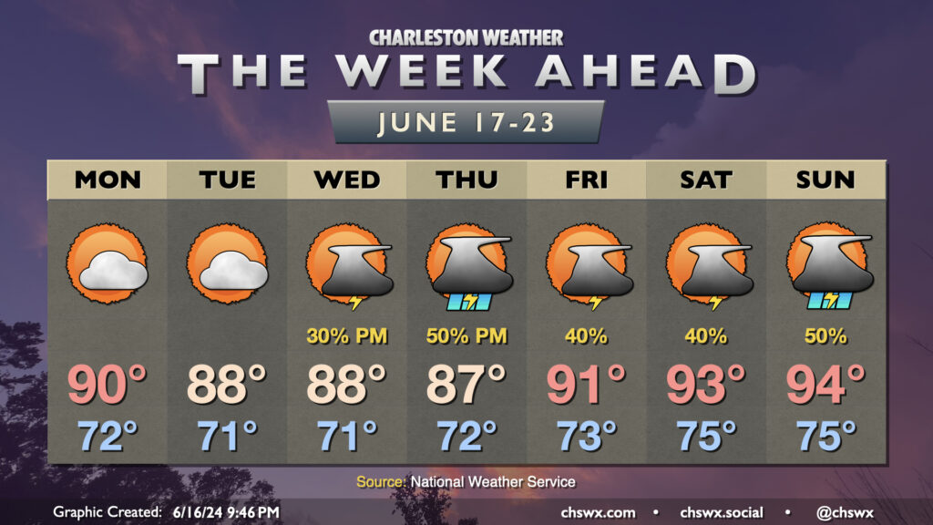
The week ahead will generally feature temperatures around if not even a touch below normal at times through mid-week before warming back up, perhaps into the mid-90s, for the weekend.
We start the week off fairly quietly as a little bit of lower-dewpoint air nudges into the area, generally capping highs in the upper 80s to around 90°. High pressure aloft and at the surface will keep thunderstorm chances very low, so expect to at least get the first couple days of the week in rain-free.
High pressure starts to weaken as we head into Juneteenth, and the standard summertime afternoon thunderstorm chances respond accordingly. Storms could be a little more widespread Thursday as low pressure approaches Florida, enhancing the flow of moisture into our neck of the woods. A warming trend begins Friday as high pressure offshore moves a little further south, turning the resulting flow at the surface more southerly as well and essentially turning the heat pump back on. Low-to-mid-90s temperatures are expected Friday through Sunday, with scattered thunderstorms each afternoon.
Tropical outlook: Bay of Campeche development looking probable; watching area off the FL/GA coast
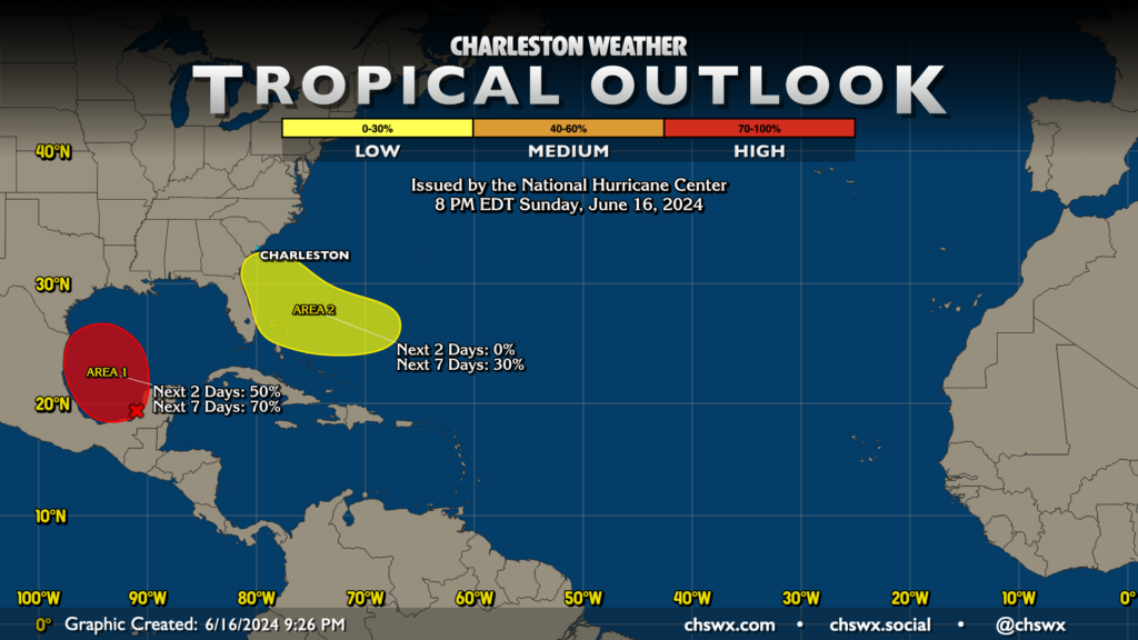
It’s quite probable that the first tropical cyclone of the 2024 Atlantic hurricane season could spin up in the Bay of Campeche this week. The National Hurricane Center gives this area 50% odds of spinning up in the next couple days, with a 70% chance of development over the next week. This will be a moisture enhancer for Texas and Mexico, but probably not much more than that.
The other area to watch is closer to home along yet another stalled front. The GFS spins up a small low pressure system that treks toward Florida and Georgia on Thursday, while the ECMWF keeps it more in open-wave territory. For now, the latter solution is favored, but NHC maintains a 30% chance for it to develop over the next seven days. There’s nothing I’d take my cow down for with this one right now, but we’ll watch it.
The first storm to reach tropical storm strength will be given the name Alberto. Which storm gets it…well, that remains to be seen. Stay tuned.
Follow my Charleston Weather updates on Mastodon, Instagram, Facebook, Bluesky, or directly in a feed reader. You can also get daily audio updates via the Charleston Weather Daily companion podcast, available wherever fine podcasts are listed. Do you like what you see here? Please consider supporting my independent, hype-averse weather journalism and become a supporter on Patreon for a broader look at all things #chswx!