The week ahead: Soggy start cools us off slightly, but heat will return for the Fourth
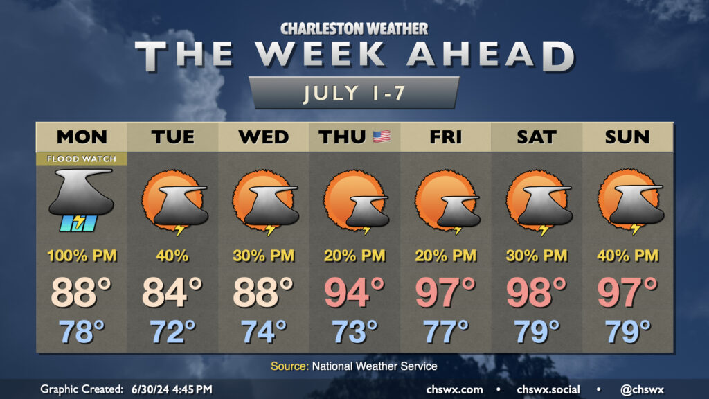
We will get the first week of July off to a very soggy start as a front stalls in the area, bringing a risk for numerous showers and thunderstorms on Monday evening (more on that shortly). While rain chances back off a little bit Tuesday and Wednesday as the front meanders and weakens, we will get at least a brief break from the advisory-level heat that punctuated the end of June. Rain will keep highs to the upper 80s on Monday, while onshore flow Tuesday helps to keep highs tamped down to the mid-80s. Warming begins again Wednesday, though, with upper 80s yielding to mid-90s on the Fourth of July. We’re in the upper 90s for Friday and the weekend with standard afternoon and evening shower and thunderstorm chances expected.
Monday’s flooding threat

Quite a bit of rain is expected to fall along and east of 17-A Monday afternoon and evening as a stalling cold front and seabreeze convection interacts. The latest high-resolution guidance as of this writing continues to be consistent in advertising several hours of showers and thunderstorms, with three-hour totals approaching 1-3″ in many spots. Steering is slow, and we’ll only really get these storms out of here once they gust out. By the time it’s all said and done, it’s a reasonable possibility that a few gauges may have upwards of 5-6″ of rain! On top of all this, high tide peaks around 5:09 PM Monday around 6.4′ MLLW, which is just shy of the flooding action stage in the harbor, so any rain that falls ahead of or during this tide will have significant troubles draining. With all this considered, NWS has hoisted a Flood Watch, starting at noon and running through 9PM.
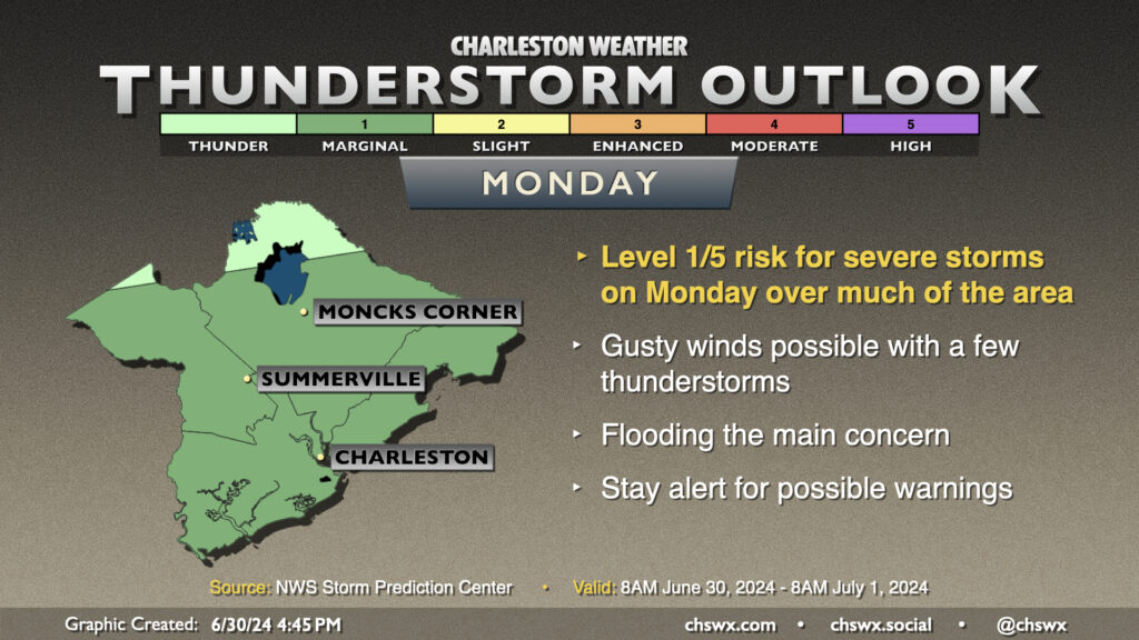
A few thunderstorms on Monday could also become strong to severe with damaging wind gusts the main concern, primarily from wet microbursts given how water-loaded the atmosphere is going to be. However, the risk for severe weather will remain somewhat dwarfed by the more widespread flooding threat. Still, keep an ear out for possible severe weather warnings for wind damage.
Tropics: Dangerous Beryl approaches the Windward Islands, TD Three forms, another depression probable this week
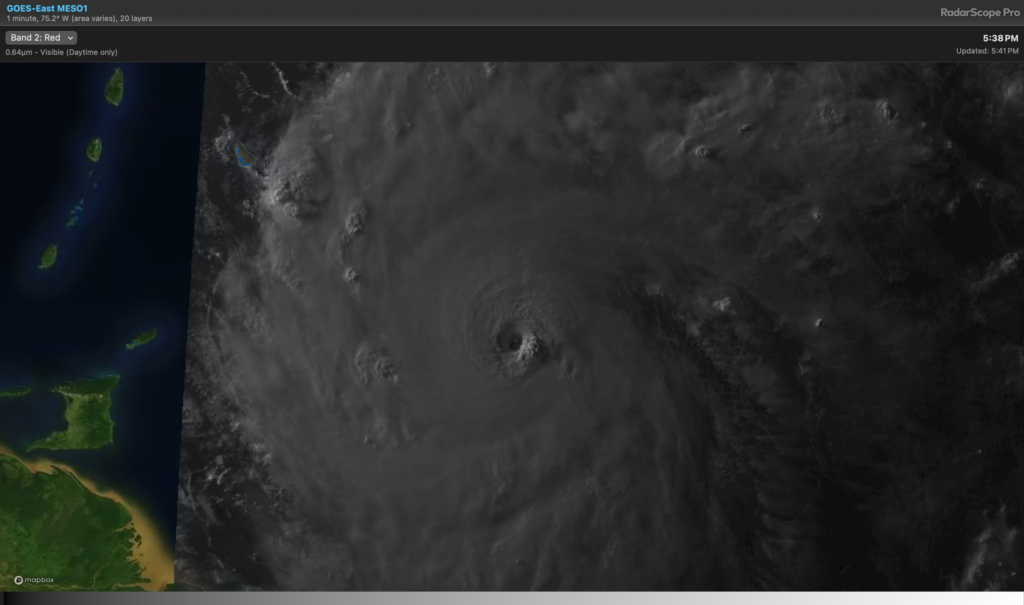
Major Hurricane Beryl is proving to be a formidable threat to the Windward Islands on Monday. As of 8PM, it was a Category 4 storm with maximum winds of 130 MPH, moving WNW at 18 MPH. It is quite notable for being the third earliest major hurricane on record, as well as being the furthest-east major hurricane in the Atlantic basin in June.
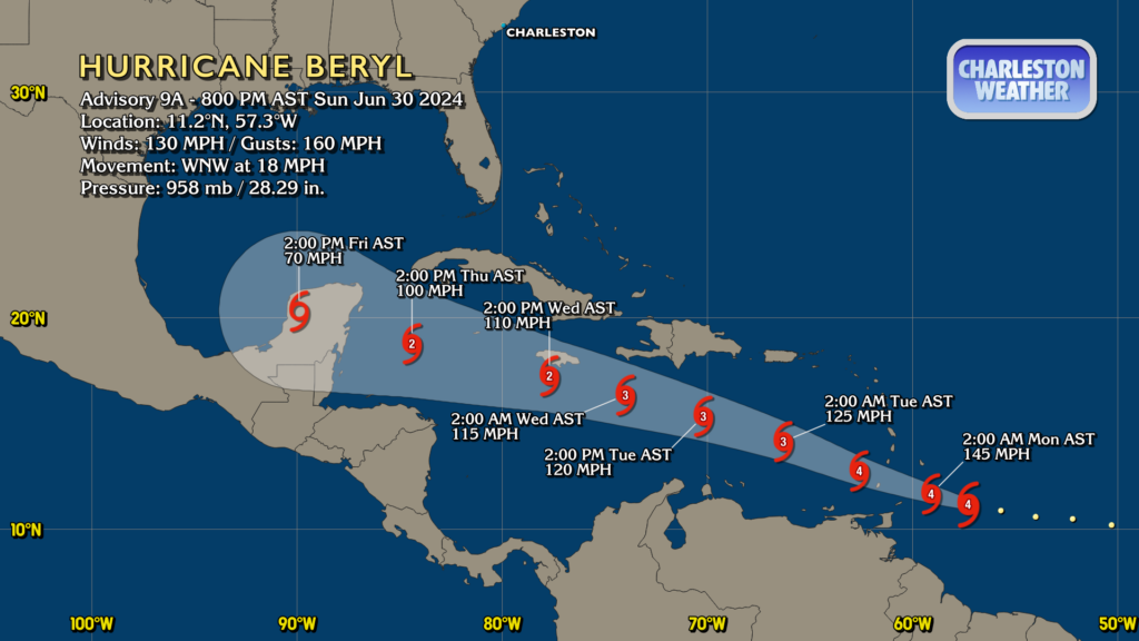
Beryl’s track takes it through the Windward Islands tonight into Monday, heading into the Caribbean on a gradual weakening trend before running into the Yucatan Peninsula late Thursday/early Friday. From there, it will go into the Gulf, but where it goes after that is anybody’s guess. Beryl does not pose any risk to our weather here at home, though.

In addition to Beryl, we briefly have Tropical Depression Three in the Bay of Campeche. This is going to be a heavy rain issue for parts of Mexico, but won’t have an impact on our weather here at home. If it should briefly become named, the next name on the list is Chris.
Tropical outlook: Another depression this week?
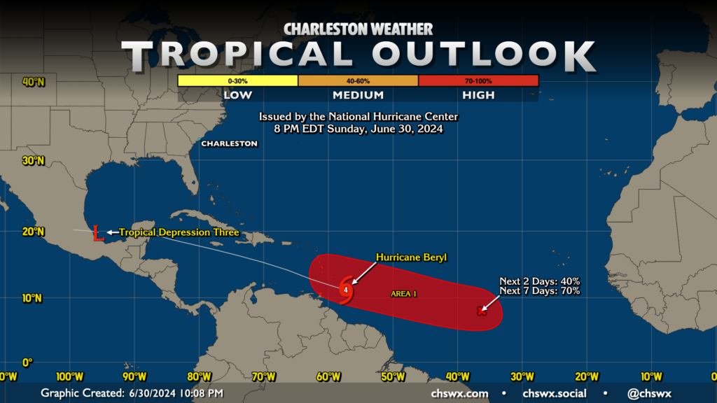
Another system may develop hot on Beryl’s heels this week and follow much the same path. It has a 40% chance of becoming a tropical cyclone in the next couple days, and has a high probability (70% chance) to become one within the week. This certainly would not be good news for the Windward Islands on the heels of what looks to be a significant strike from Beryl. As for us, it’s purely wait and see at this point. What’s remarkable, again, is how far east these storms are forming. With that in mind, August and September looks to the tropical map are what you get when the waters are August and September warm.
Follow my Charleston Weather updates on Mastodon, Instagram, Facebook, Bluesky, or directly in a feed reader. You can also get daily audio updates via the Charleston Weather Daily companion podcast, available wherever fine podcasts are listed. Do you like what you see here? Please consider supporting my independent, hype-averse weather journalism and become a supporter on Patreon for a broader look at all things #chswx!