Tuesday: Not quite as hot, a stray shower or storm possible
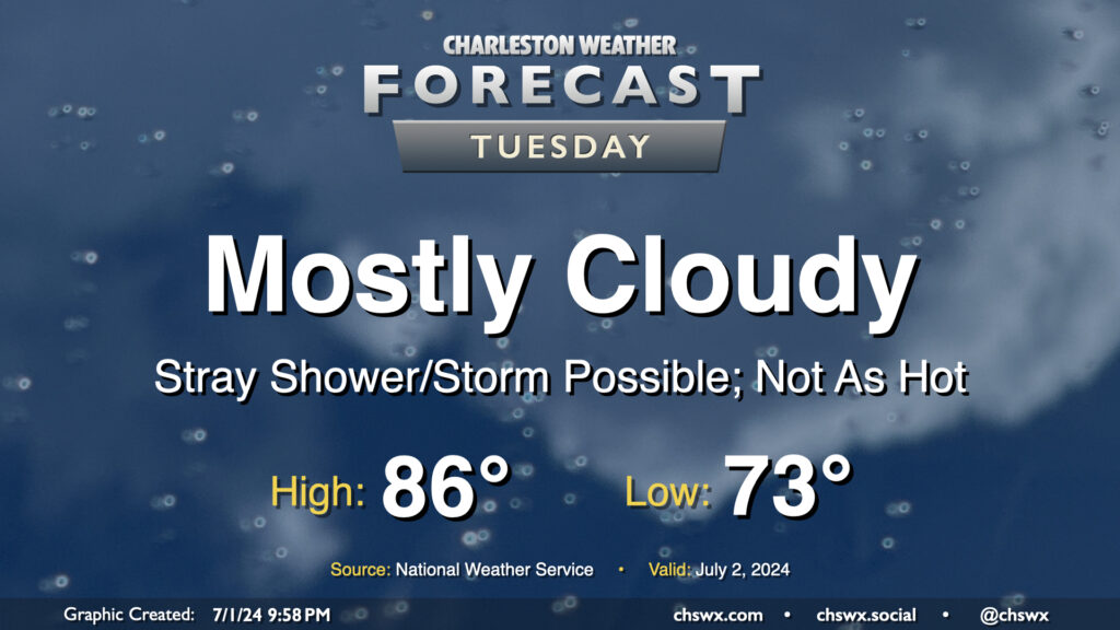
We get a brief reprieve from the heat on Tuesday as the front that brought today’s deluge nudges just south enough for a little bit of cooler and drier air to work in, especially further inland. Mostly cloudy skies will be the rule as onshore flow persists throughout the day. We start the day in the low 70s, but dewpoints sneaking briefly back into the upper 60s could feel a little bit better than we’ve felt. Those dewpoints will start to creep back up, but the cloud cover and onshore flow keeps highs capped to the mid-80s. A stray storm can’t be totally ruled out near the coast; in fact some model data suggests a few downpours will be possible before sunrise. Wait and see on that, but most of us should get Tuesday in rain-free.
Rest of the week: Heat turns up in time for the Fourth
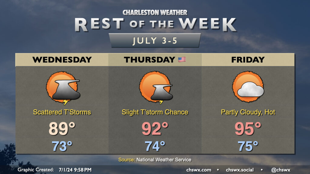
Unfortunately, the heat reprieve is relatively brief. The front will wash out as Wednesday goes on, so while winds will still be largely onshore, temperatures will not be quite as pinned down — we’ll get close to 90° — and dewpoints will head back into the mid-70s. A few showers and thunderstorms will be possible throughout the day into the afternoon before waning in the evening.
We’re solidly back in the 90s for the Fourth of July as an expansive ridge of high pressure builds in aloft. Lows start in the mid-70s, and we warm to the low 90s in the afternoon with just a slight chance of a thunderstorm in the afternoon. Heat indices return to the low 100s, but we do look to stay well short of Heat Advisory levels. Still, be sure you’re applying sunscreen regularly and getting plenty of water if you’re going to be outside for any prolonged period.
The ridge strengthens further Friday, and temperatures respond in kind. We’ll hit the mid-90s in the afternoon after a mid-70s start, and it’s highly unlikely that any storms will be able to get going in the afternoon due to the strength of the ridge. Unfortunately, heat indices could border on Heat Advisory levels again (the break was nice while it lasted), so be sure to take heat precautions once again.
As we get into the weekend, moisture increases, improving the risk for a few afternoon thunderstorms. Unfortunately, we get even hotter and more humid, and heat indices could become particularly heinous (112°+), which means we’ll need to keep going with heat precautions well into next week.
Follow my Charleston Weather updates on Mastodon, Instagram, Facebook, Bluesky, or directly in a feed reader. You can also get daily audio updates via the Charleston Weather Daily companion podcast, available wherever fine podcasts are listed. Do you like what you see here? Please consider supporting my independent, hype-averse weather journalism and become a supporter on Patreon for a broader look at all things #chswx!