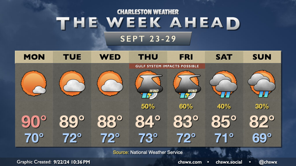
The week ahead: Feeling summer-like with tropical intrigue for late week
Well, it might be fall, but our local weather will continue to betray the calendar for a few more days as Atlantic high pressure to our east and ridging aloft keeps things warmer than normal as we head into the last week of September (already?). Then, things turn a little more interesting as we watch for the potential for a tropical cyclone to move northward through the Gulf of Mexico. Depending on how far east the storm develops and tracks, it’s possible we may see some impacts here at home, but it’s very tough to say exactly what that will look like just yet.
For the first few days, though, much of us will stay rain-free. There’s an outside shot at some showers and maybe even a thunderstorm further inland as some energy moves by to our northwest on Monday, but most of us in the metro should dodge them. After touching 89° on Sunday, we might briefly head back to 90° on Monday for the first time since September 1. Upper 80s heat continues Tuesday and Wednesday with partly cloudy skies, though clouds could be increasing a bit later Wednesday ahead of whatever might be in the Gulf.
Coastal flooding will continue to be an issue with the afternoon high tides through at least Wednesday, though this king tide cycle will be diminishing as we go. Still, minor flooding can close some roads, so keep an ear out for Coastal Flood Advisories from the National Weather Service.
Tropics: Latest on the Gulf system, now tagged Invest 97L
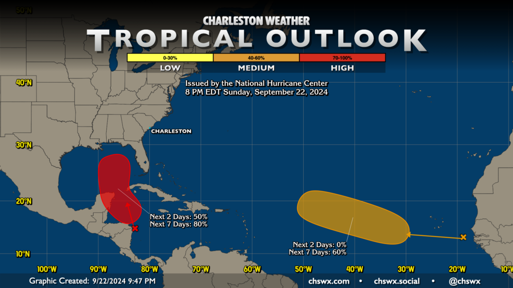
We’ve been watching an area in the Gulf and Caribbean for possible tropical development for the past week or so, and it is becoming increasingly likely that we will see something develop in the next few days. NHC now gives this area 50% odds to develop in the next two days, and 80% odds to develop during the week. This weekend’s model guidance has converged on a solution where something develops and moves northward eventually as a hurricane, but timing, exact intensity, and precise location are still quite a bit in the air, especially since we don’t have a low-level center for the models to lock onto just yet.
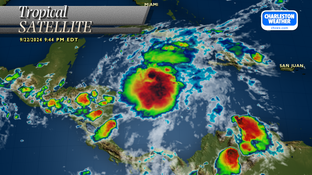
The area of thunderstorms in question, tagged as Invest 97L by the National Hurricane Center on Sunday, has been looking pretty healthy, with possibly the beginnings of a broad circulation based on some (albeit sporadic) station data. The Hurricane Hunters will be flying into 97L on Monday to try to get a better understanding of what’s happening inside the area of disturbed weather. Getting direct samples of the storm from the recon mission will be extremely helpful in calibrating the models, which should help us begin to hone in on some of the finer details as we get closer to the end of the week. If the storm develops as expected, it will get the name Helene.
It’s ultimately tough to tell what our impacts will be. Guidance is fairly unanimous as of this evening that the center passes to our west; how close it passes will ultimately determine the strength of impacts we feel here. Generally speaking, tropical cyclones that come ashore along the Florida Gulf Coast on a northerly track can bring us some rough weather, including heavy rain, gusty winds, coastal flooding, and maybe even a tornado or two — Irma, Debby, and Elsa are storms in the recent past that are good examples of these kinds of impacts.
Right now, the going forecast indicates the risk for showers and thunderstorms beginning Thursday, peaking overnight into Friday, with gusty winds possible. Again, specifics are highly dependent on the track of the system; a further west track limits our impacts here, and vice versa. You’ll want to keep an eye on the forecast as we head into the second half of the week as there will be changes and refinements.
Elsewhere in the tropics, a wave coming off the coast of Africa has a medium chance of developing into a tropical cyclone in the next week as it moves west-northwest across the Atlantic. That one’s pretty far out and not really a concern at this point (if ever).
Weekend: Cooling off some
While the forecast for the weekend is low confidence at this point given the uncertainty with the development and evolution of future Helene, the going thinking right now is that high pressure will wedge southward, keeping some moisture in the area but also taking the edge off the late-season heat as well. Again, this forecast is certainly subject to change as we go on through the week, so stay tuned.
Follow my Charleston Weather updates on Mastodon, Instagram, Facebook, Bluesky, or directly in a feed reader. Do you like what you see here? Please consider supporting my independent, hype-averse weather journalism and become a supporter on Patreon for a broader look at all things #chswx!