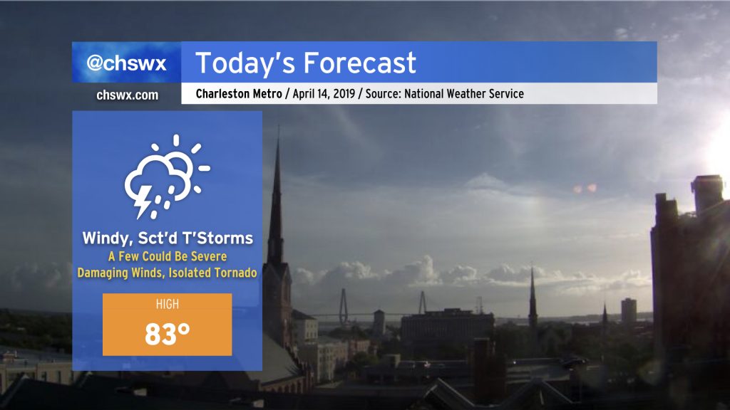
Windy and warm with strong to severe storms possible later today
We have a potentially busy weather day in store today as a strong cold front — which has been responsible for several strong, damaging tornadoes in Texas and Mississippi — cuts its way across the Southeast toward our area tonight.
Warm and muggy start
Temperatures are already in the low to mid-70s across the area as of this writing (8:40am). With some decent sunshine to start the day, instability has begun to develop in spots. Cloud cover should increase as the day goes on, but that won’t likely temper the buildup of energy too much as strong southerly winds transport warm, moist air into the area.
Winds to increase

As temperatures warm into the upper 70s and low 80s, we will begin to tap into stronger winds aloft in the 40-50 knot range. This will mix down to the surface with sustained winds around 20-25 MPH with gusts near 40 MPH. Please be careful if you are driving over bridges as those areas will be most exposed to the higher wind speeds.
This low-level jet is expected to perk up even further as storms approach the area this evening, helping to provide a damaging wind risk in the strongest thunderstorms later today.
Severe weather threat: Late afternoon and evening
The severe weather forecast is very tricky for our neck of the woods. On the one hand, there will be plenty of wind shear — enough that even with waning instability we could see some episodes of damaging wind gusts as the front moves through. On the other hand, we still have chilly shelf waters — upper 60s temperatures in the harbor — and that will lend a stabilizing influence as the seabreeze pushes inland.
The seabreeze is an interesting wildcard in today’s forecast. NWS noted in its discussion that it may be vigorous enough to kick off some showers and thunderstorms earlier in the afternoon. If this happens, the severe risk could be greater with improving upper-level support as well as sufficient instability for damaging wind gusts and even a tornado or two along boundaries. There is support for at least a few showers in the convection-allowing models in the noon-2pm timeframe; it will be interesting to see if this materializes. The morning weather balloon indicated capping — a layer of warm air aloft — around 10,000 feet, but given strong surface heating, I suspect this could be eroded fairly quickly. Convective inhibition values were fairly low (-20 J/kg), and this suggests that it won’t take much of a trigger to kick something off.
Given this relatively uninhibited environment, it is also quite possible that showers may erupt ahead of the line and spoil the severe threat completely. Wouldn’t be the first time. However, there is not much support in the models for this scenario at this time. We’ll cross our fingers.
Bottom line: The main threat for severe weather in the Charleston metro area appears to be from 4PM-9PM with the main concern being damaging wind gusts. Large hail and a brief tornado may be possible, too. It is conceivable a Severe Thunderstorm Watch could be needed later this afternoon. Be sure you can receive warnings — NOAA Weather Radio is a great way to do this, as well as local news smartphone apps.
High Water Festival Day 2

Those of you going to High Water Festival today will want to keep a close eye to the sky, especially later this evening as the potential for strong to severe thunderstorms will be highest with some of the headlining acts. Outside of thunderstorms, winds will be very gusty — up to 40 mph at times — so hold onto your hats!
Be sure to listen closely to venue staff in case severe weather threatens. Outdoor concerts and severe weather often do not mix well.
Stay tuned…
I am out of the weather office for a good bit of today working markets, but I’ll have updates as needed over on social.
Follow my Charleston Weather updates on Mastodon, Bluesky, Instagram, Facebook, or directly in a feed reader. Do you like what you see here? Please consider supporting my independent, hype-averse weather journalism and become a supporter on Patreon for a broader look at all things #chswx!