Spring’s last gasp?

Today we find ourselves between two fronts: one that will be pushing off the coast (but perhaps not before kicking off a shower or storm or two) and another that will provide what may very well be Spring’s last gasp.
Recapping yesterday’s storms
Despite a well-primed atmosphere, Sunday’s storms largely fell short of severe limits as a weak cap allowed popup storms to fire off early, ultimately limiting the available instability ahead of the main batch of thunderstorms as it advanced from Georgia. There was one report of downed trees in West Ashley (pictured in the tweet above), as well as a few reports of small hail in downtown Charleston as the same storm moved through.

Many locations received at least a little beneficial rainfall. Taking a look at CoCoRaHS reports this morning, we find that many locations in the Charleston metro area (roughly along US-17) received around a half-inch of rain, give or take a tenth here or there. My station (SC-CR-151) clocked in at 0.46″ of rain, which was the most since 0.63″ fell on April 20. The jackpot in the Tri-County so far: 2.13″ of rain at station SC-CR-153 two miles north of Edisto Beach. This matches up well with the radar estimates shown above.
Despite 3/4″ of rain at the airport on Sunday (which, absurdly, is the second wettest day of the year, as Dave Williams shows above!), we remain in a significant deficit for the year (-7.48″). I anticipate moderate drought continuing in Thursday’s drought monitor. Unfortunately for lawns and gardens, we revert back to a dry pattern for this week.
From summer to spring and back again

A series of cold fronts that will swing through today will shift us out of the summer-like pattern we’ve been under over the past week. In the wake of these fronts, some rather pleasant air for mid-May will build in for Tuesday and Wednesday with highs topping out around 80° and low humidity as a trough aloft swings through the area.
This gasp of Spring doesn’t last as an upper-level ridge builds back in across the area starting Thursday. By the weekend, we’ll be flirting with 90° each afternoon as a more tropical airmass steadily builds in. It is conceivable that we could deal with a popup storm or two each afternoon starting Friday into Saturday. This will be driven by just how strong the ridge of high pressure aloft can get, though. For its part, the NWS forecast remains silent on precipitation through Sunday. (This could change, though!)
Any more cool air on the horizon?
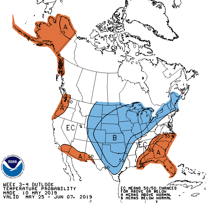
It is conceivable that we may slide firmly into summer-like temperatures after our shot of spring-like air this week. Ensemble runs of the GFS and Euro (where the model is run multiple times with subtle perturbations in the model’s initialization) strongly favor above-normal temperatures. The Climate Prediction Center is all-in on this, with pretty good probabilities of above-normal temperatures as we head into June. So, Spring fans, soak in Tuesday and Wednesday — odds are we won’t get many more days like that until October.
Follow my Charleston Weather updates on Mastodon, Bluesky, Instagram, Facebook, or directly in a feed reader. Do you like what you see here? Please consider supporting my independent, hype-averse weather journalism and become a supporter on Patreon for a broader look at all things #chswx!