Dorian: Watch and wait mode continues
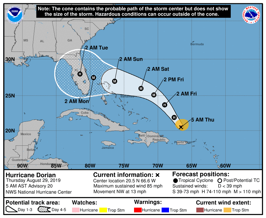
We in #chswx continue to monitor Hurricane Dorian’s progress in the southwest Atlantic. As of 5am, Dorian had maximum sustained winds of 85 MPH and was moving NW at 13 MPH. On the forecast track, it makes landfall somewhere along the east coast of Florida as a major hurricane on Labor Day.
Key forecast questions remain
Now that Dorian has cleared Puerto Rico and the Virgin Islands, we are largely in watch-and-wait mode at this point. The expectation remains — and is fairly well-supported in the guidance members — that a ridge of high pressure to the north of Dorian will steer the storm more to the west starting tomorrow. How strong and how far west that high pressure ridge builds is the key forecast question right now for South Carolina, as this will have direct correlation to where the storm eventually recurves.
Our NWS office, along with Morehead City, Greensboro, and Blacksburg, will begin releasing upper-air soundings (weather balloons) every six hours starting today. This will help sample the high pressure more closely, which should feed better data into the models. We should start to see the benefits of this extra data tomorrow. Until then, expect plenty of “window-wiping” — model solutions with a common theme moving back and forth on the details. (“Window-wiping” is exactly why you should rely on the National Hurricane Center forecasts!)
Bottom line
- Watch and wait mode continues for SC. No imminent, direct threat from Dorian as of now. Continue to monitor National Hurricane Center forecasts.
- Model solutions continue to vary substantially beyond Labor Day. Much to watch.
- Additional data feeding the models should hopefully bring some stability to their solutions starting tomorrow.
Follow my Charleston Weather updates on Mastodon, Bluesky, Instagram, Facebook, or directly in a feed reader. Do you like what you see here? Please consider supporting my independent, hype-averse weather journalism and become a supporter on Patreon for a broader look at all things #chswx!