[UPDATE 3] Significant coastal storm may disrupt holiday travel Monday

Holiday travel will become increasingly difficult as a low pressure system develops in the Gulf of Mexico and heads our way Sunday into Monday, bringing heavy rainfall, gusty winds, and the threat for coastal flooding to the area.
8:30 PM: This post has been updated with the latest forecast information.
Heavy and perhaps record-breaking rainfall expected
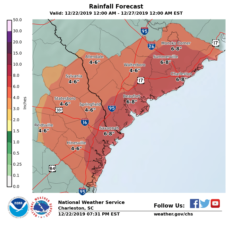
At 3:31 PM, the National Weather Service tweaked the rainfall forecast down some, with 6-8″ generally expected now with locally heavier amounts. This is nothing to slouch at! Several rounds of particularly heavy rain are possible overnight Sunday into Monday, including near what looks to be a very high 5:27am tide. (More on that in a sec.) If this forecast verifies, it is conceivable that the ~5″ rainfall deficit for the year at the airport will be eliminated. (It’ll be a little harder to erase the 9.88″ deficit at downtown Charleston, but this storm will take a good whack at it.)
The exact amount of rainfall will vary based on where these rain bands ultimately set up. Some high-resolution guidance keeps a lot of the heaviest rain offshore, but much of the global models as well as the 3km NAM continue to show a bullseye of up to 6-8″ across the Charleston metro area during the day on Monday.
Periodic showers will continue through Sunday night before turning heavier, with the bulk of the heaviest rain falling overnight Sunday through early Tuesday morning.
Rainfall records in jeopardy
As one might imagine, we may see new daily records for rainfall in the next couple days. The current records are as follows, courtesy of the forecast discussion from the National Weather Service forecast office here in Charleston:
Charleston International Airport
- December 22: 1.85″ set in 1994
- December 23: 4.00″ set in 1941
Downtown Charleston (Waterfront Park)
- December 22: 1.71″ set in 1929
- December 23: 2.93″ set in 1941
Coastal flooding threat with the Monday morning high tide
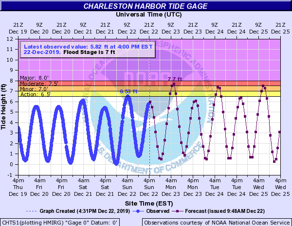
With high astronomical tides and a driving easterly wind, salt water flooding looks to be a done deal for Monday morning, with a current forecast height of 7.7′ in the harbor around the 5:27am high tide. Combine that with the likelihood of rainfall — and the potential for some enhanced rainfall in the Tri-County area around that time — and you have a recipe for significant flooding concerns across parts of downtown Charleston. If things turn out the way they currently look, be ready for the potential for impassable roads in much of downtown during the day Monday.
The risk for coastal flooding will continue with the morning high tide cycles through at least Wednesday, according to the latest forecast.
Flash Flood Watch until Tuesday morning
As one might expect, the National Weather Service has issued a Flash Flood Watch that includes the Charleston Tri-County area until early Tuesday morning.
Flooding concerns will not be limited to downtown Charleston, either. Flooding will be possible in lesser-known, but still vulnerable, places in the metro area including parts of North Charleston, West Ashley (especially near Church Creek, a gauge we will need to watch carefully), and Summerville.
Be ready for the potential for flooded-out roads. Remember, if you encounter a flooded road, make the smart choice: Turn around, don’t drown.
Strong winds may bring trees down
Coincident with all this rain will be the potential for strong winds, particularly and especially near the coast overnight Sunday into Monday morning as the low makes its closest approach. Winds out of the east at 20-30 MPH will be common, with gusts over 40 MPH. Given that root systems may be weakened significantly by the expected torrential rainfall, a few trees may fall, causing power outages and other damage. Keep a flashlight handy just in case.
You’ll want to take time this morning to secure loose outdoor items, including and especially Christmas decorations!
A Wind Advisory goes into effect at 10PM and will be in effect through 10AM Monday.
It’ll be better for Christmas

We’ll begin to dry out and warm up on Christmas Eve, with a few straggler showers possible before sunset, especially near the coast.
Christmas Day looks pleasant, with partly cloudy skies and highs in the upper 60s as the pattern turns warmer for the last few days of 2019.
Bottom line
Keep a close eye on forecast updates Sunday and Monday. Be ready to adjust travel plans as travel will be hazardous, especially in flood-prone areas. It’ll get better starting Tuesday, and Christmas Day will bring quiet weather.
Follow my Charleston Weather updates on Mastodon, Bluesky, Instagram, Facebook, or directly in a feed reader. Do you like what you see here? Please consider supporting my independent, hype-averse weather journalism and become a supporter on Patreon for a broader look at all things #chswx!