A devastating day comes to a quiet end

April 13, 2020 will join April 16, 2011 and March 15, 2008 as days that will live on in local weather infamy. Some people lost their lives today — at least five fatalities were reported in Hampton County from the supercell depicted above. Others in places like Walterboro, Summerville, and Moncks Corner suffered serious damage to their homes or lost them entirely. It was a thankfully rare day that we hope to not see again for a good long while.
Today in photos
The storms caused widespread damage across the area, with numerous downed trees and power lines in addition to damage to buildings. Here are just a few photos I received during the course of this morning…
There were also instances of flooding as the initial squall line stalled out as it neared the coast. There were reports of flooding in downtown Charleston as well as communities in North Charleston, and the airport set a new daily rainfall record of 2.83″. (My gauge in West Ashley measured 2.40″.)
Rare, long-track supercells produced the most damaging weather
Storms today were well-organized and traveled long distances. The supercell thunderstorm that devastated small towns in Hampton County, flipped airplanes in Walterboro, and damaged homes in Moncks Corner originated in southeast Georgia near Sylvania. The radar began to pick up on tight rotation as the storm reached Hampton County, and from there, low-level rotation was detected for more than 85 miles before the storm moved into an area where radars had a tougher time sampling the lower levels. The storm spawned tornadoes all the way into Georgetown, and even rode the coast for a time bringing tornado warnings all the way to the Grand Strand.
A second storm developed strong rotation over Edisto Beach, briefly flashing a tornado debris signature. This tornado straddled the coast up through Kiawah Island before broadening and moving away, damaging property on Edisto, Seabrook, and Kiawah in the process. The radar had a bead on low-level rotation for up to 28 miles.
Finally, this guy was on radar for a time:
This supercell originated in southeast Georgia and then went offshore. While offshore, it developed a strong bounded weak echo region (BWER), which gave the storm an eye-like appearance at the center of the mesocyclone. (I’m still trying to figure out what to name it.)
National Weather Service survey teams are and will continue to examine the damage to determine whether straight-line winds or tornadoes caused them, and if they were tornadoes, how strong they were. As those surveys come in, I’ll relay the findings.
Tuesday’s forecast: Increasing clouds, maybe a stray shower
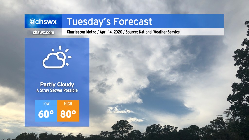
The cold front which instigated all of this mess will stall out to our south later tonight. While we should stay mostly dry on Tuesday, clouds will increase as low pressure develops and buckles the front northward a little bit. There’s a chance for a stray shower or two starting late in the day Tuesday through early Wednesday morning, though the odds favor mostly dry weather for a vast majority of the Tri-County. Highs will top out around 80, and while there will be a touch of humidity, it shouldn’t feel too bad outside.
Finally, I want to thank everyone who followed along with me and my Carolina Weather Group compadres as we covered severe weather this morning on social and streaming. It means the world that you trust us with your weather information, and we work hard to keep that trust every day. I want to send a special shoutout to my patrons, whose generous donations keep things humming along well here. I’ve been able to beef up quite a few of my data sources thanks to your generosity, and it all came in handy this morning as I fought to stay on air through power blips and reboots.
Let’s hope we don’t have to do this again for a long, long time.
Follow my Charleston Weather updates on Mastodon, Bluesky, Instagram, Facebook, or directly in a feed reader. Do you like what you see here? Please consider supporting my independent, hype-averse weather journalism and become a supporter on Patreon for a broader look at all things #chswx!