Monitoring conditions to the west for Monday’s severe weather threat
Good Sunday morning to you all. Once again, the Charleston metro area finds itself watching the weather intently for the potential for a few strong to severe thunderstorms, particularly tonight into tomorrow morning. The area is outlined with an enhanced severe weather risk, which is a 3 out of 5 on the Storm Prediction Center’s scale. Unfortunately, damaging winds and potentially strong tornadoes are once again on the table.
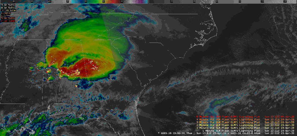
Situation as of Sunday morning
This morning started out fairly sunny across the Lowcountry. Temperatures have warmed quickly to the mid-70s as of 10am, and some maritime air has advected onshore with southeasterly winds, bringing dew points into the low 60s.
We continue to watch a large cluster of showers and thunderstorms driven by a shortwave trough as it moves west to east across AL and GA this morning. Cloud cover will be on the increase as the day goes on, and we should expect rain to begin in the Tri-County area after noon. These storms should remain sub-severe for the most part, though it is worth noting that this morning’s heating and maritime air have allowed some surface-based instability to creep onshore in the Tri-County according to the Storm Prediction Center’s objective analysis.

It appears this axis of instability will shift northward along the coast with time, but we’ll want to see if any of it can stick around as it could portend a damaging wind threat near the coast during the afternoon hours, ahead of the expected main round (or two) of severe storms later tonight.
Warm front watch

A key component of today’s severe weather threat is a warm front that is expected to sharpen and move northward as the day goes on. Right now, according to the Weather Prediction Center’s surface analysis, it is draped across far southern GA and AL. It is south of this boundary that the greatest combination of wind shear and instability — and the greatest risk for damaging winds and tornadoes — will be found.
The cluster of thunderstorms that will affect the area in the afternoon should help to keep the warm front at bay for much of the day, as rain falling to the north of the front will help to reinforce the cooler airmass. However, models have been tricky as to exactly where this dividing line wins out. If thunderstorms do become severe this afternoon, damaging winds and tornadoes will be possible.
Severe weather timeline for tonight and tomorrow
This evening: There are still some questions around the severe weather threat for this evening. If the warm front lifts northward across the Tri-County earlier in the evening, the risk for supercell thunderstorms producing potentially all hazards (damaging winds, hail, tornadoes) will increase ahead of the expected squall line tomorrow morning. Recent guidance suggests that this is going to be a very close call for the Charleston metro, with the warm front perhaps staying just to our south until early Monday morning. Regardless, be on guard for severe weather potential this evening into overnight.
Early Monday morning through noon: A squall line is expected to take shape to our west, with damaging wind gusts and embedded tornadoes the primary concern. This squall line will have plenty of low-level jet support, and a surface low lifts to our north, so goes the warm front, placing the metro area within the warm sector. Wind shear will be sufficient for damaging straight-line winds and tornadoes, with the potential for a couple of those tornadoes to be strong. The squall line should clear the coast by midday, with improving weather thereafter.
Bottom line
- Be prepared for the potential for strong to severe thunderstorms as early as this afternoon, but most likely into the overnight hours into Monday morning. Be pulling in loose items this morning; your neighbors will thank you from a safe, non-virus-transmitting distance.
- Severe thunderstorms are most dangerous at night! Make sure you have multiple, reliable warning sources and that they can wake you. Keep phones on the charger and off Do Not Disturb. When a warning is issued, take action immediately — the strong low-level jet infers very fast storm motions. NWS forecasters will do their very best to give you as much lead time as possible, but the science is such that it may not always be the case every time.
- If you are living in a mobile home, find a site-built shelter to stay in tonight. Strong winds and tornadoes devastated mobile home communities in Hampton County this past weekend. Shelter first, then isolate yourselves to mitigate the spread of COVID-19.
- Be patient. Today could very easily be a regular stormy day with little to no severe weather. This does not mean that the threat is necessarily lessened or a bust entirely; indeed, the consensus is that the atmosphere will recharge overnight for the main severe weather event.
You can read my updates from today’s evolution on the live blog (now closed for the night).