#chswx notes: Unusual chill, April 13’s final tornado tally

A relatively mild winter has one last trick up its sleeve as an unusually chilly airmass has descended from the Arctic onto the eastern half of the country. This brought Central Park in New York City only its second May 9 snow on record (first was in 1977) and has helped send numerous low temperatures to record levels all the way into Alabama and Mississippi.

The Lowcountry has not been exempted from this chilly snap. While frost and freeze conditions haven’t been a problem here, we have had a few days of rather cool early May weather. On Thursday, the high topped out at 71° — good for seventh-coolest on record for the date at the airport, and the third-coolest day when factoring in the fact that there was no precipitation recorded. (Records go back to 1937).
Today may run even cooler, with the National Weather Service forecasting 69°. If this verifies, it would only be the second time on record at the airport that high temperatures on May 9 were below 70°. The coolest May 9 on record occurred in 1980, when the high topped out at 68° with a trace of precipitation. We’ll see a gradual scouring of clouds today, so to achieve such cool temperatures with May sun angles is quite a feat.
NWS Charleston confirms 16th and final tornado from April 13 outbreak
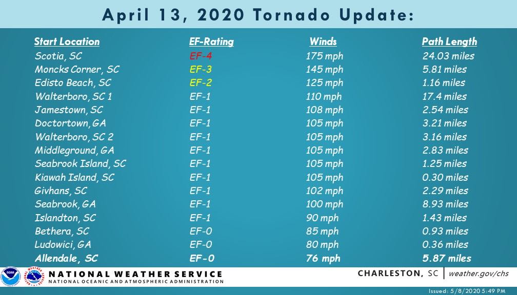
The National Weather Service in Charleston has finished its survey of the April 13 tornado outbreak, having confirmed sixteen tornadoes (including the first EF-4 in its area of responsibility). A final EF-0 was cataloged in Allendale, SC yesterday.
The strongest tornado from the event in the Tri-County area was the EF-3 in Moncks Corner, which caused quite a bit of damage in the Cedar Island neighborhood. That tornado went on to produce EF-1 damage in Jamestown, and was part of the same supercell that spawned the EF-4 in Hampton County and additional tornadoes in Walterboro and Givhans.
In Charleston County, an EF-2 tornado struck Edisto Beach with a supercell that developed offshore; this supercell produced additional EF-1 tornadoes on Seabrook and Kiawah Islands.
For a full recap of all preliminary storm reports from the April 13 event along with an interactive map of tornadoes and damage paths, be sure to see the National Weather Service’s event page.
Hurricane season starts June 1
This past week was Hurricane Preparedness Week, a reminder that we are getting close to the start of the Atlantic hurricane season. In true 2020 form, the state of the atmosphere and water temperatures in the Atlantic and Pacific oceans suggest a potentially active year on the horizon according to the researchers at Colorado State University.

Now’s the time to take stock of your hurricane preparedness. Make sure you have an evacuation plan and that your family knows what to do and where you’re headed if in fact it comes to that. (It’s come to that every year since 2016, so we have had good practice, unfortunately.) Stock up on your supplies — something we are all pretty used to in the time of COVID-19 — and make sure your insurance documents are in good order. Now is the best time to get ready — not when a storm is bearing down. With any luck, we won’t have to pile an evacuation on top of the pandemic, but we should be ready in case we do.
Follow my Charleston Weather updates on Mastodon, Bluesky, Instagram, Facebook, or directly in a feed reader. Do you like what you see here? Please consider supporting my independent, hype-averse weather journalism and become a supporter on Patreon for a broader look at all things #chswx!