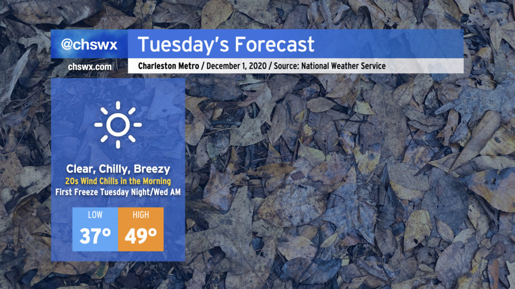
We in the weather community have been talking about this cold snap for a while, and it is finally here. Tuesday promises to be a very chilly day — the coolest since mid-February — with highs struggling to reach 50° despite full sunshine. A persistent westerly wind will keep temperatures feeling even colder, too, with wind chills in the upper 20s expected in the morning. Make sure your loved ones, two and four-legged, have a warm place to be tonight (and for the next couple nights).
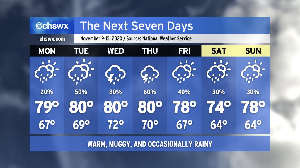
Fall’s hiatus continues this week as we sit between high pressure to the north and Tropical Storm Eta to the south. Monday looks to be the driest day of the week with just a slight chance of showers throughout the day. Rain chances head up into Wednesday as tropical moisture associated with Eta gets drawn up into the area by a frontal system approaching from the west. This front looks to stall out by the end of the week, keeping a chance for showers in the forecast through the weekend. (Eta could make the weekend a little more wet and windy, so consider that forecast somewhat low-confidence at the moment.)
Temperatures will remain rather warm for early to mid-November. NWS notes that some record high minimum temperatures could fall this week, with lows in the 70s forecasted especially Wednesday and Thursday. (For contrast, the typical high temperature this time of year is around 71-72°.) Highs will generally run in the upper 70s to low 80s, roughly 8-10° above normal for this time of year.
If you’re looking for a shift back into Fall, this week ain’t it. While we may cool off as we get into the following week, long-range guidance continues to hit on above-normal temperatures remaining the norm (as one would expect in a La Niña winter, which tends to trend warmer and drier in the Southeast).
It’s June 1, and that means that the Atlantic hurricane season has once again officially started. (Don’t tell Arthur and Bertha that they were early to the party.)
Through November 30, we’ll be keeping a weary eye on the Gulf of Mexico, Caribbean Sea, and Atlantic Ocean for possible tropical mischief. It could be a busy year for tracking storms, too. Let’s dig in.
850mb temperatures and 500mb heights from a RAP13 model projection in May, I swear.
A relatively mild winter has one last trick up its sleeve as an unusually chilly airmass has descended from the Arctic onto the eastern half of the country. This brought Central Park in New York City only its second May 9 snow on record (first was in 1977) and has helped send numerous low temperatures to record levels all the way into Alabama and Mississippi.
After a rather pleasant weekend, temperatures will begin to trend back above normal this week with chances of showers and perhaps a few thunderstorms each afternoon. Highs will be getting into the mid-80s by midweek, marking a return to that summer preview we were feeling toward the end of March. A cold front will move through the area sometime later this week, bringing a reduction in temperatures, but showers may yet stick around. It’s a fairly low confidence forecast looking toward next weekend with a fair bit of divergence in the models, so stay tuned for updates as things will undoubtedly need to be ironed out.