Strong to severe storms may become widespread ahead of a cold front Thursday
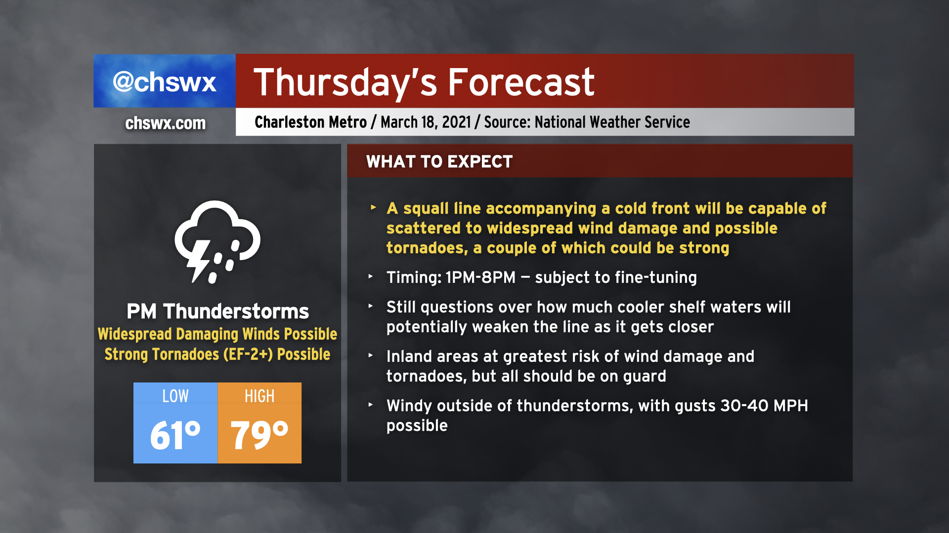
Severe weather appears to be in the cards for Thursday as a cold front approaches the area in the afternoon and early evening hours. This cold front is expected to be bringing a squall line with it, and the atmosphere ahead of the line will become increasingly favorable for sustaining severe weather. Temperatures will surge to near 80° especially away from the immediate coast before being tamped down later in the day. Even outside of thunderstorms, it will be windy, with gusts 30-40 MPH possible thanks to a strengthening low-level jet, which will help contribute to increased shear to help organize severe thunderstorms.
The squall line is the main concern, though. The line could enter western portions of the Tri-County as early as 1-2 PM, and may exit as late as 8 PM, based on the National Weather Service’s latest timing estimates. The line is slowly starting to take shape across Louisiana, and we will want to watch its progress closely over the next 24 hours to ensure timing and forecast is on track. A somewhat later arrival could mean more time for the atmosphere to destabilize, increasing the severe weather threat.
Hazards with the line include the risk for widespread damaging straight-line winds as well as a few tornadoes — a couple of which could be on the strong side, particularly near the I-95 corridor. Quarter-size hail is a possibility as well. Additionally, while not explicitly modeled in our area, we’ll want to keep an eye on any storms that might try to get going ahead of the line as those could pose a higher tornado risk.
Finally, it’s most important to note that not all of you will see severe weather tomorrow. There are limiting factors at play, including the role that the cooler Atlantic shelf waters may play in stabilizing the atmosphere closer to the coast and just how unstable the atmosphere can ultimately get here due to cloud cover. Severe weather forecasts are rarely a slam dunk in the Lowcountry because of our unique geography. With all that said, though, let’s be ready for the worst, but hopeful for a relatively quiet day.
What is a “moderate risk”?
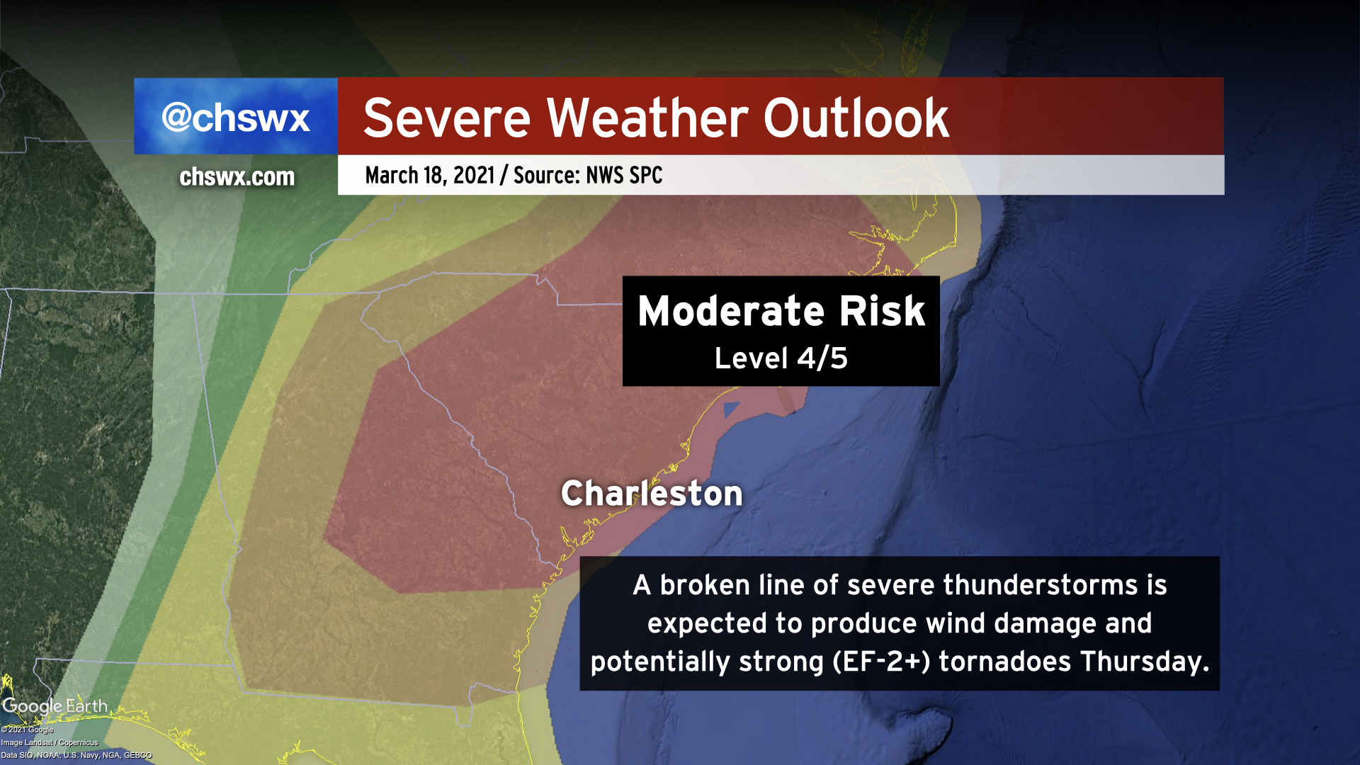
Weather Twitter has been abuzz about the “moderate risk” for severe weather across much of South Carolina in the Storm Prediction Center’s convective outlook . These are rare in this part of the world — the last one was in 2019. (Yes, April 13th was only an “Enhanced Risk.”) The Moderate Risk designation indicates confidence in scattered to widespread severe thunderstorms. For our area, the outlook calls for a 45% chance of wind damage within 25 miles of a point and a 15% chance of a tornado within 25 miles of a point. These are pretty substantial probabilities for this area, and is certainly worthy of our attention.
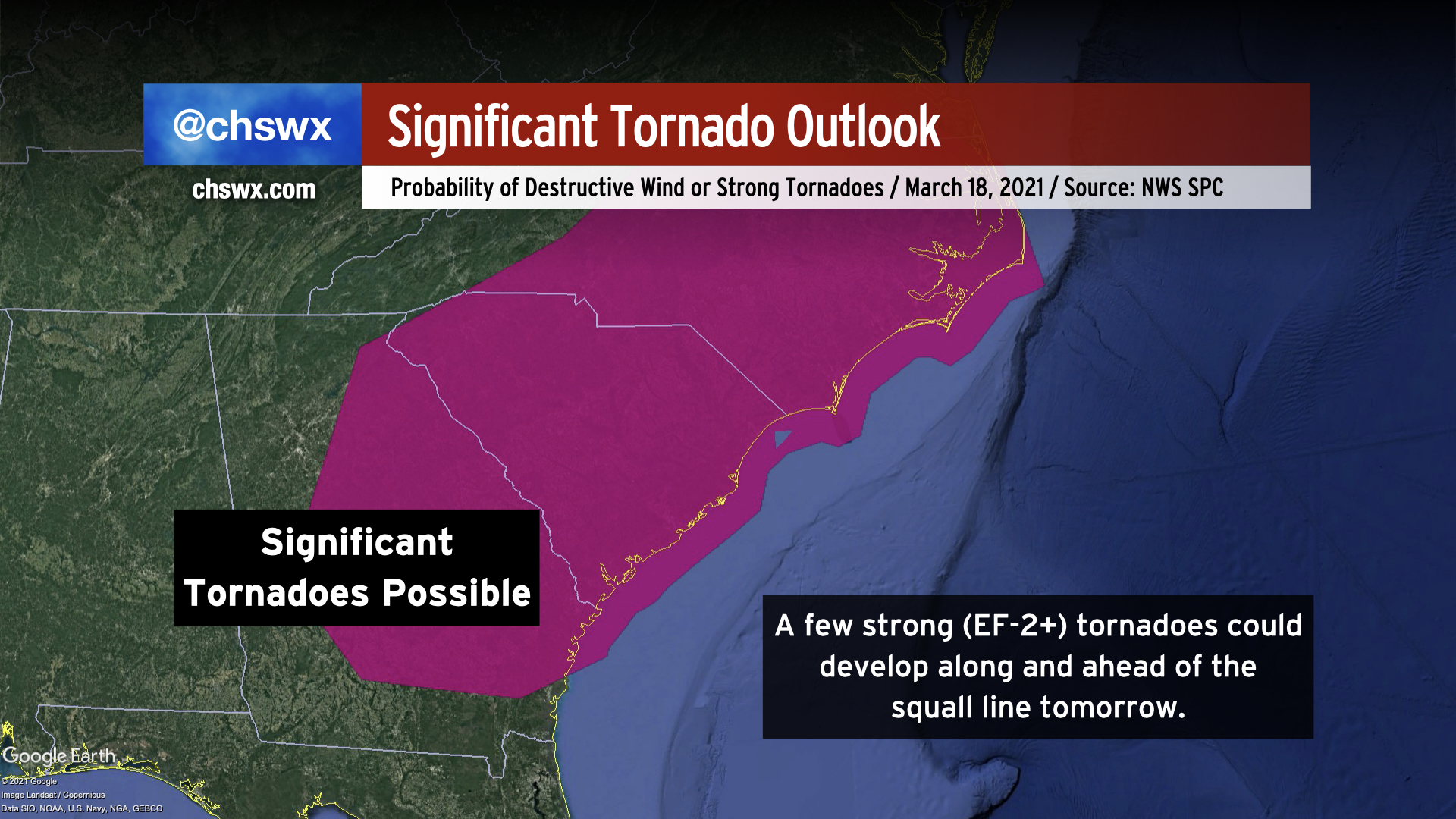
Additionally, the atmosphere will be capable of producing strong, long-tracked tornadoes, with a 10% chance of a strong (EF-2 or greater) tornado within 25 miles of a point. This risk extends from Georgia through the Carolinas into southern Virginia, further calling attention to the volatile environment expected tomorrow.
What I will say, though, is that thunderstorms really don’t care about these risk categories. In fact, these risk categories originally weren’t even designed for public consumption — they are first and foremost guidance to local National Weather Service offices when they consider the forecast for their areas of responsibility.
Regardless of whether the risk heads up or down with subsequent updates, you should be ready for severe weather tomorrow as the atmosphere will certainly be capable of damaging thunderstorms.
What to do tonight
There are a few things you can get together tonight:
- Bring in loose items from outside. Loose items turn into projectiles when severe weather hits. Tornadoes can take these items and stick them in places you didn’t think were possible. Be a good neighbor and don’t add to the danger.
- Review your severe weather safety plan. The safest place to be in a tornado warning is in an interior room or closet, with as many walls between you and the outside as possible. Seeking shelter in site-built structures are a must — mobile homes just don’t do well in severe weather. Bring some things to your tornado safe room, too, such as helmets, shoes, pet carriers, and any other important items you may need.
- Make sure you have redundant, reliable ways to receive weather warnings. NOAA Weather Radio and smartphone apps such as any of the weather apps from the local news stations will do the job (the only difference with those apps is which station’s weather team you like best). Don’t rely on social media for timely warning information, as the algorithms on those services can show you hours-old information. Use social media as a situational awareness enhancement, but don’t use it as a sole source.
What to do tomorrow
- Monitor forecast updates. With the line on the move, we’ll be able to better tell what character of storms we’ll be dealing with and when they will get here. Forecasts will be fine-tuned up to the event, so stay tuned to your favorite trusted weather source for details.
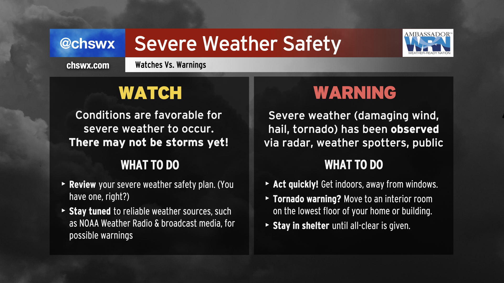
- Listen for watches and warnings. A tornado watch will almost certainly be issued at some point tomorrow. Remember, a watch means that conditions are favorable for severe weather to develop, but it may not be occurring just yet. It’s your signal to heighten your weather awareness. A warning means that severe weather has been observed either by radar or by weather spotters, and that it is imminent for your location.
- Be ready to act quickly. Storms should be moving quickly tomorrow, reducing lead time in some cases. Make sure that if you are placed under a warning — especially a tornado warning — that you seek shelter in your safe place quickly.
- Be prepared, not scared. Easier said than done, perhaps, but if you’ve got your safe place in order, your family is ready to roll, and you have your weather alerting tools, you’re going to be in great position to get through tomorrow just fine. Remember, not everyone will see severe weather.
Cooler and drier for Friday
Once the front is offshore late Thursday/early Friday, the severe weather threat will end and high pressure will build back into the area. We should see some sunshine during the day Friday before clouds increase as a coastal trough sharpens. Temperatures will run in the upper 60s on Friday, much cooler than where we expect to be tomorrow. Right now, the weekend is looking chilly by recent standards, with mostly cloudy skies and the risk for a passing shower each day. (More on this tomorrow.)
Follow my Charleston Weather updates on Mastodon, Bluesky, Instagram, Facebook, or directly in a feed reader. Do you like what you see here? Please consider supporting my independent, hype-averse weather journalism and become a supporter on Patreon for a broader look at all things #chswx!