What to expect overnight from Elsa
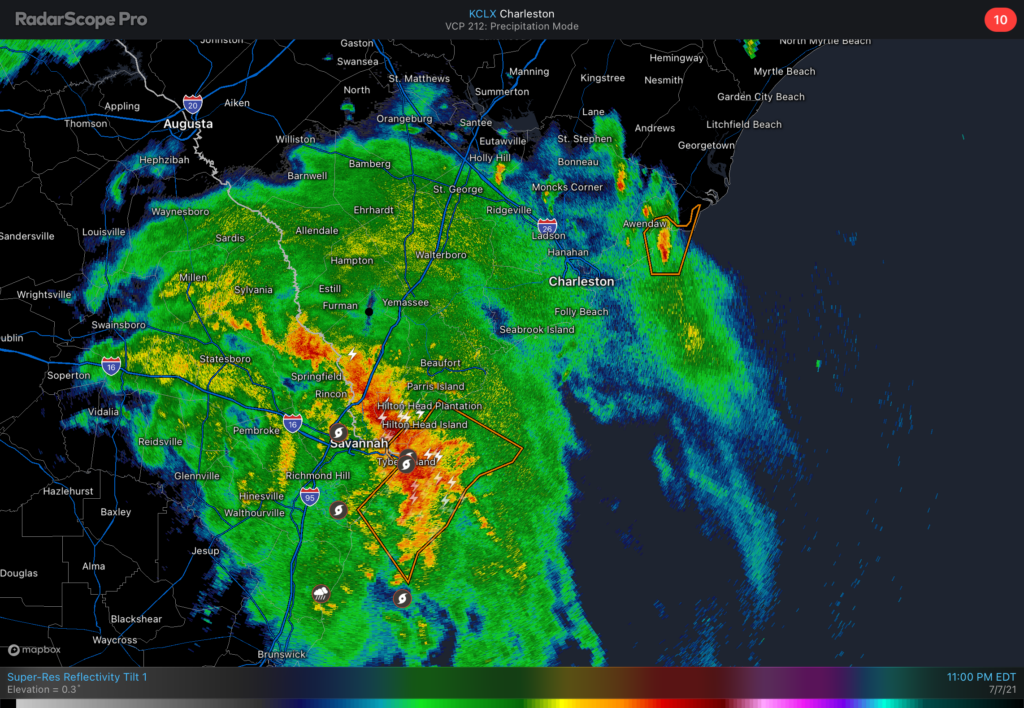
We continue to monitor Tropical Storm Elsa as it moves through southeast Georgia overnight tonight. A Tornado Watch is in effect until 5am across the Lowcountry. The primary concern for tornadoes will be a strong feeder band that is moving north of Savannah into far southern SC as of this writing. It looks like this band will move into the Charleston metro area in the 1-3am timeframe. This band will produce the heaviest rainfall — observers have measured 3”/hr rain rates from this band in Georgia — and provide the best opportunity for an isolated tornado over the next few hours. Discrete cells ahead of this band could also briefly produce tornadoes.
Rainfall
Rainfall continues to be the main concern from Elsa as its primary feeder band marches northward. Given the observed rain rates, there will be a risk for urban flooding in downtown Charleston overnight despite the fact that the band will likely coincide with low tide. We’ll also want to watch the band’s orientation carefully; a north-to-south orientation across the peninsula could mean significantly more residence time for heavy rain. This will need to be watched very carefully.

Case in point: This evening’s high-resolution ensembles suggest the potential for very significant rainfall near and east of Elsa’s center, with a bullseye for 50% probabilities for 3” of rain in 3 hours northeast of Elsa’s center track. This probability extends to the coast as well. Will certainly be a trend to watch as we go into the evening.
Coastal wind threat increasing
Wind gust of 81 mph was observed at Calibogue Sound at 1113 PM. Strong winds up to 80 mph will be possible along the coast northeast into Hilton Head and possibly further northeast up the coast. #chswx
— NWS Charleston, SC (@NWSCharlestonSC) July 8, 2021
The threat for damaging wind gusts in coastal communities is increasing with this band as it lifts northward. Wind gusts exceeding hurricane force have been recorded at Tybee Island and near Forest Beach, SC. As of this writing, NWS has issued a Severe Thunderstorm Warning for the Beaufort and Colleton county coastal areas, citing a risk for 80 MPH winds. We will need to watch these trends extremely closely for the next couple hours as the wind threat may be increasing across the area.
What to do
- Be ready for power outages. Keep your phone on the charger and a flashlight handy in case you lose electricity.
- Ensure you can receive weather warnings that can wake you up. Tornadoes at night are extremely dangerous, and tropical tornadoes can often come with very little lead time. Leave your phone off silent so that Wireless Emergency Alerts can wake you if a Tornado Warning is issued.
What’s next
This band is the main event — once it departs, conditions will gradually improve as an increasingly lopsided Elsa begins to accelerate northeastward through the Carolinas and out to New England by Friday morning. The latest convection-allowing models generally begin to clear the area of Elsa’s main rain band in the 6-8am timeframe, and it will probably be out of here a little bit before that as models can sometimes play things a little slowly.
We’ll see temperatures run back into the upper 80s tomorrow. The calm weather on the back side of Elsa will be short-lived, as scattered showers and thunderstorms should once again fire in the afternoon before dissipating with the loss of daytime heating.
Breaking weather will be over on Twitter this evening — please follow along and stay safe tonight!