Strongest effects from Nicole to arrive tomorrow into Friday: what to expect
Nicole’s roughest weather arrives tomorrow and will last through Friday afternoon before improvement sets in just in time for the weekend. Heavy rain, gusty winds, tidal flooding, and a few tornadoes are all on the table with this event. Here’s what to expect.
4PM advisory: Bordering on a hurricane; Tropical Storm Warnings in effect
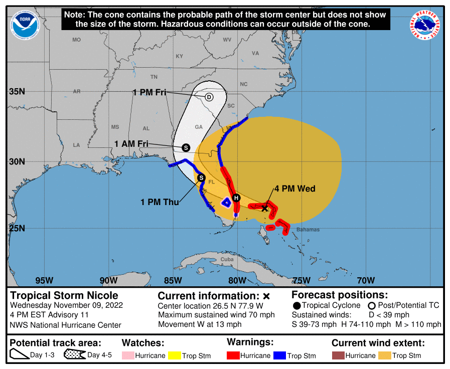
At 4PM, Nicole was bordering on hurricane strength as it moves on from its first landfall at Great Abaco Island in the Bahamas toward a landfall perhaps around Port St. Lucie, FL overnight. Radar images from the Bahamas certainly suggest Nicole has the look of a hurricane with an eyewall trying to wrap around the center.
Tropical Storm Warnings are in effect for Berkeley and Charleston counties, while a Storm Surge Watch continues for Charleston County. I expect at this point that unless Nicole comes in a bit stronger we will not see any tropical headlines raised for Dorchester County; it should be wound down to a depression by the time it makes its closest pass, and it increasingly looks like the center will stay well away from Charleston. Even still, Nicole’s effects will be felt for hundreds of miles from the center, and that includes us. Winds have been gusting pretty frequently into the 30 MPH range at several stations today, and expect that to continue for the next couple days.
Nicole discussion for the Carolinas on Carolina Weather Group
Update at 10 PM: We just wrapped a Carolina Weather Group special episode discussing all things Nicole — check it out in the video above.
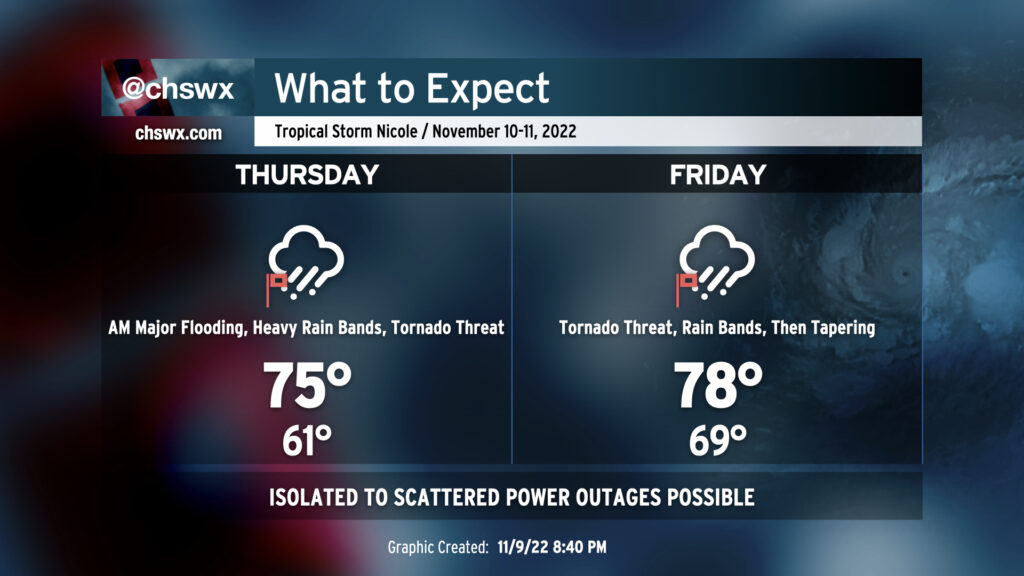
Thursday into Thursday night: Major coastal flooding, heavy rain begins, tornado threat
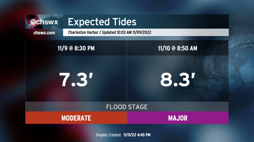
Thursday looks to represent the peak of the coastal flood threat across the area. An 8.3′ high tide is predicted around 8:50am, with flooding likely occurring once again about 2-3 hours either side of said tide. Numerous road closures will occur, with issues creeping up in some of the less-frequently-affected spots such as James Island along Harbor View Road and perhaps even in parts of West Ashley near the Stono. Expect numerous issues right smack dab in the middle of the morning commute — be patient, or just work from home if you have to head downtown.
Rain threat
Making matters dicier, rain is expected to begin Thursday morning as warm, moist maritime air pushes inland, eroding the cool and dry wedge of high pressure. This rain could be heavy at times, exacerbating any salt water flooding and perhaps contributing to a longer-duration flooding event in downtown Charleston. This potential will have to be watched very, very closely. Heavy rain bands should continue well into Thursday night, with the heaviest rain looking to fall mid-morning and beyond. If there’s a sliver of good news, it’s that the dry period we’ve experienced since Ian has primed us well to be a little more resilient to a wider rainfall flooding threat. Still, it’ll bear close watch.
Tornado threat
As we get into Thursday afternoon, we will also have to watch carefully for an increasing tornado threat as Nicole begins to move north and northeast, staying to our west and placing us on the “dirty” side of the storm. Winds at the surface will veer to the southeast throughout the afternoon and evening, advecting in sufficiently unstable air and setting up a favorable vertical shear profile for rotating storms within rain bands. Based on the current expected forward speed of the storm, the tornado threat looks to continue overnight Thursday into Friday, and so you’ll want to make sure that you have redundant, reliable ways to hear severe weather warnings that can wake you. Make sure one of the ways you get warnings isn’t tied to your smartphone. A NOAA Weather Radio is great for this — the Awendaw transmitter is fixed and sounds stronger than ever, BTW — and should be in everyone’s safety kit.
If you should receive a tornado warning on your phone or on the weather radio, move quickly into an interior room on the lowest floor of a sturdy building. Put as many walls between you and the outside as possible. Tropical tornadoes are notoriously fast-moving and hard to warn for, so be ready to move quickly to shelter. The good news is that fast-moving also means the risk is short-lived, so you won’t have to stay in a safe place too long.
Wind threat
Gusty winds will come along with the rain bands as well. Overall, the wind threat from Nicole is lower than what we saw from Ian especially for folks away from the immediate coast. Spots that get heavy rain, though, could still be susceptible to some tree damage even from gusts as low as 40 MPH. Closer to the coast, gusts approaching 40-50 MPH will be more common. Be ready for sporadic power outages due to gusty winds bringing down power lines.
Friday: Rain, tornado threat continues with improvement late
Heavy rain will continue into Friday, and the tornado threat should persist for a few more hours before tapering off as Nicole’s center moves more north of the area.
Rain and flooding threat
Heavy rain bands will continue to be capable of putting down an inch or two more of rain across the area before it’s all said and done. We’ll have to watch this carefully once again as we head toward the morning high tide, which will peak around minor flood stage (7.0-7.2′ MLLW) between 9-10am, as this could lead to another round of widespread road closures even without excessively high tides. Rainfall will begin to taper off as Nicole accelerates northeastward, and we should be rain free by midnight.
Tornado threat
The tornado threat will largely be governed by how fast the storm is moving by the time it gets nearby. Generally speaking, rotating thunderstorms will be possible through at least early afternoon; if the storm is moving slower and instability has a chance to increase, we could see a few more severe thunderstorms fire through late afternoon. Overall, though, Nicole is expected to be moving quickly at this point, and we should be free and clear of the tornado threat — if not the rain entirely — by evening.
Wind threat
Gusty winds will still be an issue especially near the coast as Nicole moves on by. We should see stronger gusts within rain bands, too. Overall, though, the wind threat will be decreasing as Nicole continues to weaken and undergo extratropical transition. Gusts 25-35 MPH will be tapering off heading toward the evening.
Weekend: Sunshine, then turning cold
The sun comes out on Saturday, and we’ll have a really nice day with highs in the low 70s. Cooler air then rushes in behind a cold front, knocking temperatures well below normal for a few days starting Sunday. Sweater weather will be in full force across the area with temperatures more becoming of winter than anything, because for some reason we just can’t play this fall down the middle. So it goes in transitional seasons.
Stay tuned for updates throughout tonight into the next couple days. The good news is that this isn’t anything we can’t handle. You’ve got this.
Follow my Charleston Weather updates on Mastodon, Bluesky, Instagram, Facebook, or directly in a feed reader. Do you like what you see here? Please consider supporting my independent, hype-averse weather journalism and become a supporter on Patreon for a broader look at all things #chswx!