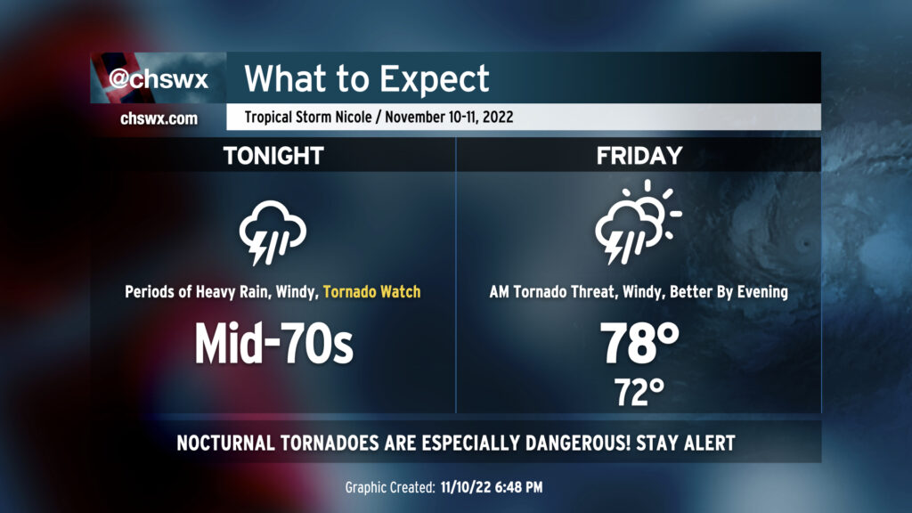
We have a potentially very busy 18-24 hours of weather ahead as Tropical Storm Nicole makes the turn to the north and the northeast overnight into Friday, keeping us on the “dirty” side of the storm. The main concern is overwhelmingly the threat for tornadoes overnight. A Tornado Watch is in effect until 1am, and it wouldn’t be surprising to see it extend even beyond that. Secondary to this will be the continued risk for heavy and potentially flooding rain at times, with gusty winds also a concern.
Nicole’s roughest weather arrives tomorrow and will last through Friday afternoon before improvement sets in just in time for the weekend. Heavy rain, gusty winds, tidal flooding, and a few tornadoes are all on the table with this event. Here’s what to expect.
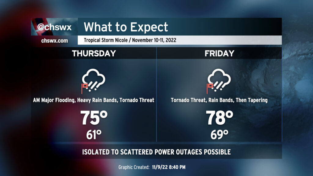
We are breezy but rain-free this evening as dry high pressure remains in control of our weather. It will hang on for a bit for the first part of Thursday, but a gradual deterioration in weather will begin in the afternoon. It’s a good time to finish gathering supplies for a rough period of weather beginning later Thursday through Saturday morning.
Storms have remained mostly at bay today (aside from a few popups in the Walterboro/Summerville corridor) as we put in another hot day with highs topping out at 95° at the airport and 92° at Downtown.
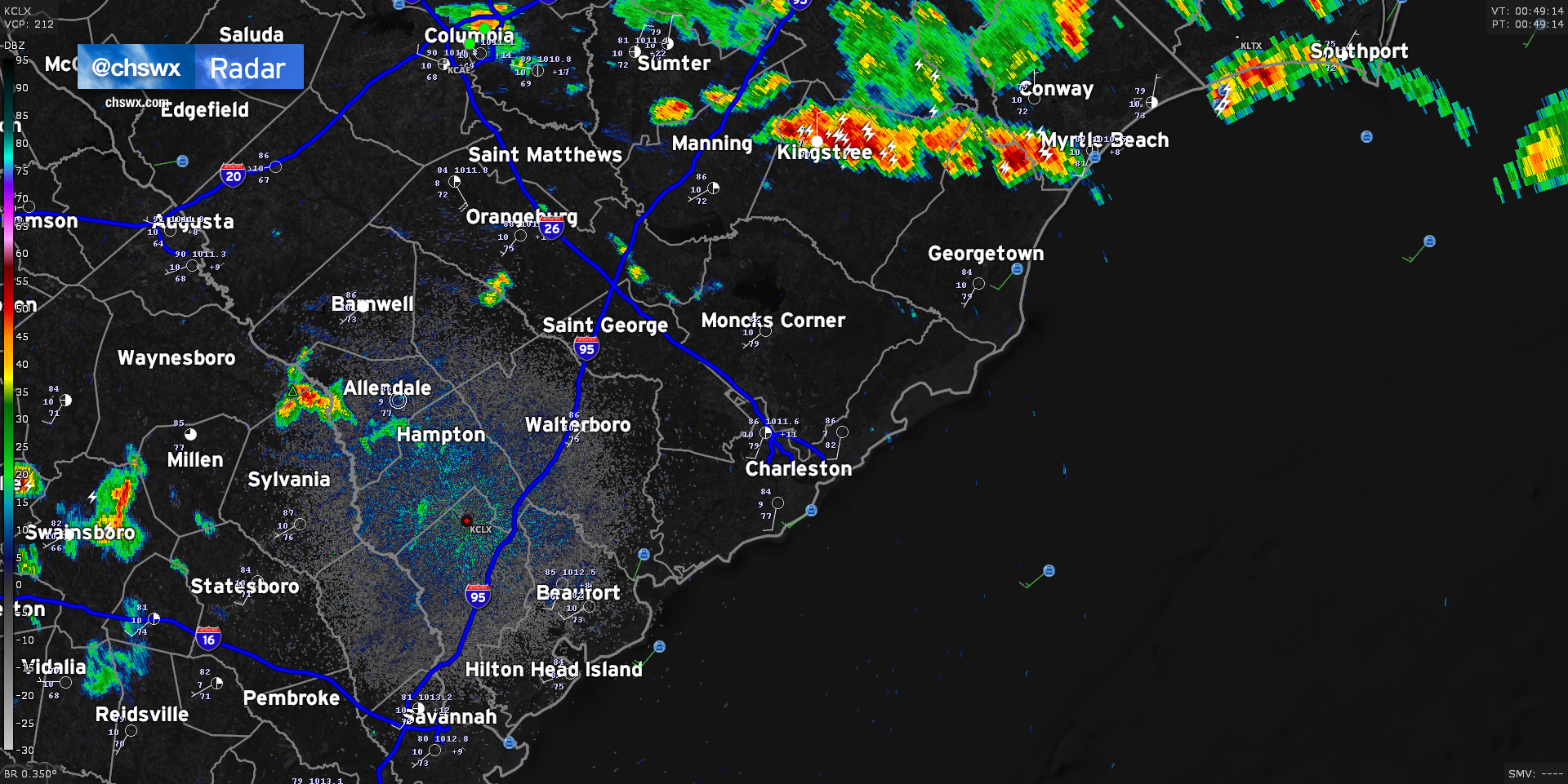
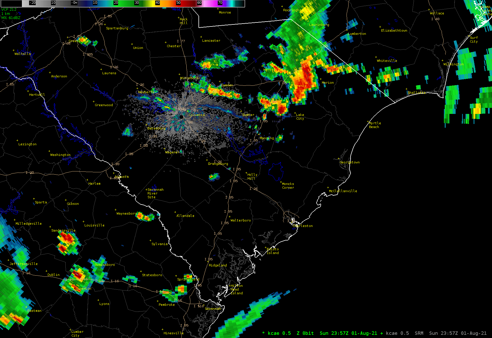
We’ve seen showers and thunderstorms essentially split the area so far today; severe thunderstorms with even a few tornado-warned cells fired up in North Carolina, while a separate round of convection has been ongoing in far southern Georgia into Florida. This has kept the Charleston Metro Area fairly quiet, but I suspect that will be changing fairly soon as a frontal boundary continues its southward trajectory across the state. Radar is doing a good job at picking out an outflow boundary cutting through the Midlands right now, which has caused storms to fire in the Columbia metro area.
This outflow boundary is approaching a few smaller popup storms in Orangeburg and northern Berkeley counties. The atmosphere over Charleston continues to be fairly ripe for thunderstorm development, and short-term models continue to indicate additional shower and thunderstorm coverage developing in the I-95 corridor by 10PM. With the loss of daytime heating, instability has been waning, but there is still more than enough fuel for some loud and rainy thunderstorms in spots tonight.
The front helping to drive all this will stall out across the area tomorrow. With plenty of available moisture and instability, we’ll see several rounds of showers and thunderstorms over the next few days. I’ll have more details in another post later this evening.
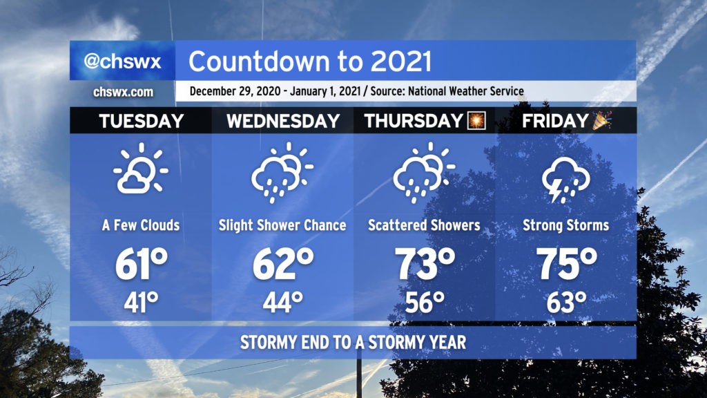
2020 looks to hand off to 2021 in the fashion we would expect from this year — a bit on the warm and stormy side — as a cold front approaches the area from the west.
The last few days of the year will get progressively warmer, with 70s back in the picture for New Year’s Eve. Rain chances also return beginning Wednesday, with a shower or two possible as a coastal trough moves inland in response to high pressure to the northeast breaking down and moving out. Rain chances improve for Thursday along with a noticeable jump in temperatures (70s!) as warm and moist air overspreads the area ahead of our next storm system.
Overall, if you’ve got things to do outdoors, Tuesday’s your best day to for-sure avoid rainfall. As for New Year’s Eve, I’m not expecting a washout for fireworks displays as of now, but the devil is in the details. Stay tuned.
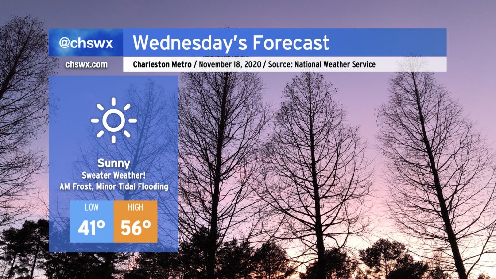
Get your sweaters ready — Wednesday is going to be a chilly one. A dry cold front featuring a reinforcing shot of cold air will swing through the area tonight. By tomorrow morning, winds will be back out of the north and a little breezy — lows in the low 40s may feel closer to the mid-30s when factoring the wind in. Despite full sunshine, temperatures will only rise into the mid-50s given continued cold advection into the area.
As high pressure slips overhead Wednesday night, winds will calm and skies will remain clear, allowing for excellent radiational cooling conditions. We may be contending with some frost as we get into overnight Wednesday/early Thursday morning, especially in the inland tier of counties. Keep an ear out for a possible Frost Advisory from the National Weather Service, and be ready to ensure plants, pets, and people are protected. (Pipes will be okay — not expecting a freeze just yet.)
What’s clear about Monday is that, at some point, there will be a squall line with strong thunderstorms coming through the area. These storms will be capable of producing wind damage and could spawn a tornado or two along the leading edge of the line.
The degree to which this threat will materialize is going to be highly dependent on timing, and that’s where it gets tricky — but I’ll do my best to demystify it.
While much of the nation will close October out with fairly cold temperatures, a sliver of warmth will hug the East Coast, keeping temperatures closer to late September/early October normals for the work week. Upper-level disturbances will keep the weather rather unsettled as well, with rain chances Tuesday-Friday before a cold front ushers fall back into the picture for the weekend.
Another cold front will be moving through the area on Tuesday, bringing along some more fall-like weather for Wednesday and beyond. Before it passes, though, we’ll see temperatures spike into the mid-80s with scattered thunderstorms in the area. A few thunderstorms could produce strong, gusty winds in the late afternoon/early evening hours. Be alert to possible warnings.
The front is expected to clear the area around sunset or a little later. Temperatures will cool down nicely behind said front, bottoming out in the low 50s for Wednesday morning.
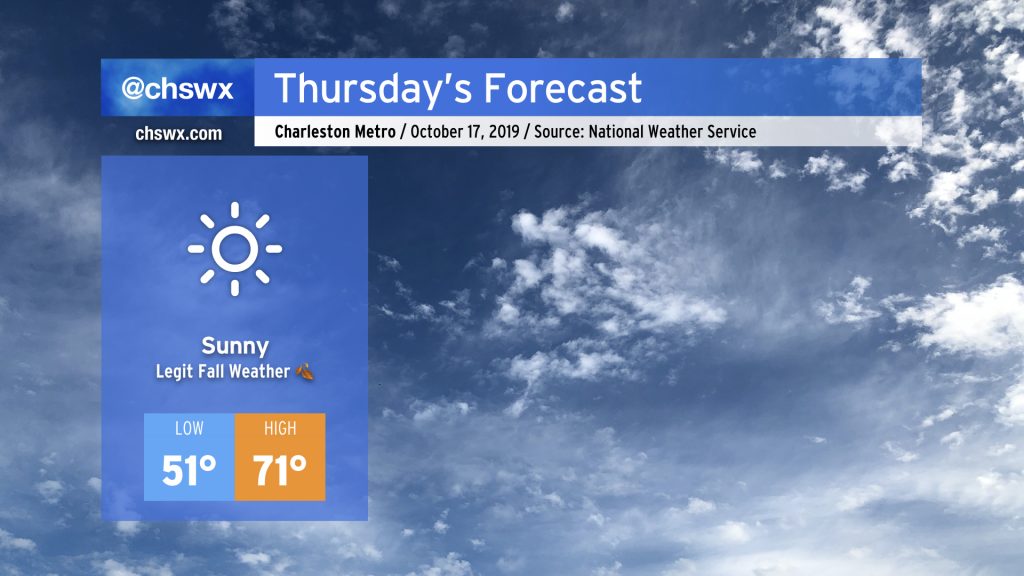
After the wettest day since Dorian, a ridge of high pressure will usher in fall weather for a few days, with the potential for the first 40° readings of the season Thursday and Friday mornings. Then, a slug of tropical moisture will bring in another solid rain chance late this weekend into next week.