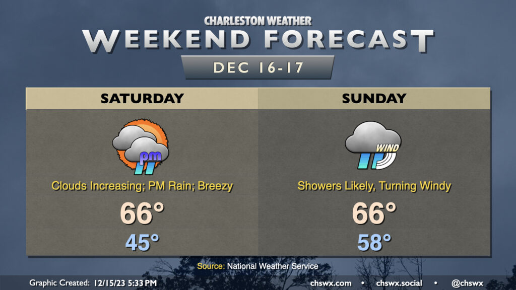
Weekend forecast: Turning breezy and rainy; storm peaks Sunday
A nor’easter will make this second-to-last shopping weekend before Christmas a little tricky, with heavy rain, gusty winds, and coastal flooding all coming into play, especially on Sunday.
Saturday: Turning unsettled
Saturday starts innocuously enough with lows in the mid-40s — a few degrees warmer than we started the past couple days — and will warm to the mid-60s as warm and moist air starts to take residence across the area. We should start the day rain-free, which will be helpful in case you have holiday decorations you need to stow (particularly those of you near the coast where winds will be strongest). Showers will begin to build in from the south as we head into Saturday afternoon, and by evening we should be in the rain. There will be periods of heavy rain at times as we get into Saturday night, though the risk for flooding appears low. Winds will be increasingly breezy as well, with gusts approaching 25-30 MPH at times.
Sunday: Heavy rain, gusty winds, coastal flooding
Rain and wind will intensify as we get into Sunday morning, when the low makes its closest approach. Gusts 30-40 MPH will be likely at and near the coast (and I just don’t think we can rule out some 50+ MPH readings either). Further inland, gusts could still reach 30+ MPH, especially near Lake Moultrie. I certainly can’t rule out some sporadic power outages, especially where the higher gusts occur.
A heavy band of rain — and maybe even a few embedded thunderstorms if the convection-allowing models are correct — will be moving into the area before daybreak, and it’s within this band where the bulk of the rain should occur. Generally speaking, it appears that much of the area should receive 2-3″ with locally higher amounts between Saturday night through midday Sunday.
Severe weather appears unlikely, though if some surface-based instability can creep ashore, low-level shear will certainly be there for a few rotating cells. The risk of this is quite, quite low, though. For its part, the Storm Prediction Center has the SC coastal corridor in a marginal severe weather risk on Sunday.
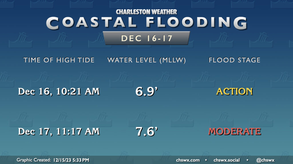
We’ll need to watch water levels closely late Sunday morning for the potential for moderate coastal flooding. High tide is expected to peak around 11:17am, and water levels should be topping out around 7.5-7.7′. If heavy rain is ongoing near this time, there could be an elevated risk for flooding in parts of downtown Charleston outside of where salt water typically reaches. Be aware of this potential if you have plans downtown Sunday.
After midday, we should start to see the heaviest rain begin to lift out as the low pressure center moves north of the area. Showers should continue to hang around through at least Sunday evening. Models are still a little mixed on the exact timing of the rain’s departure, but overall, we should expect to be rain-free by Monday morning. Winds will shift around to the northwest and should still be strong as we head into the evening, though they will be diminishing as the low moves further away. After the low clears out, a frigid airmass looks to move back into the area — we may not get out of the 40s on Tuesday!
Stay close to weather updates throughout the weekend, and remember, we’ve done this before — we will be just fine.
Follow my Charleston Weather updates on Mastodon, Bluesky, Instagram, Facebook, or directly in a feed reader. Do you like what you see here? Please consider supporting my independent, hype-averse weather journalism and become a supporter on Patreon for a broader look at all things #chswx!