Weekend forecast: Unsettled weather returns
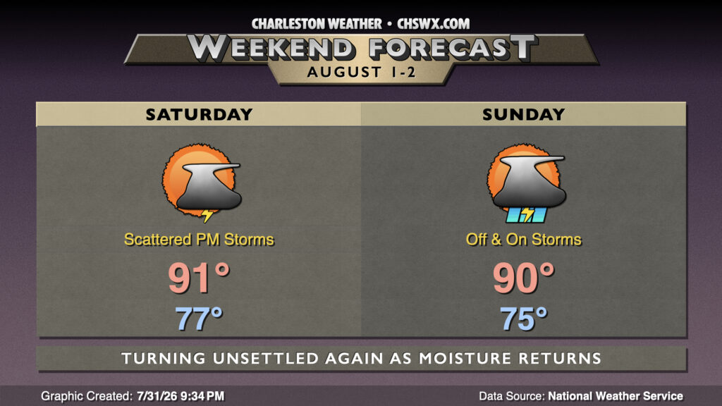
High pressure will give way to a cold front approaching from the west, bringing more humid air and shower and thunderstorm chances back to the forecast for the weekend.
Read more »High pressure will give way to a cold front approaching from the west, bringing more humid air and shower and thunderstorm chances back to the forecast for the weekend.
Read more »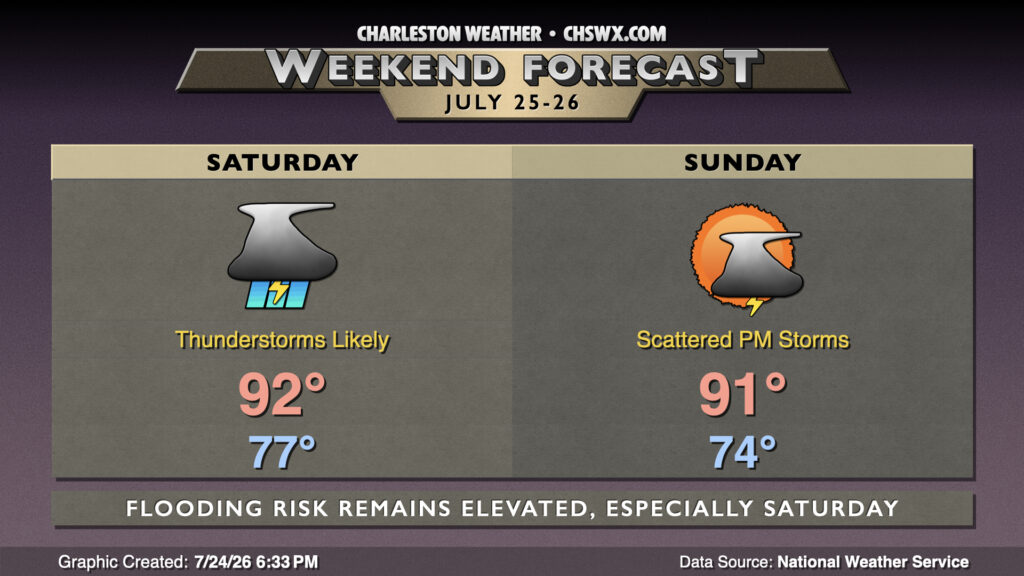
A stalled front will continue to contribute to shower and thunderstorm chances through the weekend, particularly on Saturday as a trough aloft swings through, providing a little extra “oomph” to budding updrafts aspiring to be efficient rain-makers.
Read more »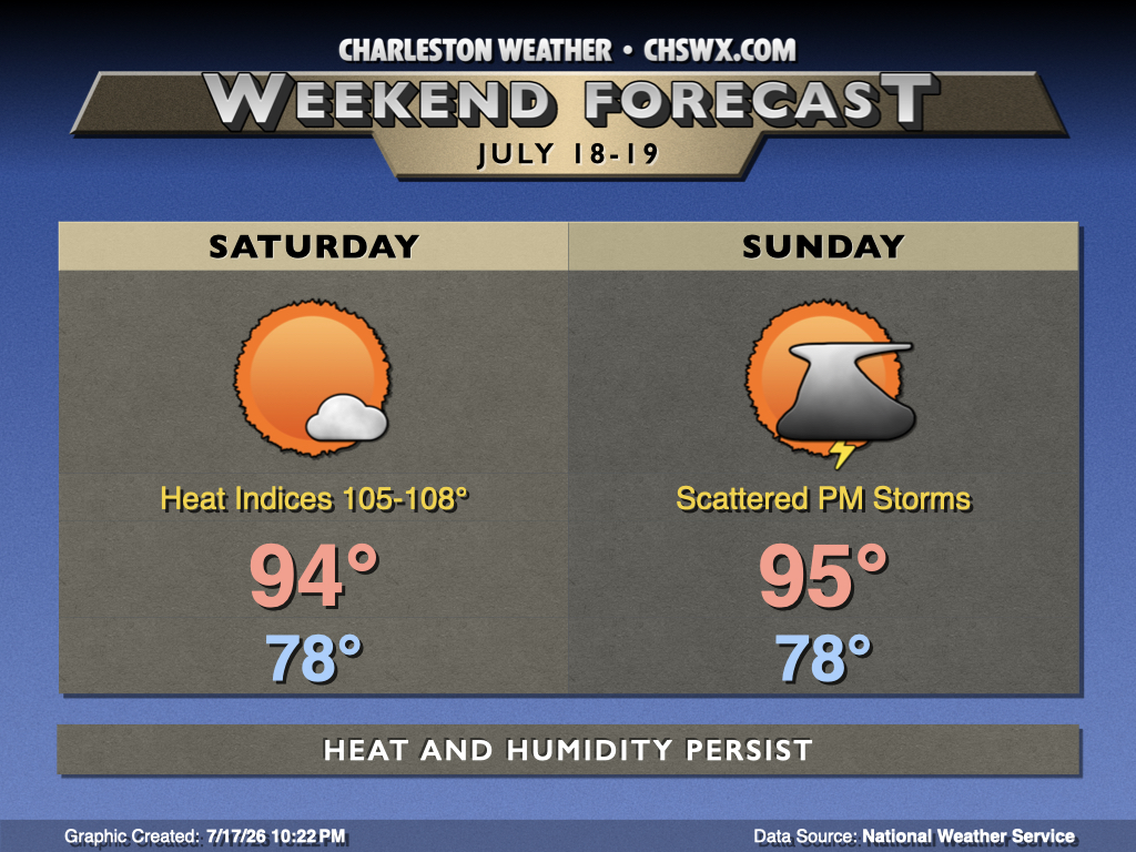
Midsummer heat and humidity will not relent this weekend with temperatures continuing to run above normal courtesy of Atlantic high pressure pumping warm and moist air into the area while high pressure remains resident aloft for a few more days.
Read more »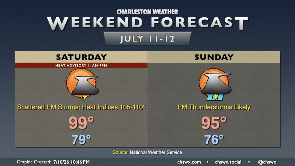
After another 99° day at the airport, we’ll take one more run at the century mark on Saturday before a front drops toward the area on Sunday, bringing about more unsettled weather that will keep temperatures a little more in check.
Read more »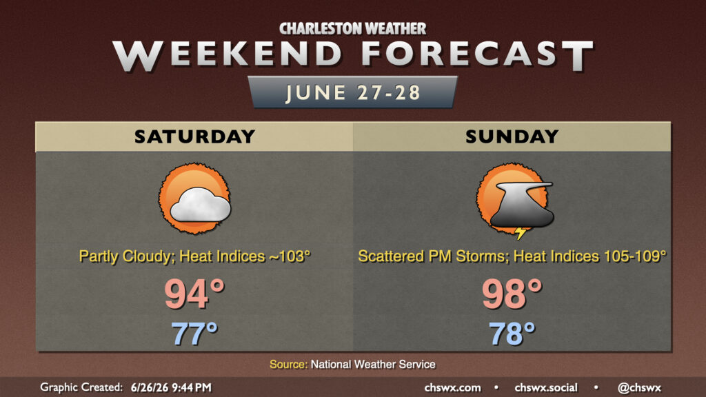
A hot weekend is ahead, especially on Sunday, as high pressure builds in aloft. A few of us could get some relief from a few thunderstorms, but that’s not a guarantee for everyone.
Read more »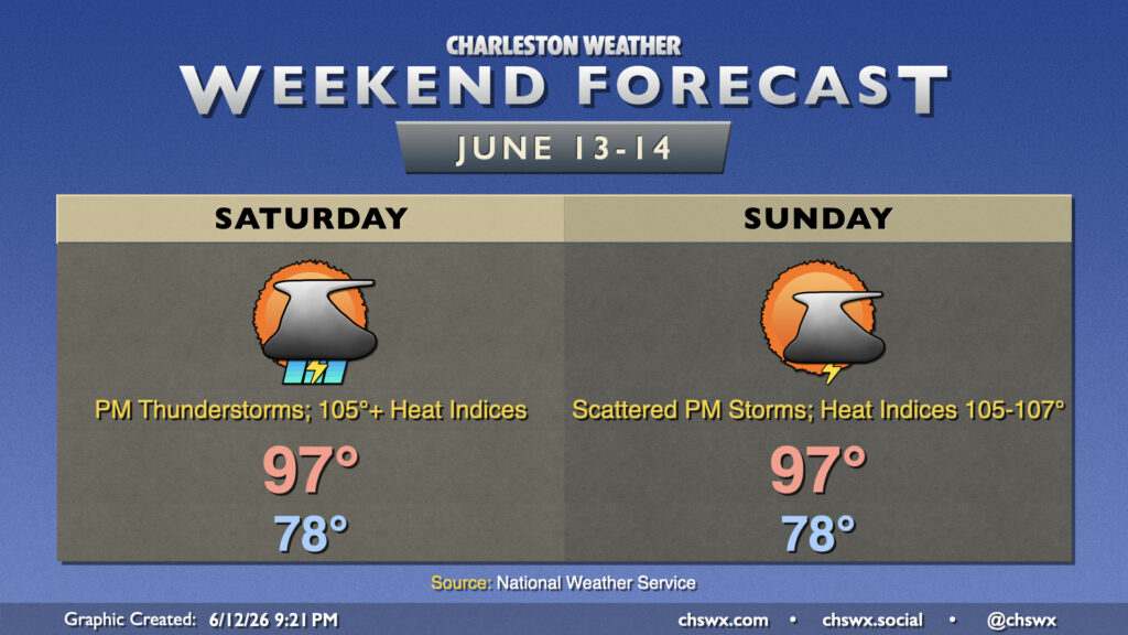
Heat, humidity, and chances for afternoon thunderstorms continue into the weekend, with the potential for not only record high temperatures but also record warm low temperatures each day.
Read more »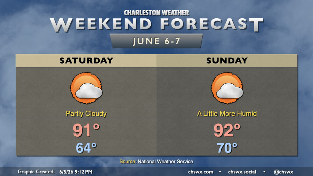
This weekend will be warm and a little more humid as surface high pressure moves into the Atlantic, sending winds more southerly behind it which turns the moisture tap back on. We should stay quiet, though, with ridging aloft and a pretty solid pocket of dry air hanging in there for a couple more days. We’ll see some clouds at times, particularly of the high variety, but otherwise expect plenty of sunshine to still break through for the weekend. Temperatures Saturday start in the mid-60s, warming to the low 90s in the afternoon, while Sunday feels much more like summer with a low around 70° and highs in the low 90s.
Rain chances gradually return as we get into the start of next week; these will generally be of the popup variety. Highs Monday top out in the mid-90s, while upper 80s to around 90° will be more common through the middle of next week.
Rain spreads back into the Lowcountry on Saturday as a stationary front buckles back northward across the area. A bit of upper-level energy will also kick in some lift, and that’ll result in scattered to numerous showers and thunderstorms at times on Saturday. Right now it looks like the best chances will be found in the morning through early afternoon hours, but a shower or storm just can’t be ruled out during any part of the day. Temperatures will start in the low 70s, warming to the mid-80s in the afternoon at best.
Read more »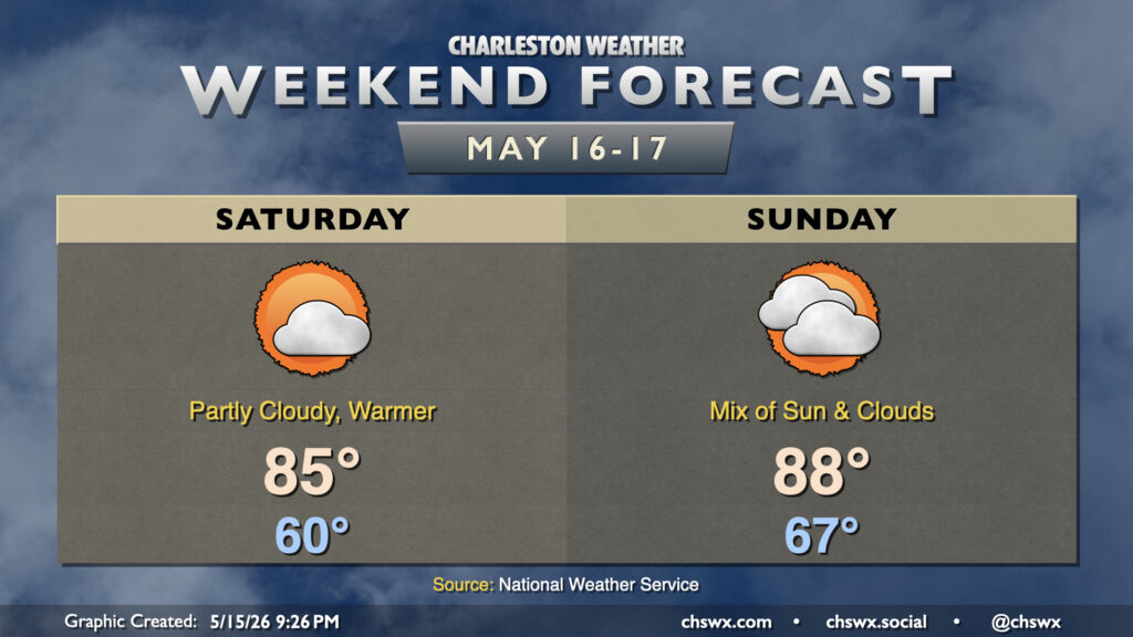
We’ll turn warmer over the weekend as high pressure aloft and at the surface remain the main weather features. With high pressure moving offshore, winds out of the south and southeast will bring warmer and somewhat more humid air into the area. This will contribute to a little more in the way of cloud cover, but despite that cloud cover, highs still peak in the mid-80s. Clouds thicken in the mid and upper levels on Sunday, but that doesn’t stop temperatures from running in the upper 80s in the afternoon. Shouldn’t see any rainfall, though, as the better moisture and rain chances will be well, well inland. Not excellent for the ongoing extreme to exceptional drought across parts the Lowcountry.
Read more »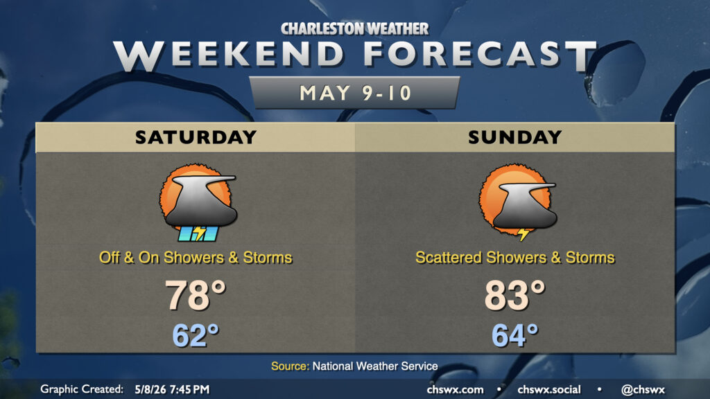
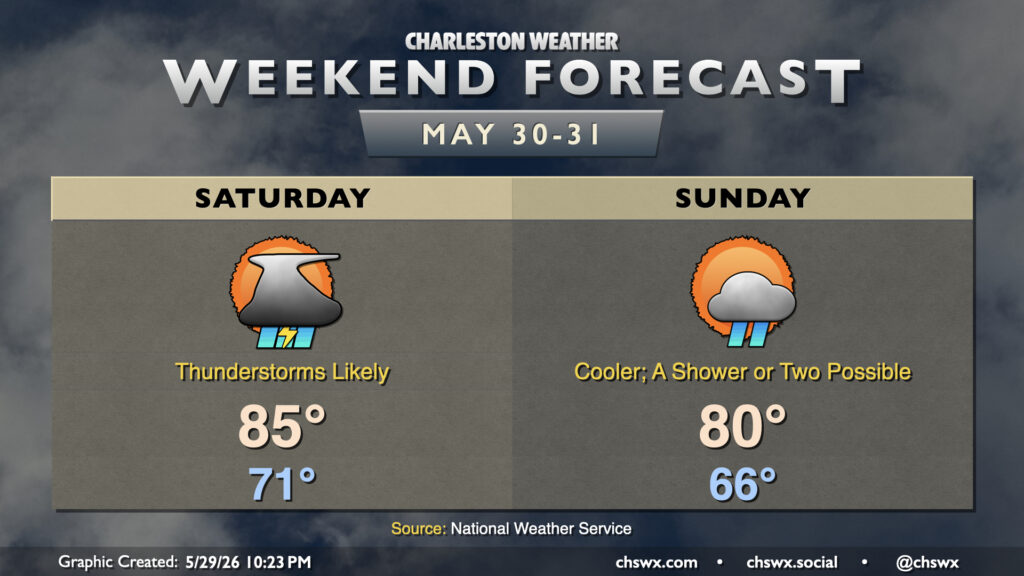
Showers and a few thunderstorms return to the weather picture this weekend as disturbances aloft ripple across the area. The good news is that it won’t rain all the time and that whatever rain we will get will help with the ongoing severe drought.
Read more »