The week ahead: Periodically unsettled and warm
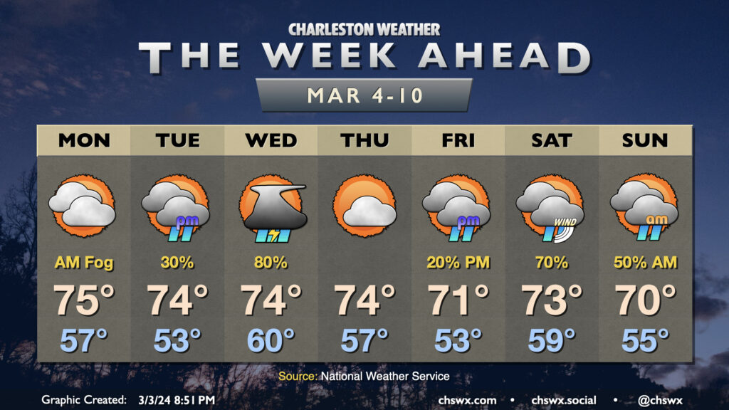
Well, it will certainly feel like climatological spring this week as we stay on the warm side of normal for early March with a couple storm systems dropping through at times. First, though, we’ll get off to another potentially foggy start Monday morning as lows dip to the mid-50s. Fog should dissipate by mid-morning, and we’re looking at another warm day in the mid-70s under a mix of sun and clouds as high pressure asserts itself a bit more.
We stay rain-free for the majority of Tuesday, though shower chances return late in the day as the next storm system advances on the area from the west. Low pressure will develop and move across Georgia and the Carolinas on Wednesday, driving a front through the area which should kick off a decent bit of showers and maybe a few thunderstorms as well. As is often the case, shear is decent but instability is lacking, which should put a governor on any severe weather threat. Temperatures will once again run well on the warm side of normal, starting around 60° and warming to the mid-70s ahead of the front. Current timings indicate that showers and thunderstorms should be done by early afternoon, with quieter and clearing weather to follow. Winds will turn a bit gusty as the front moves by, though.
We stay quiet on Thursday as high pressure briefly builds into the area before the next storm system arrives later Friday and into the early weekend. Looks like, at least right now, we take the brunt of the next storm system on Saturday with another round of showers and maybe a thunderstorm or two. Rain chances linger into early Sunday, though we should overall see improvement as the day goes on.
Programming note: On hiatus until Sunday
Regular posts and the Charleston Weather Daily Podcast will be on hiatus through Sunday as I attend to business matters. You can still get @chswx automated alerts, though, via the @chswx Alerts Mastodon feed. A subset of the most critical alerts will auto-post to Bluesky if you’re following there. Alas, X is still not really playing ball with reliable and affordable API access, so that continues to be a limiter for that platform.
Finally, you can always find the latest National Weather Service zone forecast for the Charleston metro on the homepage of this very website. Weather alerts populate there, too, though don’t auto-push to devices (yet, anyway).
See y’all again on Sunday!
Follow my Charleston Weather updates on Mastodon, Bluesky, Instagram, Facebook, or directly in a feed reader. Do you like what you see here? Please consider supporting my independent, hype-averse weather journalism and become a supporter on Patreon for a broader look at all things #chswx!