Friday & the weekend: A couple more flirtations with 100° before (cooler) changes arrive
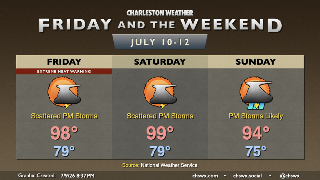
Charleston International Airport hit 100° today. It’s the first century-mark temperature reading there since May 29, 2019. There will be a couple more opportunities to get back there before the pattern changes to something more unsettled and cooler late this weekend into next week.
FIrst, though, we’ve got another round of high heat for Friday. It’ll be a third straight day under an Extreme Heat Warning for Charleston and southern Berkeley counties (Daniel Island, Hanahan), with a Heat Advisory elsewhere in the Tri-County. Heat indices will head toward 110° at many spots by early afternoon, and as the seabreeze gets going, the resulting dewpoint surge behind it will send heat indices closer to 113-115°, especially in the Highway 17 corridor.
A few storms could pop on the seabreeze in the afternoon, though guidance was a bit aggressive for today and storms ultimately struggled to develop. Still, you’ll want to keep an eye out for quickly changing conditions after 2PM.
The height of the heat wave concludes on Saturday. We’ve got another shot at reaching 100° in the afternoon in some spots after another balmy start in the upper 70s to low 80s. There is a little better chance for showers and thunderstorms to develop on the seabreeze in the afternoon, though, so hopefully. more of us will get some relief from the heat. We’ll just need to be mindful of the risk for heavy downpours, frequent lightning, and a sporadic damaging wind gust or two.
Changes begin Sunday as a front tries to drop in from the north. This will keep more cloud cover in place, limiting temperatures to the low-to-mid-90s in the afternoon before showers and thunderstorms develop later in the afternoon and into the evening. Most of us should get some rain out of this, but if you don’t, rain chances will remain elevated into the first part of next week, and coverage should be a bit more widespread in character rather than hit-or-miss.
Follow my Charleston Weather updates on Mastodon, Bluesky, Instagram, Facebook, or directly in a feed reader. Do you like what you see here? Please consider supporting my independent, hype-averse weather journalism and become a supporter on Patreon for a broader look at all things #chswx!