Jared Smith founded @chswx on Twitter in 2008 as an experiment in disseminating weather data through social media. In the ensuing decade-and-a-half, @chswx has provided live coverage of tropical cyclones, tornadoes, severe weather, and even a couple bouts of winter weather to the good people of Charleston, SC.
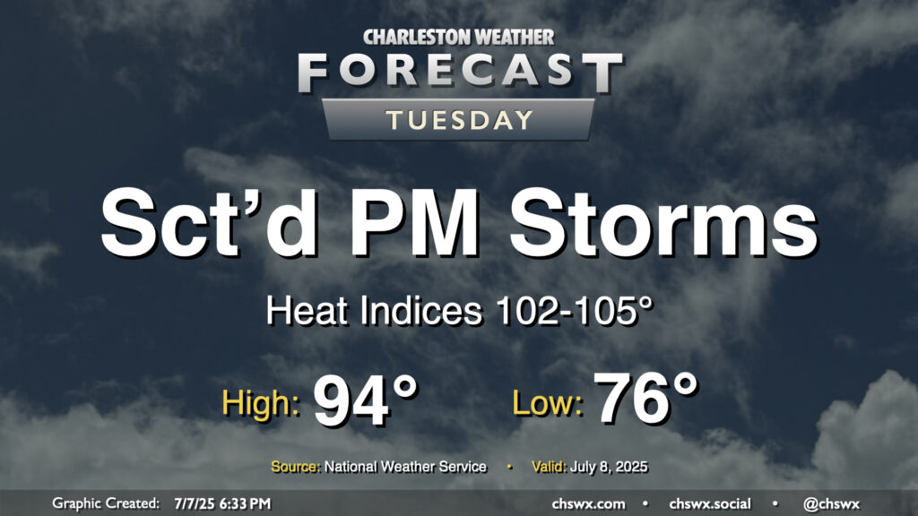
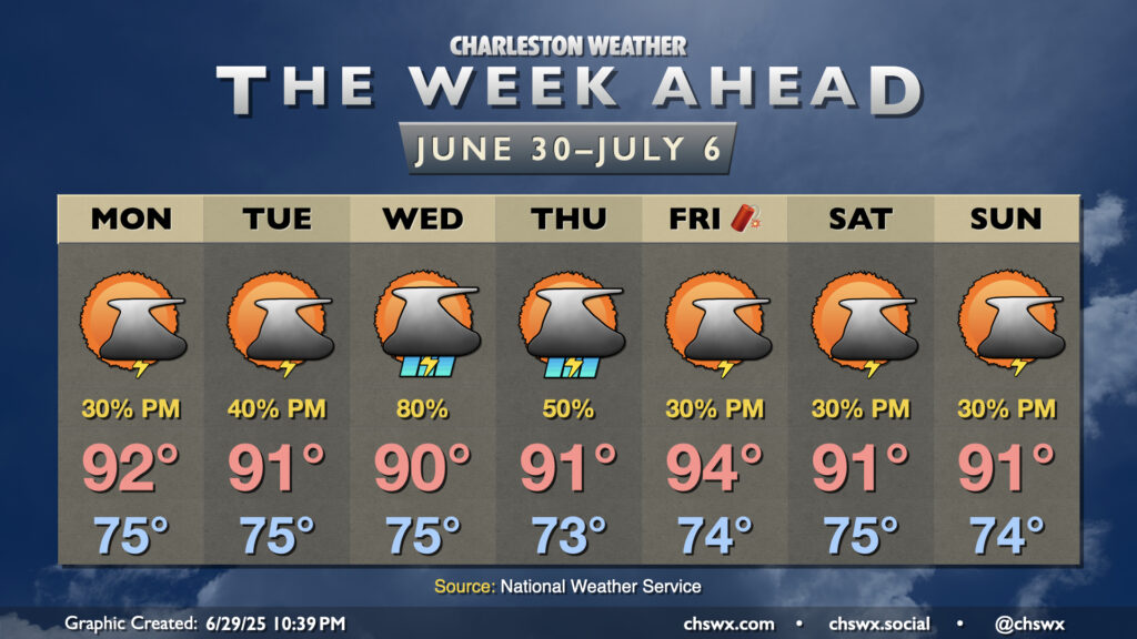
It’ll be another hot and humid July day across the Lowcountry on Tuesday as high pressure at the surface and aloft remain the predominant weather features, at least for one more day. The morning starts in the mid-70s inland to near 80° at the coast and downtown, warming to the mid-90s once again in the afternoon. Heat indices should rise in the 102-105° range, especially in the immediate wake of the seabreeze thanks to the dewpoint surge that typically accompanies it. We should see showers and thunderstorms fire along and ahead of the seabreeze by afternoon. Storms that fire could dump a good bit of rain in some spots in a short period of time thanks to the tropical airmass left behind by Chantal, so we will need to monitor for the potential for minor flooding in poor drainage areas. A stronger storm or two can never be ruled out this time of year, either, with gusty winds the main concern.
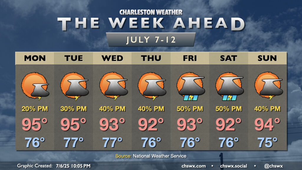
After a Chantal-cooled weekend that saw our 21-day 90° streak come to an end, this upcoming week will once again feel very much like…well, July, as temperatures soar back to the mid-90s, especially for the first half of the week, with afternoon thunderstorm chances each day.
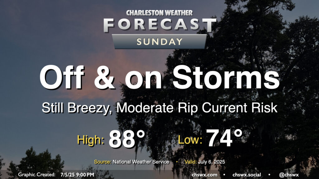
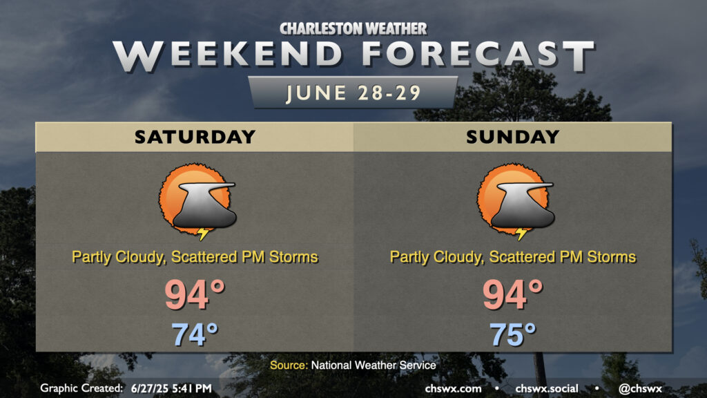
Tropical Storm Chantal will make landfall overnight somewhere between Georgetown and Myrtle Beach, keeping the risk for some showers around overnight into Sunday. We should see an uptick in shower and thunderstorm activity as the heating of the day helps to wring out some wrap-around moisture on the southwest side of Chantal’s circulation. Overall, though, this storm hasn’t been a major rainmaker for the area, and that shouldn’t change much on Sunday with the scattered nature of the individual showers and thunderstorms. Severe weather is not expected as we sit within the weaker side of Chantal’s circulation, but the risk for rip currents will continue and we should still have some breezy conditions at the beaches and on the bridges. Temperatures will start in the mid-70s again, but highs should stay below 90° for one more day with the clouds and rain in the area (though we should see a decent amount of sun between showers, too).
By the way, our 90° streak ended today at 21 days — the high at the airport topped out around 85°. Don’t worry, though — we’ll kick off a new streak starting Monday, and temperatures for the upcoming work week will certainly have that July feel to them, complete with Advisory-level heat indices.
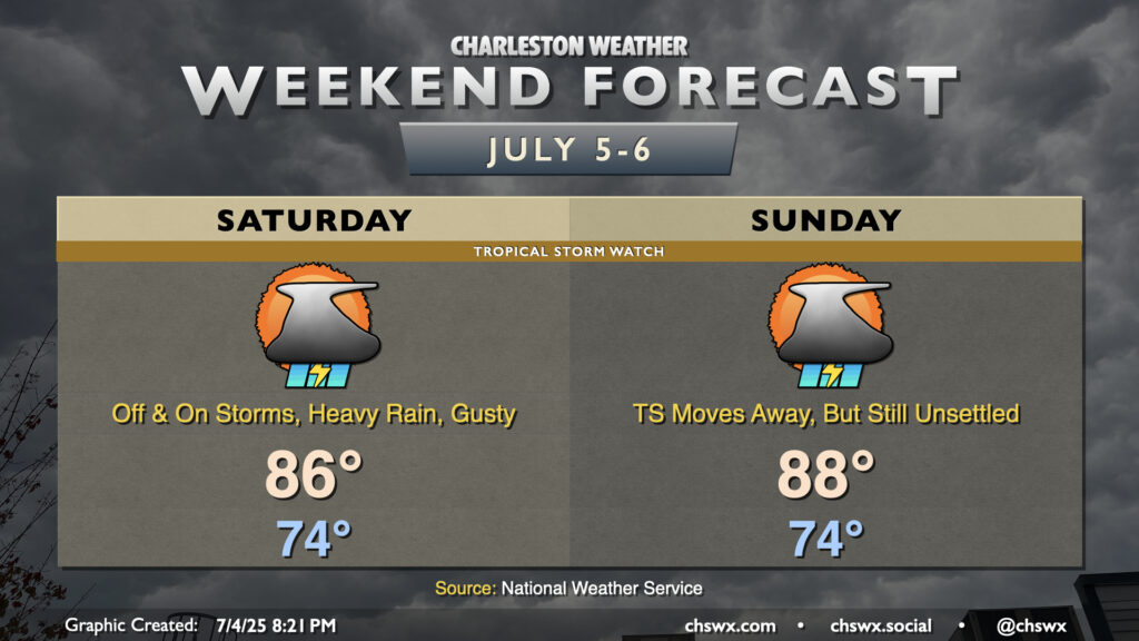
Tropical Depression Three developed this afternoon off the Southeast coast, and will be the main driver of our weather this weekend. Even though Three is forecast to become Tropical Storm Chantal, this should largely be a beneficial system, bringing some rain to some parched spots. However, it will still bring a few hazards, including gusty winds (40-45 MPH) near the coast and offshore, a high risk of rip currents, and the potential for locally heavy rain that could lead to some flooding, particularly around the afternoon high tide. This potential has prompted a Tropical Storm Watch for Charleston County. With all that said, though, this is nothing we can’t handle.
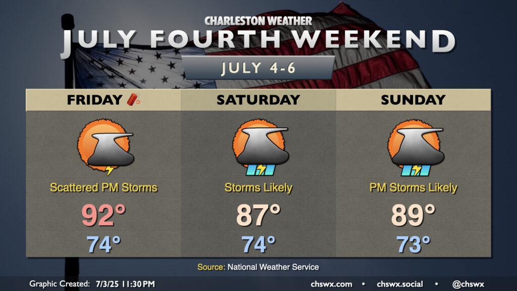
The weather for the Fourth of July weekend looks a bit on the unsettled side as low pressure — perhaps tropical in nature — spins up offshore and increases the risk for rain near the coast.
Independence Day itself looks okay with a bit of drier air working into the area in the wake of a stalling front. There’s still enough juice for a few thunderstorms along and ahead of the seabreeze in the afternoon, so be sure you have indoor alternatives to your outdoor plans just in case thunderstorms threaten. Temperatures start in the mid-70s, warming to the low 90s in the afternoon. Heat indices will run in the mid-90s to around 100° in the afternoon, particularly in the immediate wake of the seabreeze, so be wary of the heat especially if you are more vulnerable to it.
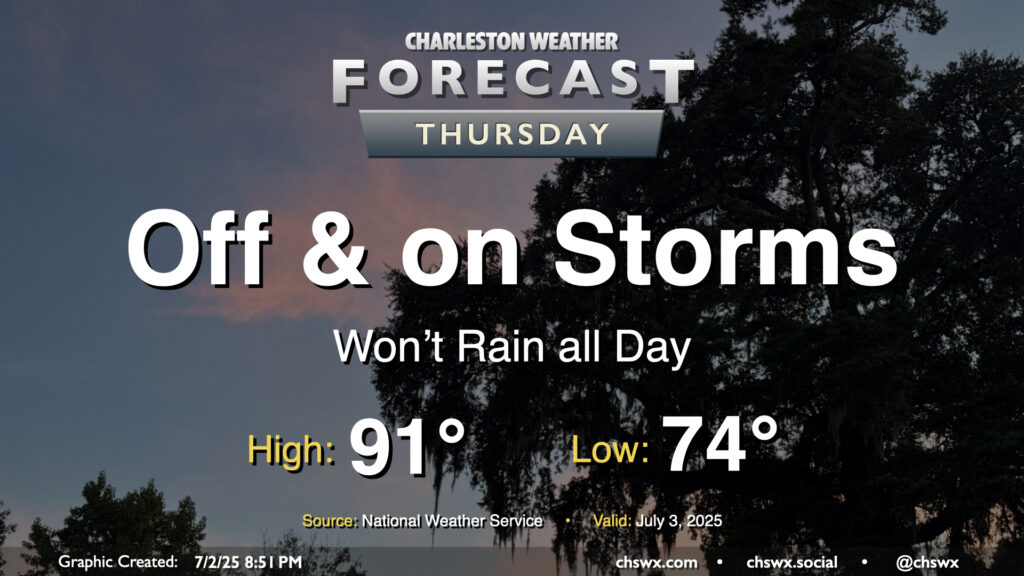
While storms so far on Wednesday were more off than on, more chances for rain arrive on Thursday with the heating of the day and a stalling front that will be in the neighborhood. Temperatures start in the mid-70s, warming to the low 90s in the afternoon — right on the line for what to expect from early July. Showers and thunderstorms will be capable of heavy rain and frequent lightning, and an isolated severe storm can never be ruled out this time of year where boundaries collide.
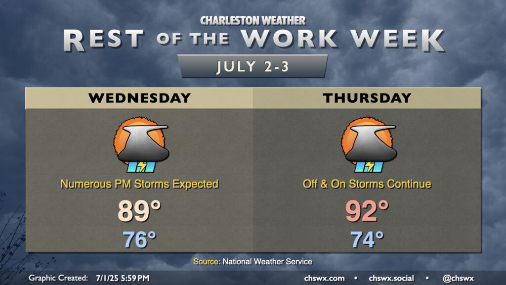
A cold front will draw nearer to the Lowcountry on Wednesday before stalling out, which will help kick up the risk for thunderstorms especially during the afternoon and evening hours. It won’t rain all day, but many of us should measure some rainfall as storms push across the area from west to east through late night. Temperatures in the mid-70s will warm to the upper 80s to around 90°. There’s a chance our 18-day streak of 90°+ highs will come to an end thanks to the proliferation of cloud cover, showers, and thunderstorms on Wednesday, but we will see. Regardless, expect a steamy and eventually stormy day across the metro; be ready for rain to cause some slowdowns.
Thursday is looking a little better, though some storms could linger midday. But drier air will be moving in, and we should see improving conditions by evening. It’ll be another warm day, with highs returning to the 90s in the afternoon after another mid-70s start.
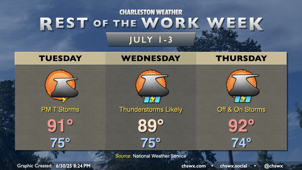
The rest of the work week will turn increasingly stormy as a cold front encroaches on the area by midweek. A trough aloft will help drive the front close to the area — but not quite through — and contribute to an influx in lift and moisture that’ll bring us scattered to numerous thunderstorms, particularly on Wednesday.
Warm, humid, and occasionally stormy days lie ahead to close out June and bring in July. (Side note: It’s insane that we’re entering the second half of 2025!) Temperatures look to remain in the 90s each afternoon, and if the forecast works out, the current 16-day streak of 90°+ high temperatures should continue through a third and into a fourth week (23 days, to be exact).
A cold front will approach the area on Wednesday into Thursday, stalling out before it reaches us (of course). This will increase the risk for showers and thunderstorms for those two days in particular, and if there’s a period that could impact that 90° streak, this is it. Regardless, it’ll still be steamy and stormy.
The final weekend of June will have that classic end-of-June feel: lows in the mid-70s, highs in the mid-90s, and isolated to scattered afternoon thunderstorms each day.