Jared Smith founded @chswx on Twitter in 2008 as an experiment in disseminating weather data through social media. In the ensuing decade-and-a-half, @chswx has provided live coverage of tropical cyclones, tornadoes, severe weather, and even a couple bouts of winter weather to the good people of Charleston, SC.
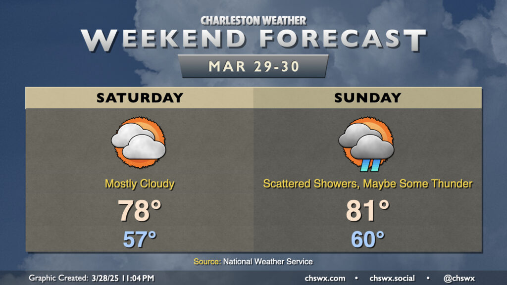
High pressure continues to gradually lose its grip on our weather over the weekend as the next storm system approaches the area. We do get a rain-free day in on Saturday, though, with a mild but mostly cloudy day. We start Saturday in the mid-to-upper 50s, warming to the upper 70s in the afternoon. Southerly winds will generally run around 5-10 MPH.
Shower chances increase for Sunday as some mid-level energy aloft moves its way into the area ahead of the approaching cold front, stirring up some scattered showers and maybe some thunderstorms at times perhaps throughout the day. It won’t be a washout, but you’ll want to keep an eye on the sky as some rain and thunder will be possible from time to time. It’ll be a rather warm day, with lows around 60° warming to the low 80s in the afternoon.
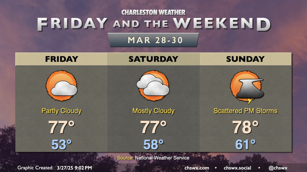
Quiet weather continues for a couple more days, albeit with high pressure slowly losing its grip over the area ahead of the next cold front. We’ll start to warm up as southerly flow develops over the area; expect to start Friday in the low to mid-50s, warming to the mid-to-upper 70s in the afternoon under partly cloudy skies. More clouds filter into the area for Saturday as a bit more in the way of humid air works its way in; expect a warmer start in the upper 50s with highs topping out once again in the mid-to-upper 70s, governed by the increased cloud cover.
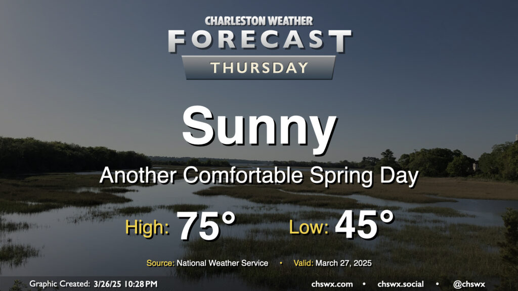
Another nice day is ahead for Thursday as high pressure slides by to our north. Temperatures start in the mid-40s, warming to the mid-70s under sunny skies for one more day. With the center of high pressure shifting more north of the area, winds will swing around more to the northeast and the east. It’ll be another dry day, relative humidity-wise, especially away from the coast as dewpoints mix down to the 30s in the afternoon. An inland-moving seabreeze will send dewpoints up into the low 40s as we get later into the day, but it’ll still feel quite comfortable outside.
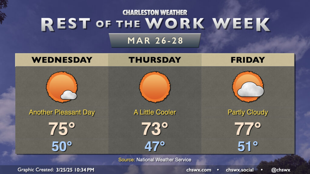
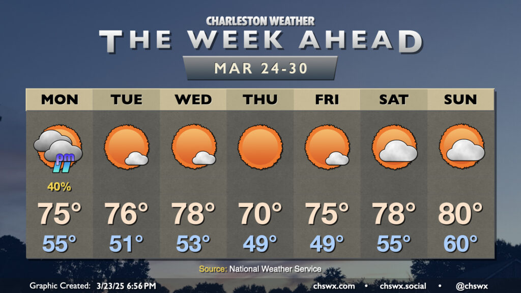
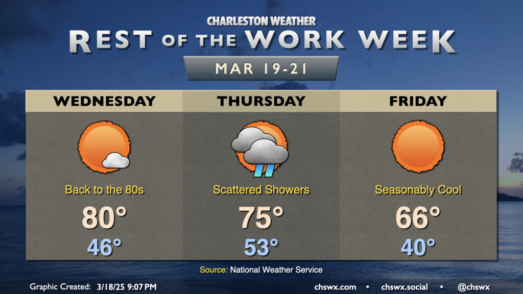
Quiet weather continues for the rest of the work week as one dry front slips through followed by another area of high pressure. Despite the frontal passage, winds out of the northwest will keep Wednesday a bit more on the warm side as highs head to the mid-70s after a start right around 50°. It’ll be a touch breezy, but nothing too horrendous (though we’ll need to mind relative humidities and any stronger gusts for possible enhanced fire danger).
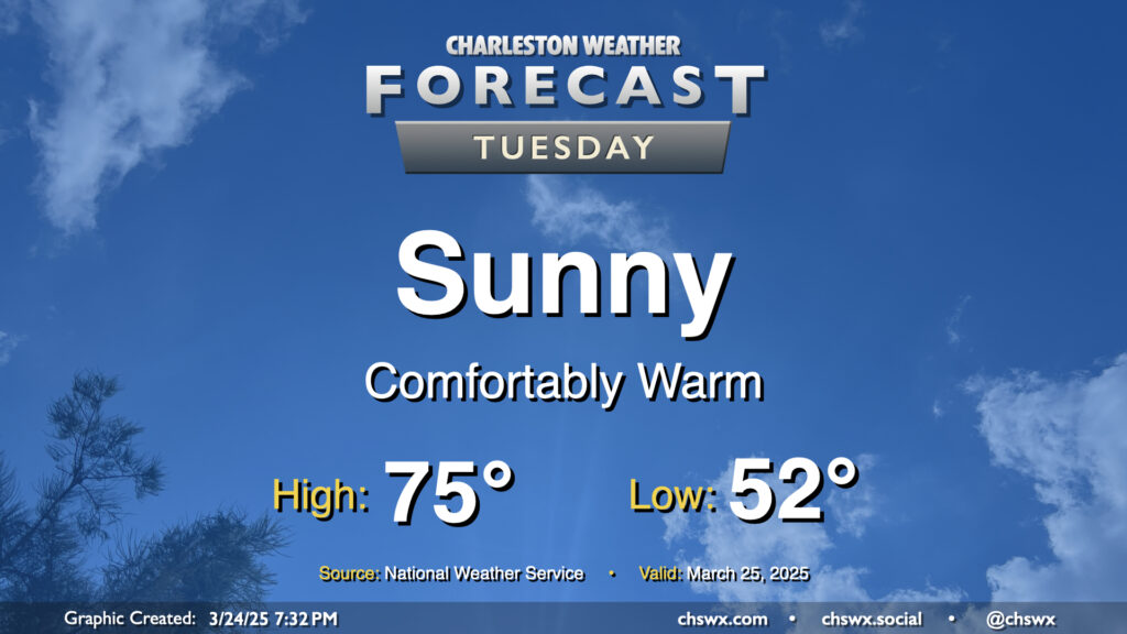
After a front swings through late Monday, quiet weather takes root for the rest of the week starting Tuesday. And what a nice day of weather Tuesday will bring: after starting in the low 50s, temperatures warm into the mid-70s in the afternoon with plenty of sunshine and low humidity. Once again, a shame the pollen is such a thing this time of year, because it’s looking like a beautiful day to get out and about where you have opportunities to do so.
There’s not too terribly much to write home about (weather-wise, anyway) this first full week of astronomical Spring as a series of high pressure systems generally run the show. However, there will be a front approaching with enough moisture return ahead of it for some showers on Monday afternoon. We’ll start Monday in the mid-50s, warming to the mid-70s before showers arrive. Showers shouldn’t be terribly heavy, though a few rumbles of thunder aren’t out of the question with a little elevated instability around. No severe weather is expected, though.
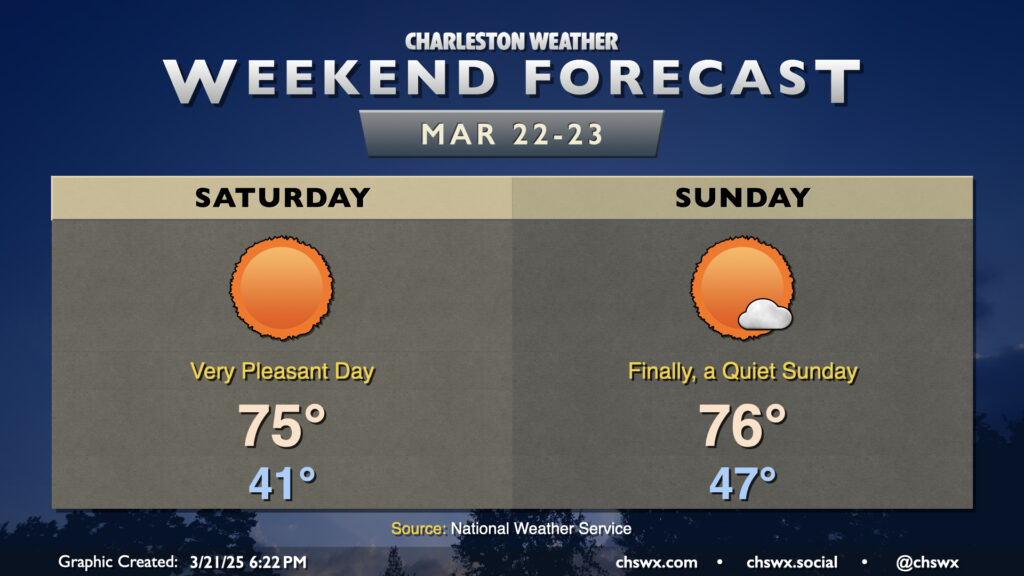
High pressure will be in control this weekend, yielding a beautiful couple days of weather across the Lowcountry. Saturday gets off to a slightly chilly start, with lows in the low 40s feeling a touch cooler with a little wind, but we’ll warm well into the mid-70s in the afternoon with lots and lots of sunshine. Dewpoints in the 30s will drive relative humidity values down to around 25%, making it feel fairly dry outside. The only fly in the ointment here will be a bit of an uptick in winds in the afternoon and evening hours, generally 10-15 MPH but with some higher gusts. This combined with the dry weather will lead to an increased fire danger, so please be careful if you must burn outdoors (and ideally just don’t do so).
Winds swing around a bit more southerly for Sunday, which will nudge dewpoints up into the 40s. It’ll still feel quite great outside, though, with lows in the mid-to-upper 40s warming back to the mid-70s in the afternoon under predominantly sunny skies once more. The slightly warmer dewpoints should bring the fire risk down a touch for Sunday, too. All in all, a really nice weekend lies ahead, and I hope you can take advantage. (Too bad about all the pollen, though.)
The next rain chance arrives with a front on Monday, but it’ll be short-lived, with quiet weather expected the rest of next week.
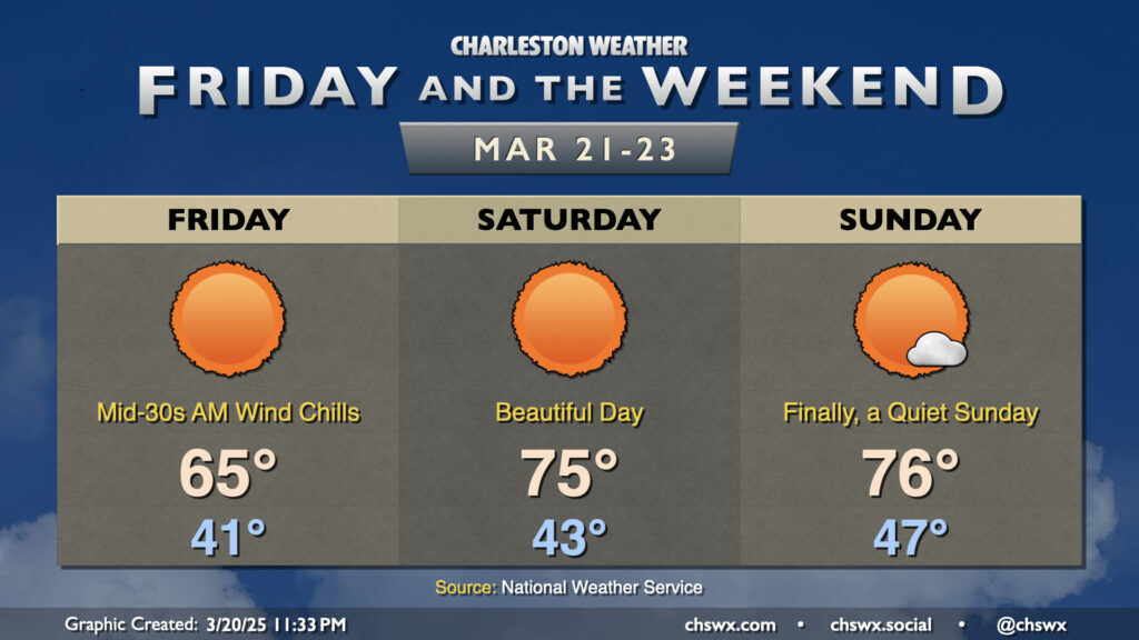
We’ve got a nice stretch of weather ahead for Friday and the weekend as high pressure rules the meteorological roost for a few days. Friday will start on a chilly note with lows in the low 40s feeling closer to the mid-30s thanks to elevated winds persisting through the morning. Temperatures Friday only top out in the mid-60s despite full sunshine owing the cooler and drier air continuing to push into the area.
The cool air advection shuts off on Saturday, though, and temperatures respond quite nicely to kick off one of the better weather weekends in a while. After another low-40s start, expect highs to peak right in the mid-70s in the afternoon with unfettered sunshine. And if you like Saturday, Sunday starts a touch warmer but ends up pretty much in the same place in the afternoon with highs in the mid-70s. Really, the only fly in the ointment is all the pollen — but such is life in March.
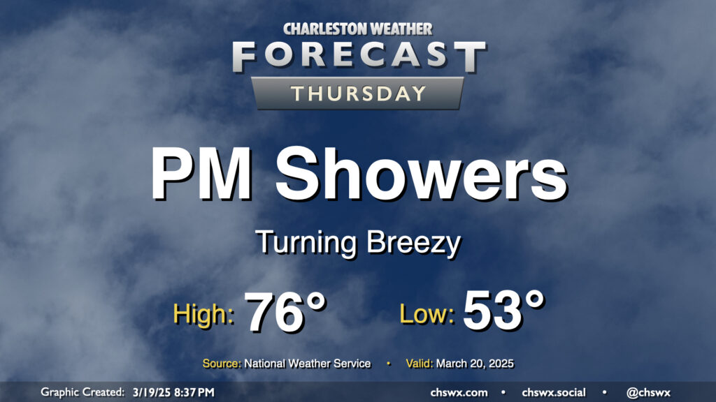
Showers return to the forecast on Thursday as a cold front moves into the area. We’ll get off to a comfortable start, with temperatures in the low-to-mid-50s to start the day. The front should show up later in the day, and we’ll get some rain-free time in, warming to the mid-70s before showers arrive. Model guidance brings the rain into the area by mid-afternoon and gets it through the area about 2-3 hours later. The rain won’t amount to much; about a quarter-inch at most. It’ll turn breezy as the front moves by, with gusts 20-30 MPH possible. Once it’s through, we’ll start to cool down heading into the overnight.
Warmth will peak Wednesday as high pressure slips offshore, sending winds back around to the south and highs up to around 80° in the afternoon under mostly sunny skies. We’ll see a few more clouds move in late as a cold front draws closer to the area, but Wednesday will remain rain-free.