Jared Smith founded @chswx on Twitter in 2008 as an experiment in disseminating weather data through social media. In the ensuing decade-and-a-half, @chswx has provided live coverage of tropical cyclones, tornadoes, severe weather, and even a couple bouts of winter weather to the good people of Charleston, SC.
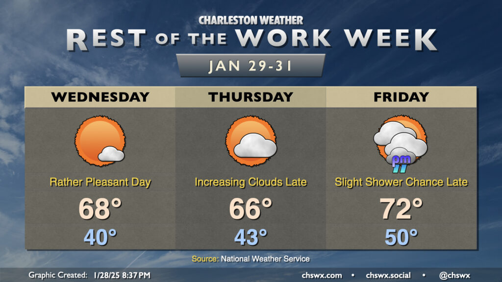
Warmer-than-normal temperatures will be the headline for the rest of the work week as high pressure ridges in a bit aloft. We’re still on track to see our first 70°+ reading of 2025 on Friday, too.
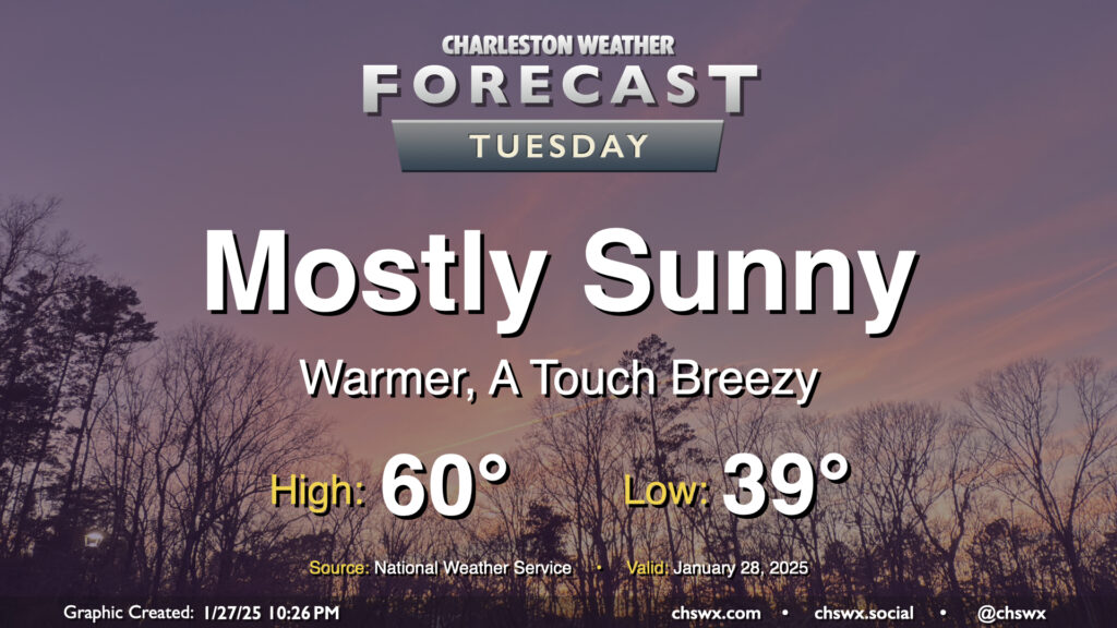
Tuesday will feel a lot better than Monday did as a front swings through with mostly a drier airmass, but not nearly as cold as the one we dealt with last week. We start the day in the upper 30s and warm to around 60° in the afternoon under mostly sunny skies. The black ice threat has ended, especially after Monday’s rain melted much of the rest of the snowpack and any lingering ice patches. If you have some snow left, it won’t be much longer, especially as we get into a warming trend this week.
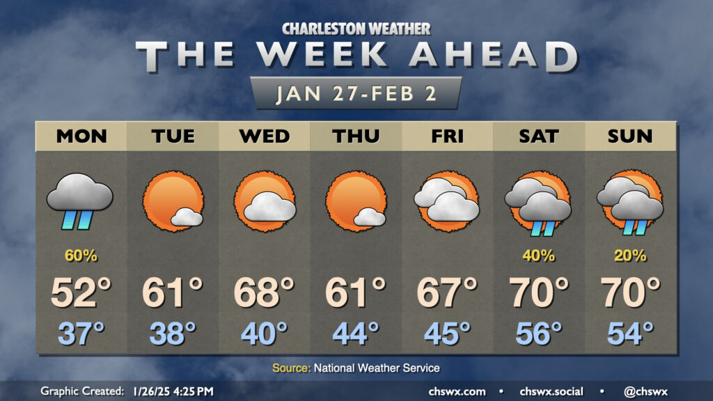
January will end much differently than how it has gone thus far as temperatures head around and even above normal to close out the month and bring in February with just a few rain chances mixed in to start and end the week.
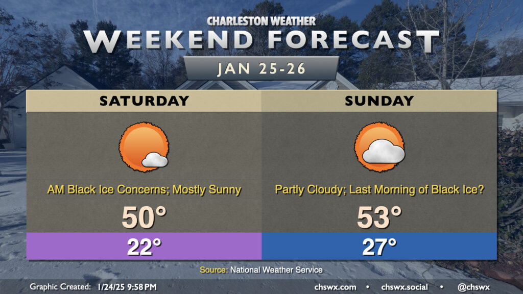
Snowmelt will accelerate this weekend with warmer temperatures and more sunshine each afternoon. We will still deal with freezing temperatures each morning, though, which brings the specter of black ice back to the forecast for a couple more days. Saturday morning looks particularly frigid, with clear skies, calm winds, and existing snowpack contributing to temperatures falling into the low 20s. Winds go southwesterly during the day Saturday, though, and temperatures will head to around 50° in the afternoon. With mostly sunny skies expected, we should get another solid day of melting.
Whatever’s left of the snowpack on Saturday probably won’t make it too far past Sunday. We start Sunday in the upper 20s, but once we head above freezing on Sunday morning, we’ll stay above for the foreseeable future. Temperatures will head to the mid-50s in the afternoon with a few more clouds in the mix. Despite a few more clouds, melting will continue apace. And with lows not expected to get below freezing overnight Sunday into Monday morning, the risk for black ice will come to an end.
The warming trend continues next week, especially starting Tuesday as highs return to the 60s for a few days for mid-week — a far cry from where we’ve been, that’s for sure!
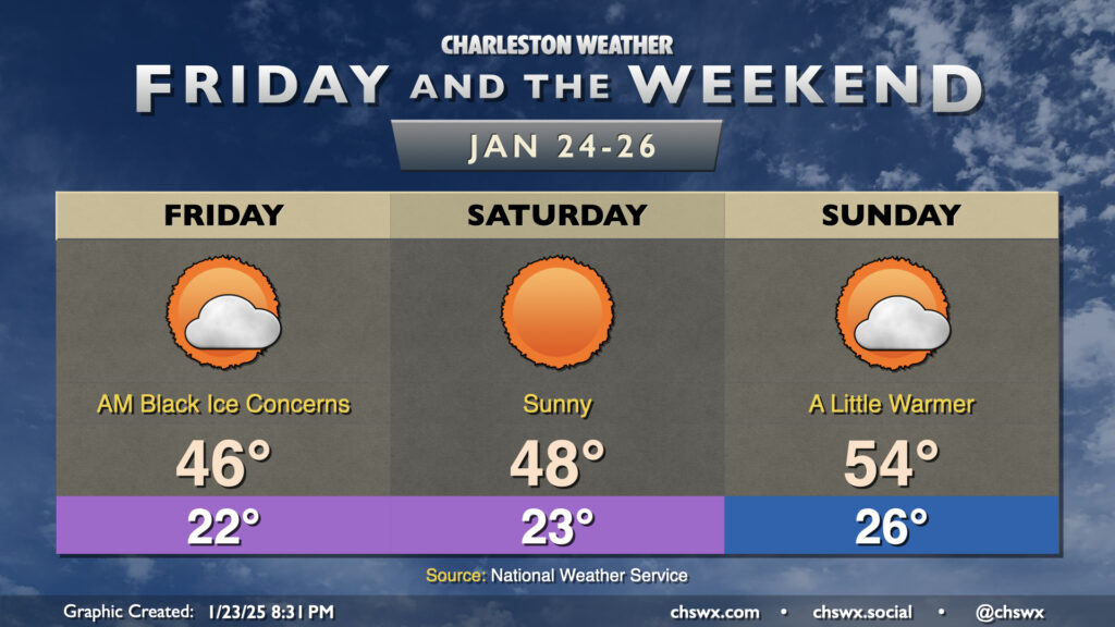
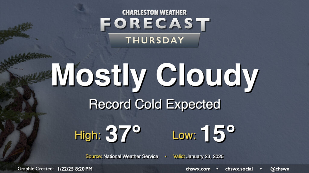
Snowpack is heading into its third day here in the Lowcountry, with many roads still a little on the sketchy side and black ice being a concern once again overnight Thursday into Friday morning. It’s kept us on the chilly side, too: the high today hit 40° at the airport, while the high of 38° at downtown Charleston was a record cold high temperature for January 23. We’re already back into the 20s as of this writing (8:45 PM-ish) with temperatures expected to fall into the low 20s given much less cloud cover than last night and the continued snowpack. Winds a little more out of the west should kick in on Friday, though, and we should see highs peak in the mid-40s along with more sunshine than we saw Thursday. Still, melting during the day Friday should once again contribute to a black ice threat overnight into Saturday morning, so keep that in mind if you head out.
With plenty of snowpack still on the ground, expect a very, very cold night that should set daily records on Thursday morning as lows could fall to as low as 15°. Mix in the persistent northerly wind and wind chills may fall into the single digits. If you’re headed outside tomorrow morning, be bundling up in lots of layers and be very careful for re-frozen ice on steps, sidewalks, and roads.
Additional cloud cover on Thursday isn’t gonna do us a lot of good in the melting department; highs should once again only peak in the upper 30s with mostly cloudy skies generally expected. Wind will remain a bit of a factor, and it’ll feel like the 20s for much of the daytime period.
Getting into Thursday night, I’d expect another round of refreezing and black ice concerns. If you don’t have to travel, it’s probably best to stay hunkered in one more day.
Precipitation has ended across the Lowcountry after an eventful night of winter weather. Snow totals are coming in and a more complete analysis will be doable later today. For now, though, it’s quite cold, and will stay that way for much of the day with so much sleet/snow cover. Cloud cover will clear out, which may be the only thing that gets us back above freezing this afternoon for a brief period. Anything that melts will likely re-freeze, though, promoting a black ice risk across the area especially on bridges and overpasses. (We have a few days of this ahead, too.) If you don’t have to travel, don’t — quite a few roads, including the Ravenel Bridge, Ashley River bridges, and the Northbridge are closed to traffic. Monitor local media for updates on roads throughout the day — and try to have a little fun, too!
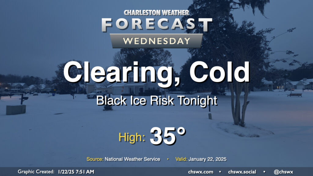
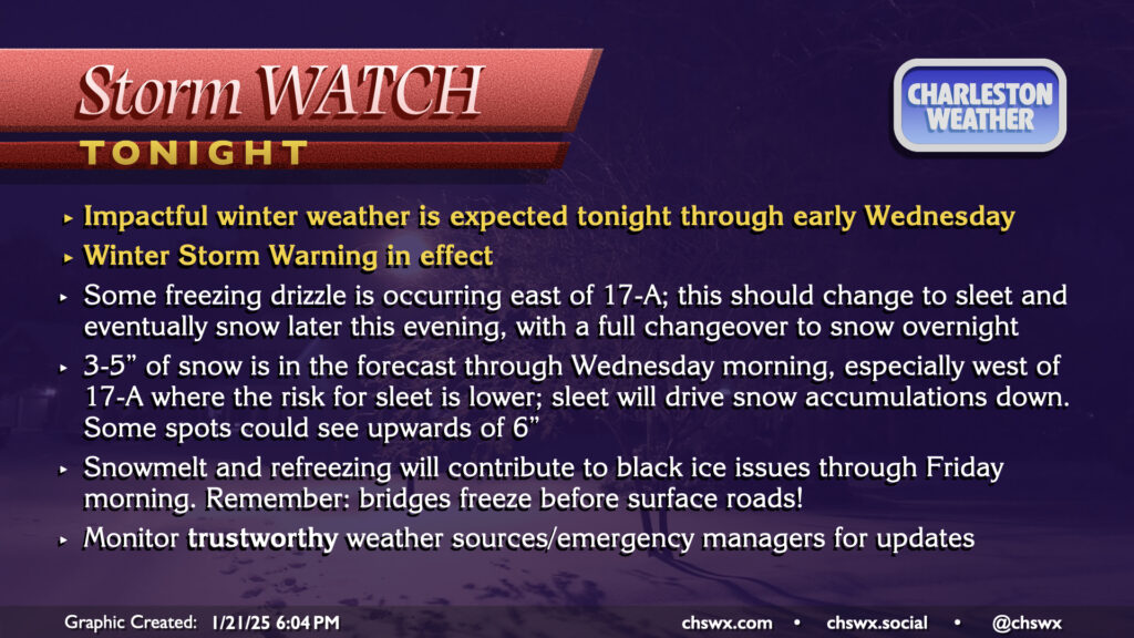
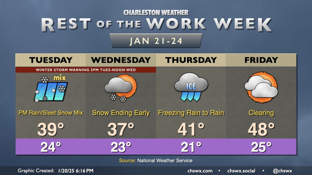
A Winter Storm Warning continues through noon Wednesday as winter weather is beginning to affect the area this evening. So far, we’ve seen some freezing drizzle primarily in the US-17 coastal corridor and points east, with trace accretion reported in places like James Island, Mt. Pleasant, and even at my home in West Ashley. Some bursts of sleet have been reported to be mixing in at times, particularly around Johns Island. Ice pellets have also been reported at the airport, and so we officially have a trace of snow so far today in North Charleston (sleet and snow are functionally considered the same accumulation in the historical climate record).
A special evening weather balloon release continued to indicate a pocket of warmer air aloft that is contributing to primarily freezing rain and sleet so far. The atmospheric column should continue to cool, though, and a changeover to all snow is still expected overnight into early Wednesday morning. By the time all is said and done, many spots should have between 3-5″ of snow. Areas closer to the coast may see accumulations impacted if more sleet falls, while others who stay in the snow longer could see upwards of 6″. This is a pretty stark upward revision from previous forecasts, but thus far all we’ve seen this storm do to our west is overperform. We’ll see how things shake out. Regardless of how much falls, we can still expect some tough road conditions tonight into Wednesday morning even after snow ends. The best course of action is to stay put tonight if at all possible, leaving roads open for essential and emergency workers.
The weather story will continue to be the coldest air of the season and an attendant threat of winter weather, especially Tuesday evening through Wednesday morning. Regardless of what ends up falling at your location, it’ll be quite cold, and you’ll need to put your cold weather plans for your home in place each day through the weekend.
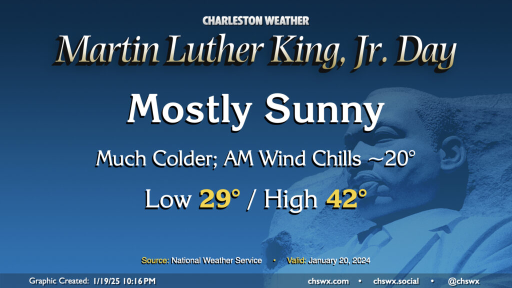
Arctic air will be spilling into the area for Martin Luther King, Jr. Day, bringing the first of several cold days to the Lowcountry. This one will at least come with some sunshine, but even despite that, highs only peak in the low 40s after an upper 20s start. Factor in the wind chill and it’ll feel closer to 20° in the morning, and like the 30s for the balance of the day. Layers will be necessary on Monday and for the next several days as the cold airmass takes residence.