Jared Smith founded @chswx on Twitter in 2008 as an experiment in disseminating weather data through social media. In the ensuing decade-and-a-half, @chswx has provided live coverage of tropical cyclones, tornadoes, severe weather, and even a couple bouts of winter weather to the good people of Charleston, SC.
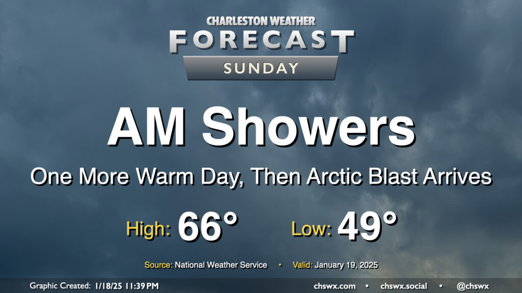
Showers will be ending by early Sunday afternoon as a cold front sweeps through the area later in the day, the forerunner to a much colder Arctic airmass that will arrive overnight Sunday into Monday, setting up a period of impactful winter weather starting Tuesday afternoon.
Temperatures on Sunday will be as warm as they will be for the forecastable future, with highs peaking in the mid-60s early in the afternoon after a start near 50° before falling off post-frontal passage later in the afternoon. We’ll get some peeks of sun as we head through the afternoon and early evening before sunset as much cooler and drier air filters into the area behind the front.
We remain on track to have a relatively quiet but cold day of weather on Monday before winter weather in the form of freezing rain and snow starts to affect the area beginning Tuesday afternoon through Wednesday. I’ll have a more in-depth look at this with Sunday evening’s post as we start to get more of the high-resolution data in, but long story short, we’re quite possibly going to see the most impactful winter weather in the area since 2018 this week. Stay tuned!
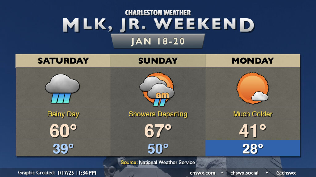
We have a rainy day on tap for Saturday as a complex storm system sweeps across the eastern half of the country. We’ll start the day in the upper 30s to around 40°, but warm to around 60° in the afternoon as warm, humid air moves in ahead of the storm system’s cold front. We’ll stay in the rain for a fair bit of the day after daybreak, though there will be breaks at times as well.
Showers depart early in the day on Sunday, which will be the warmest day in the forecastable future as highs top out in the mid-60s ahead of the cold front. Said front should swing through by evening, and we’ll start to see a sharp change in the airmass after that as Arctic air spills into the region from the northwest. Lows on Martin Luther King, Jr. Day bottom out in the upper 20s, heading to only the low 40s despite plenty of sunshine.
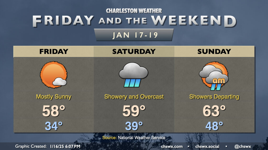
Friday will offer one more quiet day before an extended unsettled period kicks in starting this weekend, culminating in possible winter weather for the middle of next week.
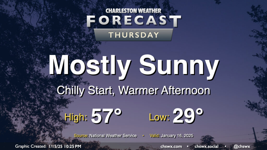
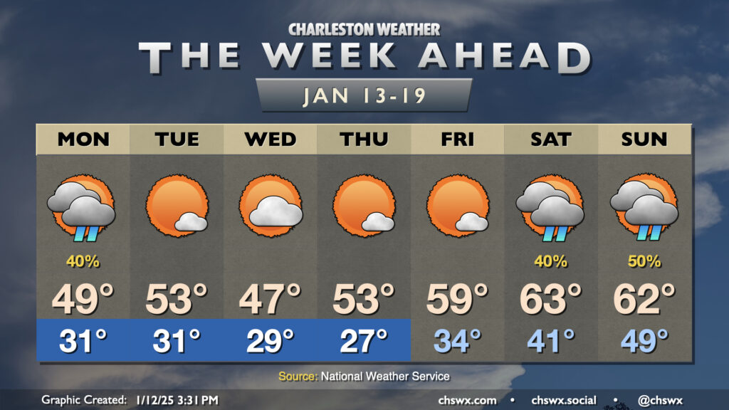
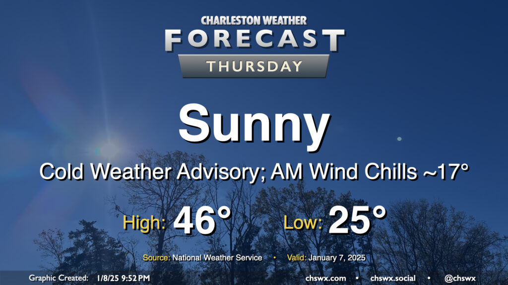
We start Thursday in the upper 20s to low 30s across the metro, but temperatures will ultimately end up a few degrees warmer than Wednesday under mostly sunny skies. This will be the second to last day of generally quiet weather before an unsettled period begins this weekend and lasts into next week, which will turn very cold and perhaps somewhat interesting winter weather-wise, too.
There’s not much to write home about weather-wise for the rest of the work week as generally quiet conditions continue through Friday before turning more unsettled over the weekend.
We start Wednesday right around freezing as a dry front comes through, which will help hold highs down to the low 50s in the afternoon despite plenty of sunshine. Winds turn a little more westerly on Thursday, and after a subfreezing start, we’ll warm to the mid-to-upper 50s in the afternoon under plenty of sunshine. We’ll keep this going for one more day on Friday, with lows right around the freezing mark and highs in the mid-50s with plenty of sun.
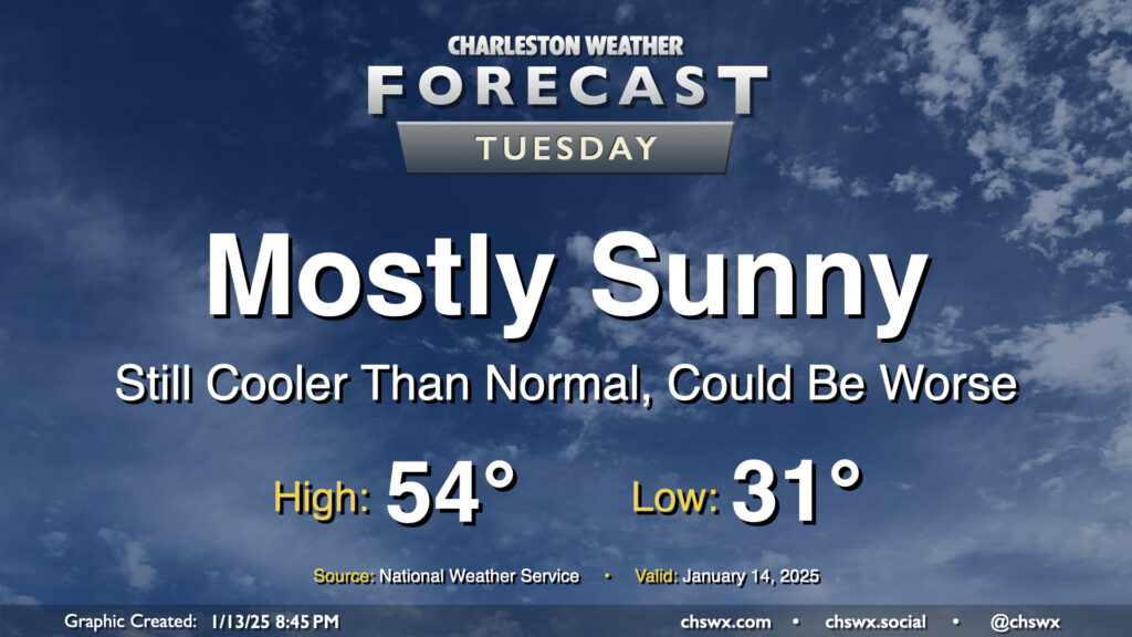
After a dreary Monday the 13th, we’ll see much more sunshine on Tuesday as high pressure rebuilds across the area. Our run of cooler-than-normal temperatures will continue, but it won’t be quite as bad; lows bottom out in the low 30s, just under freezing, and warm to the mid-50s in the afternoon. You’ll still probably need a jacket, but the bitterness of the cold will come down a notch.
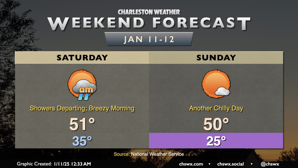
After a day in which we received a trace of snow at the airport for the first time since the January 2018 winter storm, we will dry out on Saturday with low pressure moving away from the area. We start the day with showers tapering off in the early morning; these should be gone by mid-morning, though. Lows will bottom out in the 30s overnight but we’ll be warming up as the night goes on, and we should wake up to temperatures in the 40s Saturday morning. As low pressure departs, so does the cloud cover, and we should end up with a good bit of sunshine before it’s all said and done. Expect highs to reach around 50-51° or so — you’ll definitely still want the jackets.
Sunday starts out in frigid fashion once again with lows in the mid-20s expected. Highs will only reach about 50° despite plenty of sunshine as northerly winds continue to keep the airmass a little on the chilly side. The good news is that we should be largely dried out before Sunday morning’s freeze, so I’m currently not anticipating any traffic concerns. Stay warm and enjoy the weekend!
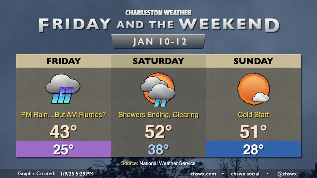
Low pressure organizing in the Gulf of Mexico, just off the southern Texas coast, will move east and northeast heading into Friday, bringing snow and ice to the I-85 corridor and an otherwise raw, gross day of cold rain here to the Lowcountry. We start the day in the mid-20s, and recent guidance signals that there is a slight chance of a few snowflakes through about 10am as a band of precipitation moves north across the area, with the best chance of catching a few conversational flurries further inland around I-95, but they won’t last as temperatures at the surface and aloft warm up. No traffic impacts are expected (unless someone gets distracted by a snowflake, anyway). There should be a little bit of a dry slot in the early afternoon before more steady rain moves in from the west along with the low; this will keep us in the rain for much of the mid-to-late afternoon into the overnight. Highs on Friday will crack the low 40s but won’t warm much more, so again, be ready to bundle up and stay that way if you’re headed out. (Honestly, a great night to stay in with soup and a good movie.)
Thursday will be the coldest day of the week as a little reinforcing cool air moves into the area from the north. We start the day in the mid-20s, but the wind will factor in a bit more than the previous couple mornings, driving wind chills down into the teens across even the Charleston metro area. Thus, a Cold Weather Advisory will be in effect until 9am. Despite unfettered sunshine, highs will struggle to the mid-40s in the afternoon, and with the persistent north to northwest winds around 5-10 MPH, it’ll still feel like the upper 30s throughout the day. Layer up accordingly — you’ll be glad you did.