Weekend forecast: Unseasonably warm; strong storms possible Sunday
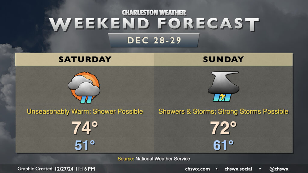
The final weekend of 2024 will be unseasonably warm as we get into the warm sector of an approaching storm system that could bring some rough conditions on Sunday.
Read more »The final weekend of 2024 will be unseasonably warm as we get into the warm sector of an approaching storm system that could bring some rough conditions on Sunday.
Read more »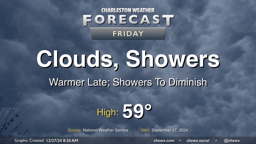
A coastal trough continues to affect the area today, with showers overrunning the top of a cold high pressure wedge that has kept temperatures pretty constantly in the mid-40s for the past couple days now. We should see that trough lift inland later today, though, as high pressure anchored to the northeast weakens and steps aside. This will help break the wedge and allow a little warmer air to move in, especially later, though we will stay somewhat cool with highs in the upper 50s. The risk for showers should also diminish with time today, though we can expect off and on rain for much of it.
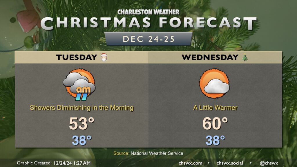
We get Christmas Eve off to a chilly and wet start on Tuesday, but showers will diminish throughout the day as low pressure pulls away from the area. Temperatures bottom out in the upper 30s to around 40°, with wind chills making it feel even cooler. As the day goes on, temperatures will head into the low to mid-50s in the afternoon with some breaks in the clouds developing.
Christmas morning will start out seasonably cool, with lows once again topping out in the upper 30s to around 40°. It’ll be a bit warmer of a day with more sunshine expected; highs should peak around 60° in the afternoon. Northeasterly winds will be a touch on the breezy side, but otherwise, no concerns for Christmas Day.
I hope you have a happy and safe holiday!
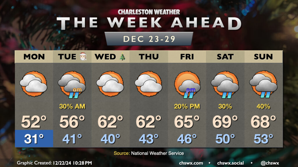
We start the holiday week off on a chilly note. Expect subfreezing temperatures inland of the coast Monday morning, with wind chills in the low 20s expected. We could even see those wind chills drop below 20° further inland, prompting a Cold Weather Advisory for inland Berkeley and Dorchester counties from 4-9am. Cloud cover will build across the area throughout the day Monday, with even a stray shower possible at the coast. Highs will remain well below normal, with low 50s expected at best.
Read more »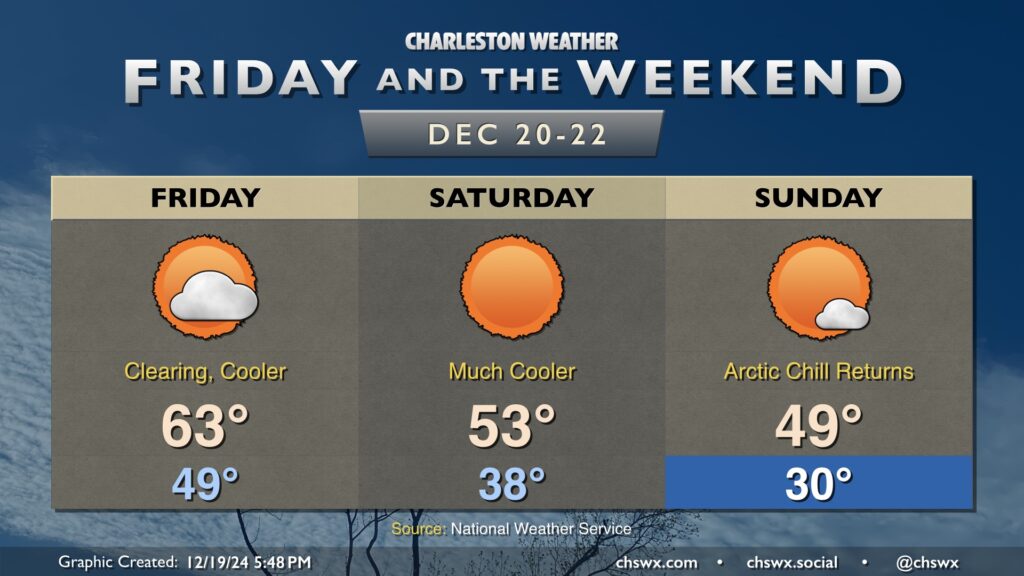
Temperatures will tumble once again as we head into the weekend as a couple shots of cooler and drier air work their way in. Friday will feature decreasing cloud cover throughout the day as the first round of drier air continues to filter in; expect lows in the upper 40s to around 50° to warm to the mid-60s in the afternoon.
A second, more potent, shot of Arctic air works into the area overnight Friday. We’ll feel it Saturday morning as lows head down into the upper 30s. Ongoing cool advection will keep highs in the low to mid-50s despite plenty of sunshine.
Sunday morning dips below freezing for the first time in a few days, with lows in the upper 20s to around 30° expected away from the coast. Highs will once again struggle and may not make it out of the 40s with more sunshine expected.
Read more »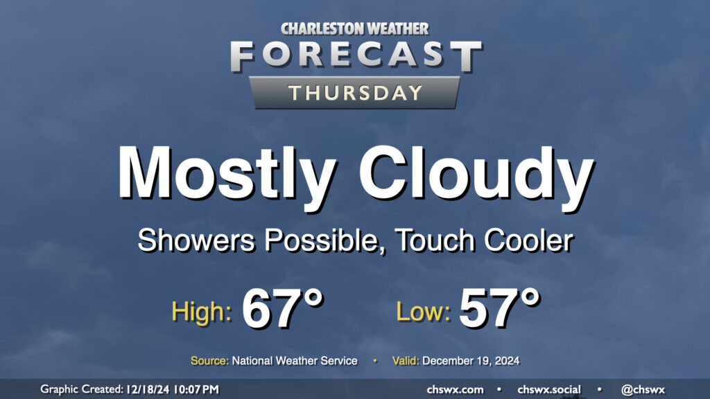
A front will pass through overnight Wednesday into Thursday, but we’ll keep cloud cover around and maybe even a shower or two as a trough of low pressure hangs around for one more day. Temperatures will start in the mid-to-upper 50s once again, but we’ll warm to just the mid-60s with the cloud cover and a somewhat cooler and drier airmass working its way in.
Read more »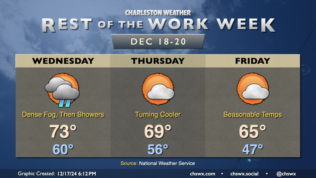
A cold front will swing through on Wednesday to put a bit of a governor on the recent unseasonable warmth, but thereafter, expect a much sharper cooldown into the weekend.
Read more »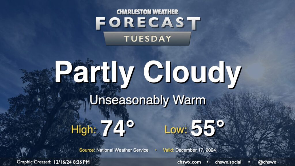
We hit 74° at the airport on Monday, and we’ll likely do the same — if not even running slightly warmer — on Tuesday as high pressure aloft and at the surface remains in control. We’ll likely start the day with another round of fog, and it might be dense in spots as well, so be ready to allow a little extra time to get to where you’re going. (Unfortunately, the fog horns near the coast might be pretty loud, too.) Lows in the mid-50s — about 15° above normal for mid-December — will warm quickly into the mid-70s once the fog dissipates in the morning. We’ll stay rain-free for one more day, with partly cloudy skies expected. Should be a nice day to spend a little time outside if you can!
Read more »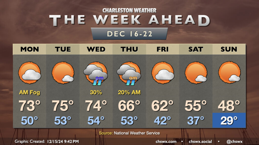
The week ahead will feature another up-and-down cycle of the temperature rollercoaster that has characterized this climatological winter so far. We start the week on the warm side, with temperatures running well above-normal through Wednesday. Monday could start a bit foggy as lows only drop to about 50°. We’ll warm to the low 70s in the afternoon under partly cloudy skies. After what could be another foggy start, expect a little reduction in cloud cover Tuesday afternoon which will lead to what should be the warmest day of the week as highs peak in the mid-70s (and maybe even a bit warmer further inland).
Read more »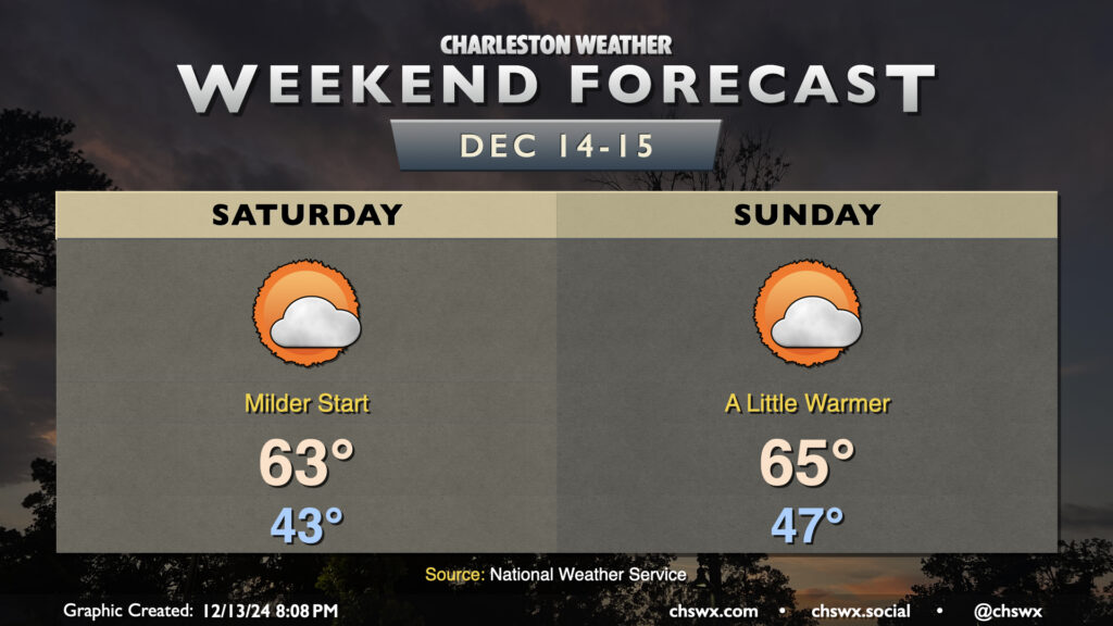
We’ve got a quiet weekend of weather ahead as high pressure remains generally in control. Notably, our starts will be a bit milder: expect Saturday to begin in the low to mid-40s, while Sunday starts in the mid-to-upper 40s as onshore winds help to take the edge off the chill a bit. Temperatures each afternoon head toward the mid-60s, and we can expect a mix of sun and clouds each day.
The only real issues with the weather this weekend come in the form of winds and tides. Saturday in particular will be a breezy day as high pressure butts up against a trough of low pressure that’ll be developing offshore. Winds stay elevated on Sunday, but won’t be quite as blustery.
The northeast winds along with the upcoming full moon will help drive water levels into flood stage in Charleston Harbor with the morning high tides. Saturday morning, we can expect a water level between 7.1-7.3′ mean lower low water with the 6:41am high tide, which is solidly within minor flood stage. We could approach moderate flooding with Sunday morning’s high tide, currently forecasted between 7.4-7.6′ MLLW around the 7:32am high tide. Moderate flooding begins at 7.5′, and this is the level when we start to see more widespread road closures downtown. If downtown’s in your plans early the next couple mornings, be ready to reroute around road closures. Otherwise, enjoy a nice weekend!