Jared Smith founded @chswx on Twitter in 2008 as an experiment in disseminating weather data through social media. In the ensuing decade-and-a-half, @chswx has provided live coverage of tropical cyclones, tornadoes, severe weather, and even a couple bouts of winter weather to the good people of Charleston, SC.
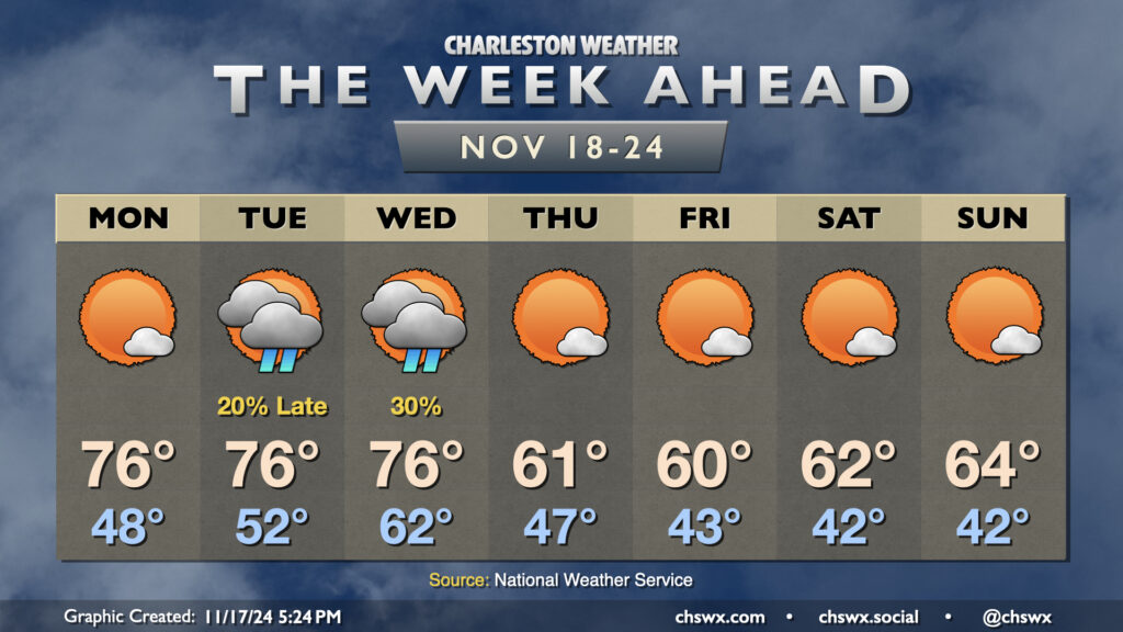
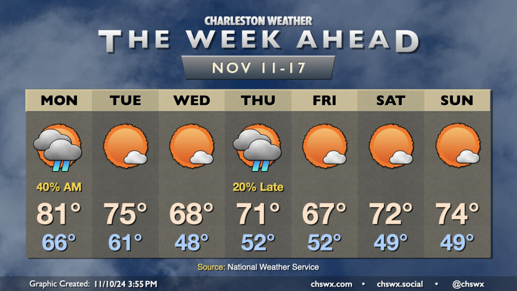
The week ahead gets off to a warm start, but some seasonably cool weather featuring temperatures a few clicks below normal sets in for the second half of the week.
Monday starts with temperatures in the upper 40s. As high pressure begins to shift offshore, we’ll start to see temperatures warm back to the mid-70s in the afternoon under mostly sunny skies. We’ll have one more round of coastal flooding in the morning, but it will not be nearly as severe as what we’ve seen the past few mornings as water levels should only peak around 7.2′ with the 9:31am high tide. Still, expect a few road closures in the more vulnerable trouble spots downtown for a few hours during the commute. From there, winds go more unfavorable and the astronomical impacts from the recent full moon continue to lessen.
The only period of unsettled weather looks to take place later Tuesday through Wednesday as a front comes through (the impetus for our cooldown beginning Thursday). Much of Tuesday should get in rain-free, but will be well on the warmer side of normal with lows in the low 50s yielding to highs in the mid-70s in the afternoon. Shower chances increase around and after sunset, and hang around through midday Wednesday. We’ll see cloud cover diminish as Wednesday goes on, but lagging cooler air will let temperatures back to the mid-70s for one more afternoon after an abnormally mild start in the low 60s.
Cool air begins to kick in overnight Wednesday, and we’ll start Thursday in the upper 40s. Highs on Thursday, though, will struggle above 60° despite considerable sunshine. We’ll repeat this performance on Friday, with an even cooler start in the low 40s. A slow warming trend begins over the weekend, but expect temperatures to remain below normal with highs in the low to mid-60s and lows in the low 40s each day with plenty of sunshine throughout.
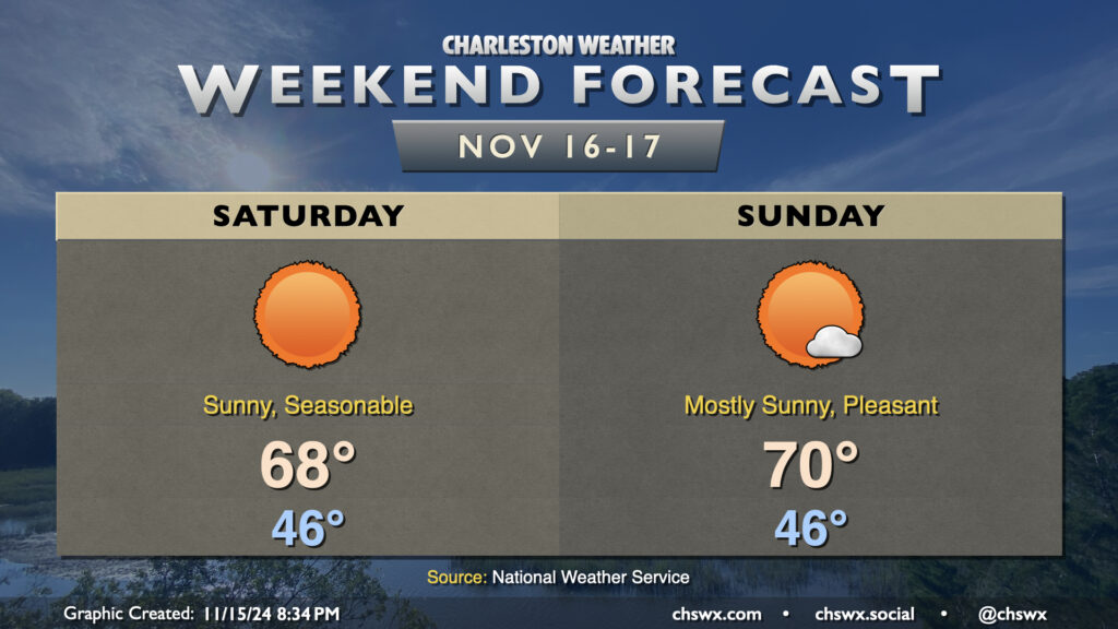
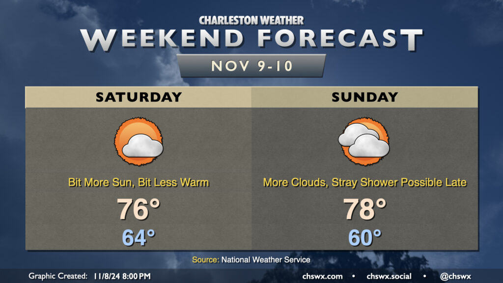
Cool high pressure will be in control this weekend, and we will get a taste of more seasonable conditions for mid-November than we’ve had thus far this month.
First, though, there is the potential for major coastal flooding for the second time in three days with Saturday morning’s high tide, which is predicted around 7:46am. Water levels in Charleston Harbor are projected to peak between 8.1-8.3′ MLLW with this tide, and this will cause numerous road closures throughout downtown Charleston, as well as flooding issues on Isle of Palms, Mt. Pleasant, and perhaps even parts of James Island. Be vigilant and be ready to reroute in case you encounter a flooded road. A Coastal Flood Watch is in effect between 6-10am, and if trends continue, expect this to be upgraded to a Coastal Flood Warning. Also, if the predicted forecast height of 8.2′ comes to pass, it’d be a top-25 tide on record at Charleston Harbor.
Water levels should diminish by mid-morning, and from there, a fairly nice Saturday commences. Expect quite a bit of sunshine, with temperatures warming from the mid-40s in the morning to the upper 60s in the afternoon, just about right on target for normal for this point in the year. Sunday should turn a touch warmer, but a high of 70° is just a teeny bit warmer than normal, so that seasonable feel will continue. Unfortunately, another round of moderate to major coastal flooding is possible with Sunday morning’s high tide, though it should not be as severe as Saturday’s.
From there, a warming trend commences for the first half of the week before a mid-week front. The second half of next week looks much cooler than normal, with highs possibly not making it out of the 50s next Thursday! But let’s enjoy the weekend first.
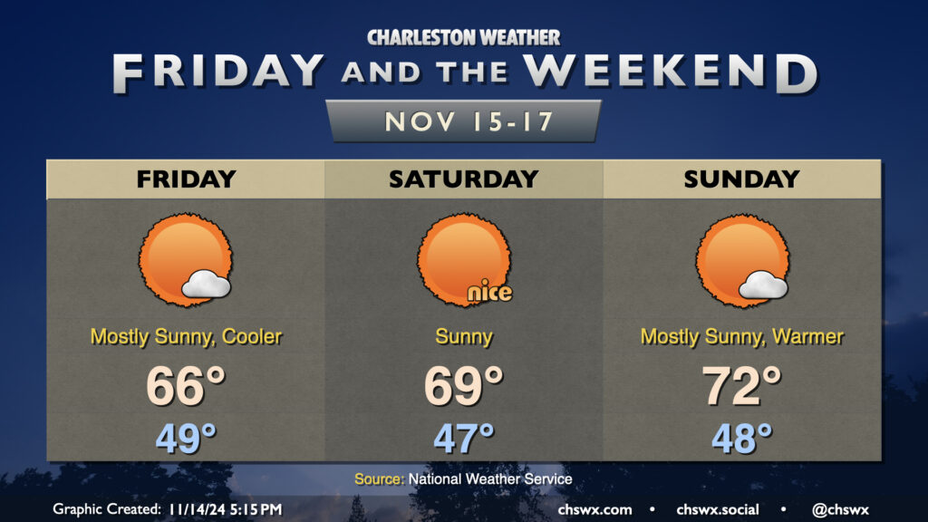
Showers scour out overnight Thursday, and by Friday morning, clouds will be diminishing as cooler and drier air works into the area. We’ll start the day in the upper 40s to around 50°, while the continued influx of cooler air will keep highs pinned to the mid-60s despite increasingly full sunshine. The only fly in the ointment will be the risk for minor to moderate coastal flooding around high tide, which should peak just before 7am. Water levels between 7.3-7.5′ are forecast, which will close some roads, though not as extensively as we saw Thursday morning.
Seasonable and quiet conditions continue for the weekend. Saturday should be a particularly nice day, with lows in the mid-40s yielding to highs in the upper 60s to around 70° in the afternoon, while temperatures turn a little warmer for Sunday as highs get to the low 70s after another upper 40s start. Sunshine will be very prevalent throughout the weekend, and I hope you get a chance to take advantage of weather that feels much more appropriate for mid-November.
Coastal flooding concerns will continue into the weekend, though, with major flooding expected with Saturday morning’s high tide as water levels are expected to peak around 8-8.2′ with the 7:46am high tide. Expect another round of numerous road closures in downtown Charleston on Saturday morning. Moderate to potentially major flooding can’t be ruled out for Sunday morning, either, as water levels once again approach 8′. Keep an ear out for Coastal Flood Watches, Warnings, and Advisories from the National Weather Service as your signal that travel could turn difficult.
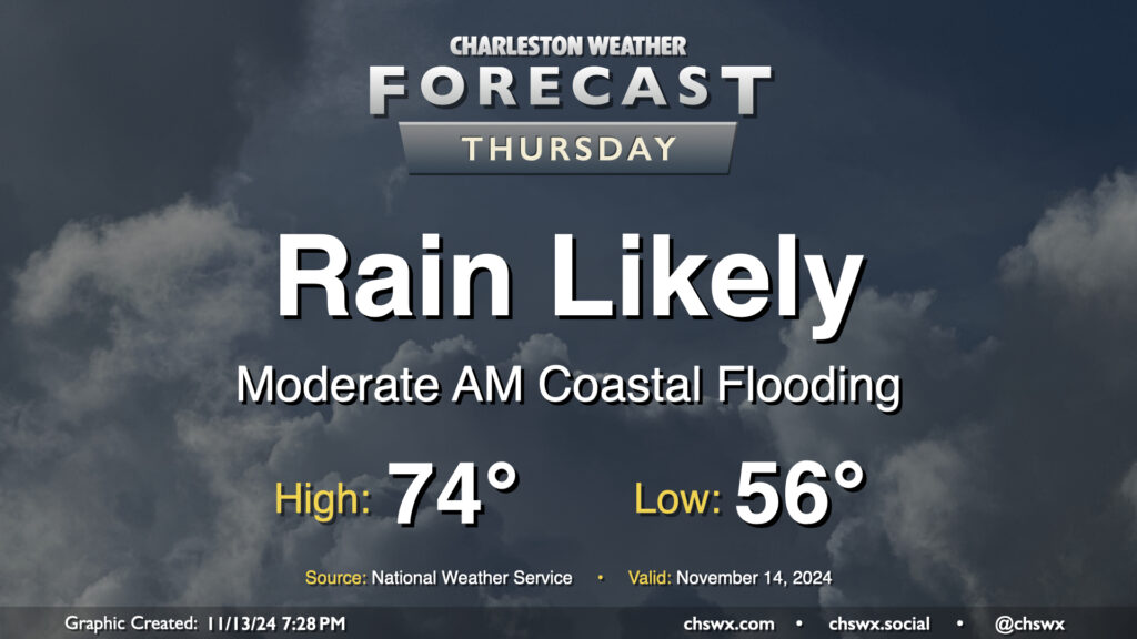
Thursday figures to be a somewhat wet day at times across the Lowcountry, starting with salt water flooding downtown and ending up with showers across much of the area by evening.
First, the salt water flooding: Water levels around 7.9′ MLLW are expected with the 6:07am high tide Thursday. This will produce fairly widespread coastal flooding in downtown Charleston, and should also affect Long Point Road and parking areas around Shem Creek in Mt. Pleasant. Expect numerous road closures early on in the commute, with improving conditions heading into 8-9am. Be alert to detours around the aforementioned road closures, and never cross through floodwaters even if a road is closed — remember, this is all going to be salt water and that is incredibly not good for your car’s undercarriage!
The risk for showers should, thankfully, miss the worst of the salt water flooding. It will begin to kick up around mid-morning to midday, with the best chance of showers on Thursday afternoon into the early evening hours. Rainfall amounts should generally stay under a half-inch in most spots, but locally higher amounts are possible where heavier showers develop. Temperatures start in the mid-50s, topping out in the mid-70s early in the afternoon.
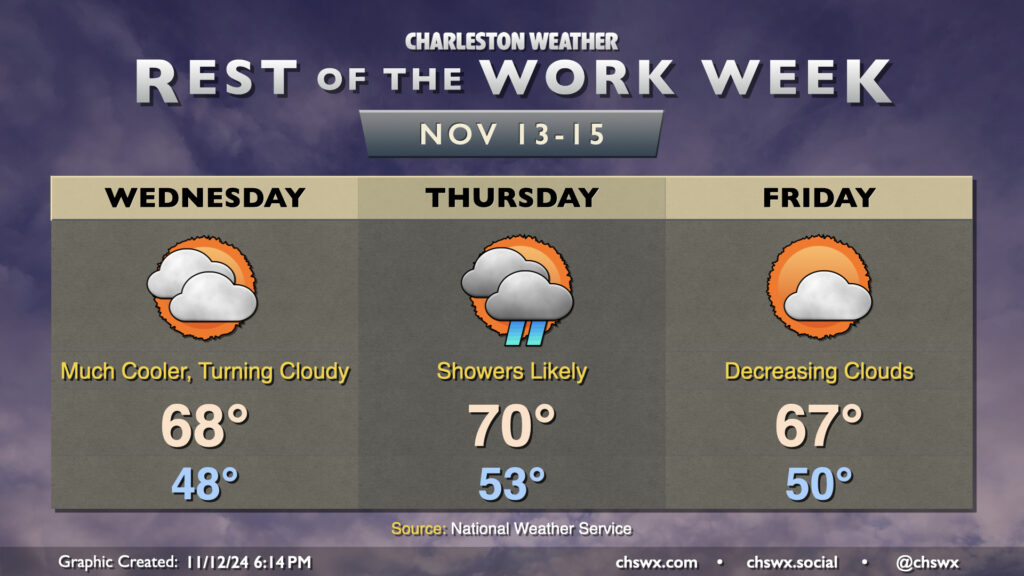
Cooler and drier air will push in overnight as high pressure wedges into the area from the north. This will make for a much cooler day on Wednesday than we’ve had in quite some time, with lows in the upper 40s in many spots away from the coast expected in the morning. High temperatures should only peak in the upper 60s as cooler air moves in. Increasing cloud cover as the day will also assist in keeping temperatures a little lower, too.
High pressure will break down Thursday as a cold front approaches, driving up the risk for showers particularly from midday into early evening. We’ll start the day in the low 50s, warming to around 70° in the afternoon. Rain should generally be on the light side, though some pockets of heavier rain can’t be totally ruled out, either.
The front clears the area for Friday, and cloud cover scours out during the day as a result. Temperatures, though, will once again struggle to the mid-to-upper 60s as cool air behind the front continues to push in. This sets the stage for a seasonably nice weekend, though, with lots of sunshine expected. Expect highs in the upper 60s Saturday, with low 70s returning for Sunday, right around where we should be at the midpoint of November.
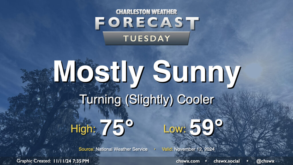
A front swinging through tonight will help start a cooldown across the area that will bring temperatures more in line with where they should be for this point in the year. Lows on Tuesday start in the upper 50s to around 60°, with highs only heading to about the mid-70s despite mostly sunny skies. Drier air will be moving in throughout the day, especially as winds start to go around to the northeast, and it should overall feel pretty nice especially given the recent swampiness that’s characterized November thus far.
A couple fronts this week will finally restore some order to temperatures that have been well above normal to start November. But first, we’ll get one more day in the 80s on Veterans Day with scattered showers to start the day, which will gradually taper by evening as a cold front moves through the area. This front helps knock temperatures back down to the low 60s Tuesday morning, warming to about the mid-70s in the afternoon under mostly sunny skies.
High pressure to the north will then shift a little eastward, allowing for a wedge pattern with northeasterly winds to start to take shape. This will drive temperatures down to — if not slightly below — normal for Wednesday. We’ll start the day sharply cooler — think upper 40s to around 50° — before warming to the upper 60s, once again under mostly sunny skies.
Another front swings through on Thursday. We’ll turn a little warmer ahead of it, and there may be a few showers associated with it. We start Thursday in the low 50s, warming to the low 70s in the afternoon.
Cooler and drier air behind the front moves in for Friday, and we see highs once again running a touch below normal (upper 60s). The airmass moderates a bit heading into the weekend, which looks quite seasonable and nice with lows in the upper 40s yielding to highs in the low 70s each afternoon under mostly sunny skies.
A cold front will sag southward over the area overnight, taking the edge off some of this very unseasonable warmth (which included tying the record high of 85° at the airport today). We’ll still stay warmer than normal this weekend, though, as a more substantial airmass change remains largely out of reach for now.
Saturday starts in the mid-60s as high pressure pushes south into the area. Northeasterly winds will kick up a touch, and this will help keep temperatures from getting too far beyond the mid-70s in the afternoon despite a good bit of sunshine. It’ll be noticeably drier, too: the absurd-for-November 70s dewpoints get shunted southward in favor of drier air characterized by dewpoints in the upper 50s.
The reprieve is somewhat short-lived, though, as the parent high heads offshore, allowing a coastal trough to sharpen and move ashore Sunday. We start Sunday around 60°, but will warm back into the upper 70s in the afternoon with increasing cloud cover along with dewpoints heading back into the mid-60s. A shower or two will be possible as we head into Sunday evening, and that risk will hang around through Tuesday.
Looking ahead, we see next week continuing to generally feature above-normal temperatures for the first half, but a front should swing through late week that will knock temperatures back closer to November normals in time for the weekend.
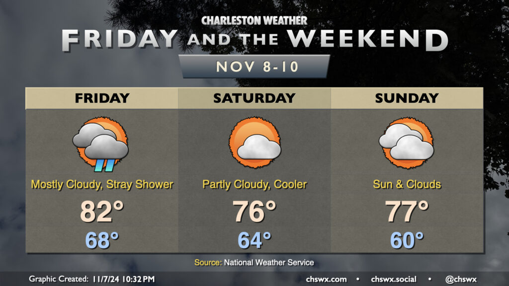
A brief respite from the really unseasonable weather arrives this weekend behind a front, but first we deal with Friday and the potential for a shower or two along with one more day of very warm temperatures. Expect lows in the upper 60s to yield to the low 80s in the afternoon with a mix of sun and clouds around the shower activity.
A front gets through later Friday, though, and this begins to temper things a little bit — though by no means anywhere near where we should be for this point in November. Expect a fairly nice day on Saturday, though, with lows in the mid-60s warming to the mid-70s in the afternoon under partly cloudy skies. A few more clouds arrive on the scene for Sunday, but we should stay rain-free again, with lows around 60° warming to the upper 70s in the afternoon.
We’ll briefly return to the 80s early next week before a front moves by on Tuesday. This front will help take the edge off some of the warmer temperatures, getting us much closer to mid-November normals, but still on the warm side of normal, with highs in the low to mid-70s and lows in the mid-50s expected starting around mid-week.
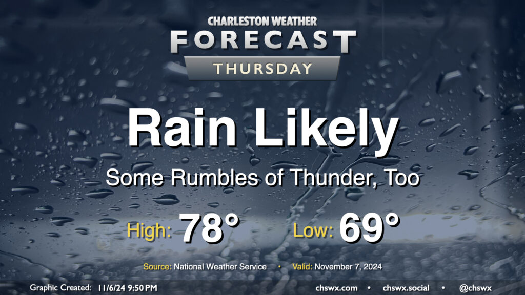
Rain continues on Thursday as northward-moving moisture from Hurricane Rafael interacts with a front. As far as average temperature goes, it’s going to be a particularly warm November day: expect to start the day in the upper 60s to around 70°, with highs topping out around 78° (largely governed by the expected rain). If it verifies, the low of 69° would be a new record warm low temperature for November 7, breaking the record of 68° set in 2018.
Rainfall totals should continue to climb across the area, with another 1-2″ possible across much of the metro overnight into Thursday evening. Expect the best chances for rain during the morning, with some scattering of the activity as we get into the afternoon and evening hours. Flooding doesn’t look to be a major concern here, but if training of rain does occur, some localized issues can’t be ruled out.