Jared Smith founded @chswx on Twitter in 2008 as an experiment in disseminating weather data through social media. In the ensuing decade-and-a-half, @chswx has provided live coverage of tropical cyclones, tornadoes, severe weather, and even a couple bouts of winter weather to the good people of Charleston, SC.
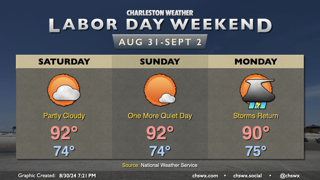
It’s a Meat Loaf-like Labor Day weekend this year: Two out of three ain’t bad. We’ll continue this stretch of warm but mostly quiet weather (aside from a stray shower on the seabreeze) for Saturday and Sunday. Expect to start each day in the mid-70s, warming to the low 90s in the afternoon. Heat indices will generally run in the upper 90s — certainly still hot, but it could (and has!) been much worse.
Attention then turns to a front that will move into the area on Monday. We’ll see the risk for showers and thunderstorms increase throughout the day as the front sags south into the region. Temperatures will peak around 90° one more time before the front ushers in cooler air and continued unsettled weather as we get into the working portion of next week. Severe weather doesn’t look to be a major concern, but we could see brief periods of heavy rain and lightning from any thunderstorm that fires. Remember: when thunder roars, go indoors!
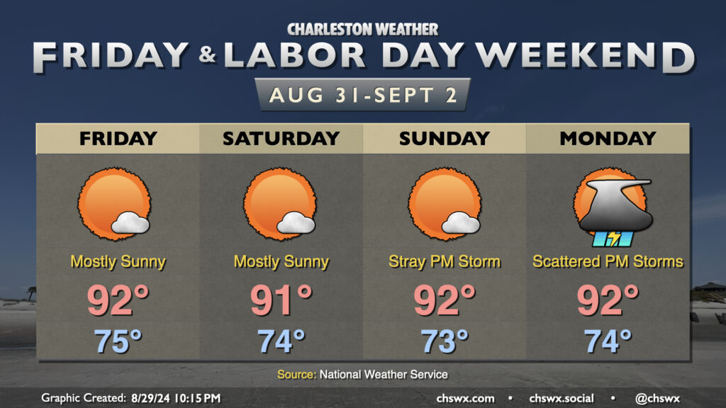
The good news is that much of the upcoming Labor Day weekend is looking pretty good: expect highs generally to run in the low 90s each afternoon, with heat indices in the upper 90s expected after taking into account dewpoints in the low to mid-70s. A stray shower or storm can’t be completely ruled out, especially as you head inland, but otherwise we should stay mostly quiet across the area.
A pattern change is in the offing, though, that will help drive a front toward the area for Monday. We’ll start Labor Day in the mid-70s once again, warming to the low 90s in the afternoon. As the front pushes southward, the risk for showers and thunderstorms will increase, with a decent shot at some storms arriving by Monday evening. This will kick off a stretch of unsettled — but cooler — weather as the front stalls to our south and high pressure wedges southward across the area. A nearby coastal trough should keep rain chances in place for much of next week, though we have a few more summery days to enjoy before then!
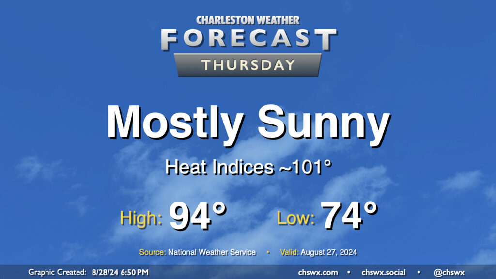
Our stretch of high-pressure-dominated weather continues on Thursday as warm temperatures and mostly sunny skies continue. We start the day in the mid-70s, warming to the mid-90s in the afternoon. Dewpoints in the low 70s will ultimately yield heat indices around 100-101°. A few patches of fog will be possible in the morning, but otherwise, another generally quiet weather day is expected.
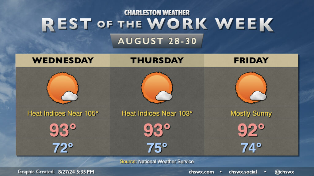
Warm and muggy conditions continue for the rest of the work week as high pressure ridges aloft and at the surface. This should help keep showers to a dull roar, though I suppose with the airmass we can’t ever totally rule out a rogue popup shower (like we saw today).
We may start Wednesday with some fog once again, but that should mix out by 9-10am to yield a mostly sunny day with highs in the low to mid-90s. Dewpoints in the low to mid-70s will combine with those air temperatures to make it feel closer to 105° in the height of the afternoon, so be sure you’re taking frequent breaks and getting plenty of water if you’re outside during that time.
We’ll keep this going Thursday into Friday, with lows in the mid-70s each morning yielding to highs in the low 90s each afternoon with just a few clouds from time to time. The stacked high pressure will give any enterprising updraft trying to become a shower a very, very hard time, and rain-free conditions are expected as a result.
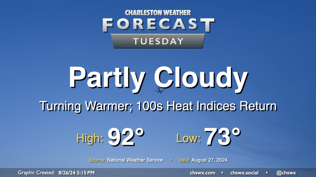
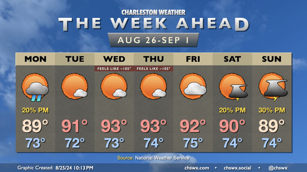
High pressure will bring a pause in the rain and a further uptick in temperatures starting Tuesday. We start the day in the low to mid-70s (warmer near the coast), warming to the low 90s in the afternoon under partly cloudy to mostly sunny skies. With 70s dewpoints continuing their comeback, expect heat indices in the low 100s to return to the area as well — a fair bit warmer than we’ve been used to recently, but staying below the heat advisory thresholds we got to know very well during July.
The final week of August will end on a warm and more humid note than the past 7-10 days have offered across the area. Storms will take a pause, though, as high pressure aloft puts a lid on widespread cloud cover, much less thunderstorm development, for much of the week.
The stationary front that’s kept shower chances in the neighborhood over the weekend still lingers nearby, and a shower or two will be possible (though unlikely) on Monday. Dewpoints will continue their steady climb, peaking in the mid-70s, which will make the upper 80s feel more like the mid-90s.
High pressure aloft will become more entrenched across the area starting Tuesday, setting us up for a rain-free stretch through Friday that will feature warmer-than-normal temperatures for late August. We should see highs peak in the low-to-mid-90s each afternoon, and with dewpoints peaking in the mid-70s, heat indices should head back into the 100s especially Wednesday-Friday. We’ll fall short of the Heat Advisory threshold of 108°, but it’ll still be plenty warm with just a few clouds to hide the sun from time to time. The high pressure pattern will keep winds generally light, too, so there won’t be much of a breeze, either.
As we head into Labor Day weekend, the high pressure ridge aloft gets shunted south and west as a trough digs in a bit to our north. This will kick up the chance for a few afternoon thunderstorms and take some of the bite out of the heat, but it’ll still be plenty warm as we bid farewell to summer as meteorological fall begins on Sunday.
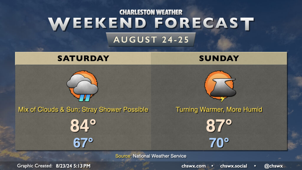
Cool high pressure will hang tough over much of the Carolinas heading into the weekend, though coastal areas could run a little warmer and more humid depending on the position of a stationary front/coastal trough nearby. The trough keeps cloud cover in the forecast for Saturday in particular, and that combined with northeasterly winds will keep temperatures down into the mid-80s in the afternoon after another mid-60s start. A stray shower or thunderstorm will be possible Saturday, particularly closest to the coast, with the nearby trough. A little more humidity creeps into the area for Sunday as winds just off the deck turn more onshore. It remains to be seen just how deep the moisture becomes with some fairly serious differences in model guidance showing up, but ultimately be ready for an isolated storm or two Sunday afternoon. We will see dewpoints return to the low 70s; as high temperatures head to the mid-to-upper 80s, that will yield heat indices in the low 90s. Nothing terribly heinous, though certainly not as comfortable as it has been.
While northeasterly winds continue around the high pressure wedge, the risk for coastal flooding around times of high tide has ended as the tidal departures will stay below flood stage (though they will creep into action stage from time to time). One less thing to worry about, at least. Enjoy the weekend!
The whiff of fall we’ve felt the past day or two starts to retreat a bit as we head into Friday and the weekend. (All good things…)
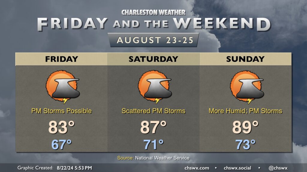
We do get one more really nice start on Friday, though. Expect to start the day in the mid-60s in much of the metro, running closer to 70° near the coast and even cooler further inland. We’ll warm to the low 80s in the afternoon under mostly cloudy skies. Dewpoints will be climbing back into the upper 60s, so while not terribly oppressive, the humidity will be a little more noticeable. It should also support the risk for a few showers and thunderstorms in the afternoon after a couple reasonably quiet days.
The warming trend continues into the weekend. We’re back in the mid-80s on Saturday and the upper 80s on Sunday as dewpoints return to the 70s. Scattered showers and thunderstorms will remain possible each afternoon, but not everyone will see rain, nor will it be the kind of rain to completely ruin the day, either. Just keep an eye out for possible storms and be ready to move outdoor activities inside for a bit.
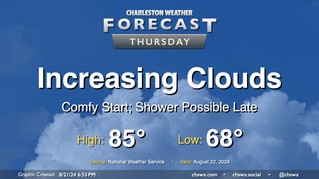
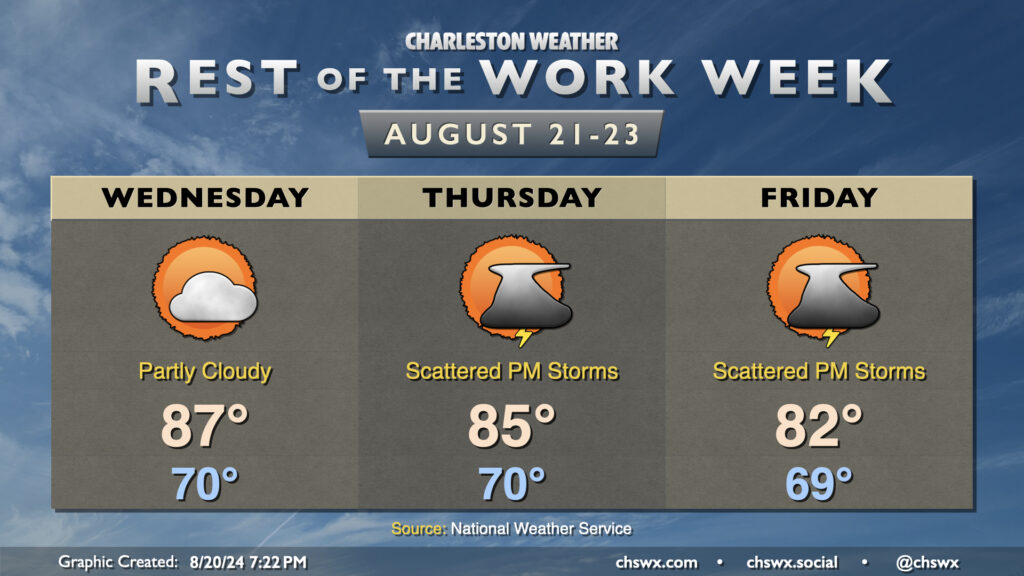
We’ve got a reasonably comfortable day (especially as late August goes) for Thursday as cool high pressure continues to rule the meteorological roost in our neck of the woods. We start the day in the upper 60s in much of the metro, likely dropping even lower further inland and in more rural locations. Temperatures should warm to the mid-80s in the afternoon, but humidity will be quite tolerable with mid-60s dewpoints expected. Clouds will be on the increase as a coastal trough takes shape, and there will be a risk for a shower near the coast, but much of us get the day in rain-free.
The rest of the work week will feature a cooling trend as high pressure wedges into the area from the northeast and troughing aloft persists. Wednesday should feature a lower storm chance than we’ve seen the past couple days as some drier air takes hold across the area. Temperatures start around 70°, warming to the mid-to-upper 80s in the afternoon with dewpoints in the upper 60s expected.
Thursday into Friday will feature even cooler temperatures as the wedge intensifies over the area; expect mid-80s on Thursday and low 80s on Friday. The intensifying high pressure should lead to a tightening pressure gradient which will drive some gusty winds, particularly around the coast. The onshore winds combined with the recent lunar perigee will also promote coastal flooding around times of high tide (both morning and evening) starting Wednesday evening through at least Friday. Right now generally minor flooding is expected, which is enough to close some of the more vulnerable roads in downtown Charleston.
Shower and thunderstorm chances come back into play for Thursday and Friday as well as more moisture starts to work back into the area, with the best chances of rain closer to the coast. Inland locations may even stay rain-free where drier air is expected to hold firm. No severe weather is expected, though a downpour or two can’t be totally ruled out.