Jared Smith founded @chswx on Twitter in 2008 as an experiment in disseminating weather data through social media. In the ensuing decade-and-a-half, @chswx has provided live coverage of tropical cyclones, tornadoes, severe weather, and even a couple bouts of winter weather to the good people of Charleston, SC.
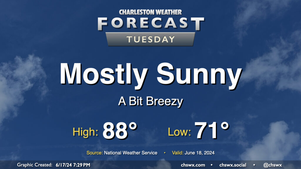
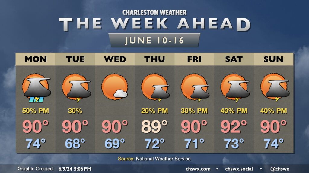
We’ve got one more generally quiet day of weather coming up for Tuesday before turning a little more unsettled heading into the second half of the week. Temperatures will remain around if not a touch below normal as a solid onshore breeze keeps us on the “cool” side. We’ll see a few clouds from time to time, but overall, expect a mostly sunny day. The only downside to the onshore flow will be a moderate risk of rip currents at the beaches, so be alert if you are going to be heading into the surf.
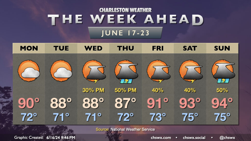
The week ahead will generally feature temperatures around if not even a touch below normal at times through mid-week before warming back up, perhaps into the mid-90s, for the weekend.
We start the week off fairly quietly as a little bit of lower-dewpoint air nudges into the area, generally capping highs in the upper 80s to around 90°. High pressure aloft and at the surface will keep thunderstorm chances very low, so expect to at least get the first couple days of the week in rain-free.
High pressure starts to weaken as we head into Juneteenth, and the standard summertime afternoon thunderstorm chances respond accordingly. Storms could be a little more widespread Thursday as low pressure approaches Florida, enhancing the flow of moisture into our neck of the woods. A warming trend begins Friday as high pressure offshore moves a little further south, turning the resulting flow at the surface more southerly as well and essentially turning the heat pump back on. Low-to-mid-90s temperatures are expected Friday through Sunday, with scattered thunderstorms each afternoon.
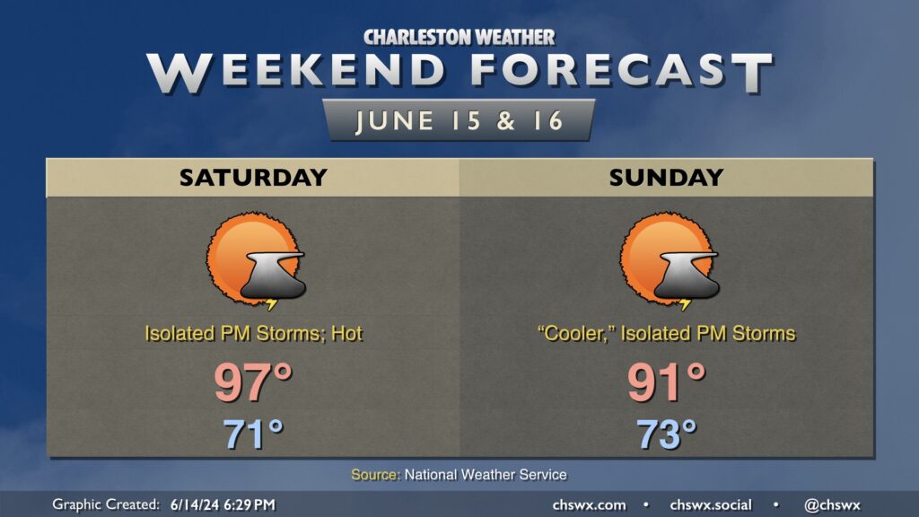
Heat continues to build into Saturday before onshore flow knocks thermometers down a few clicks starting Sunday. After starting the day in the low 70s, temperatures should head to the mid-to-upper 90s in the afternoon especially away from the coast. A few thunderstorms are possible in the afternoon as the seabreeze moves inland, which may offer some relief, but otherwise, be ready for a hot day that’ll feature heat indices over 100° at the height of the afternoon. Take frequent breaks in the shade and with plenty of water if you must be outside.
Winds turn more onshore Sunday, which will make it a little more humid but also “cooler” (technically, 91° is cooler than 97°), though heat indices will peak in the upper 90s so it all comes out in the wash. A few storms will be possible along and ahead of the seabreeze once again in the afternoon, but a rain-free day is quite possible for many of us. Just be ready to bring outdoor activities inside in case a storm threatens your location.
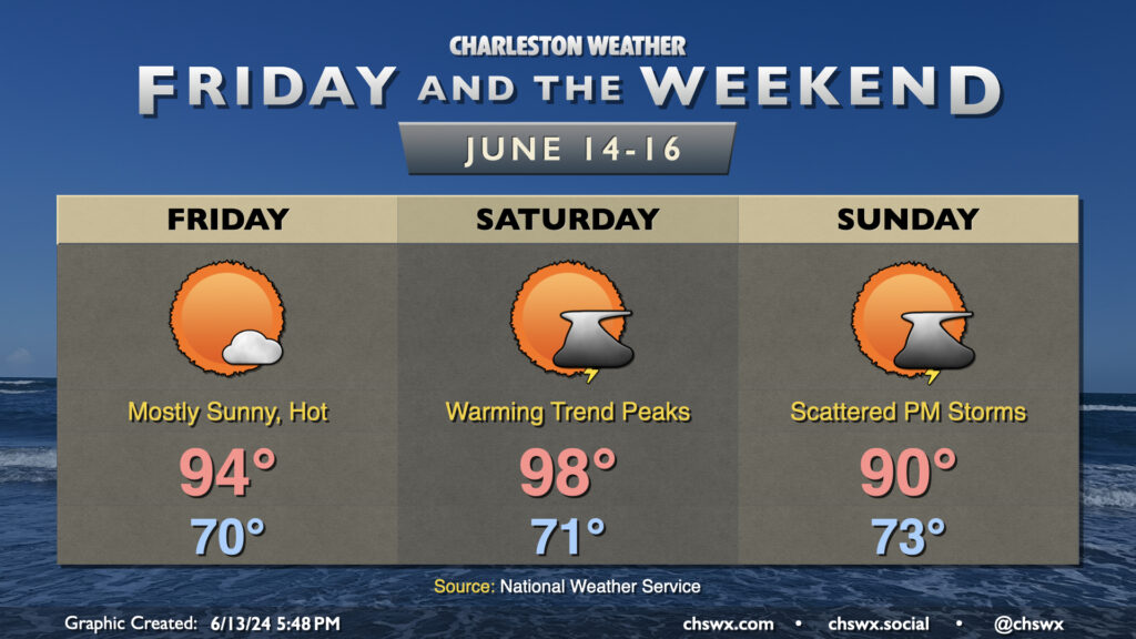
Temperatures climb fairly sharply before dropping off back toward normal as we get into Friday and the weekend. Friday will start around 70°, warming to the mid-90s in the afternoon under mostly sunny skies as ridging builds aloft. We make a run toward the Lachey mark on Saturday as highs top out near 98° away from the coast. Dewpoints in the low 70s will contribute to heat indices approaching 104° or so during the height of the afternoon, so be sure that you’re getting enough hydration and taking breaks if you’re going to spend time outdoors. Temperatures back off a bit for Sunday as the wind turns more onshore, but will still be plenty of warm with highs around 90°.
We’ll stay rain-free Friday, but the standard afternoon chance of scattered showers and thunderstorms re-enters the weather picture on Saturday into Sunday as another front stalls out nearby. Overall, though, we should see more sunshine than not. Try to stay cool!
Thursday could feature a few showers and storms brushing the coast as low pressure tries to organize along a stationary front that’s been lingering offshore for the past few days. It’ll otherwise be a fairly standard warm June day — lows in the low 70s yielding to highs around 90° in the afternoon under a mix of sun and clouds. Dewpoints in the upper 60s will help keep heat indices from getting too far out of hand, thankfully.
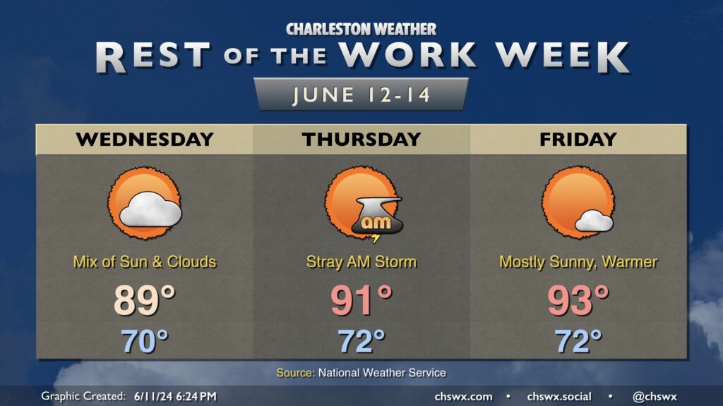
The rest of the work week will generally trend warmer and stay mostly rain-free, especially the further inland you are. Expect generally partly cloudy skies Wednesday, though we’ll see a disturbance swing through later in the day that’ll add some high cloud cover to the mix. Expect highs to top out in the upper 80s to around 90° after a start around 70°.
The aforementioned disturbance in association with the stalled front nearby could kick up some stray showers and thunderstorms on Thursday, especially near the coast. Most locations inland of 17 could have a brief window for a storm or two Thursday morning, but the vast majority of us should get the day in rain-free. Temperatures get a little warmer, with a low 70s start yielding to highs in the low 90s.
The disturbance and associated low is out of here by Friday, yielding a warm and mostly sunny day. Once again, we start in the low 70s, warming to the low to mid-90s in the afternoon. We’ll keep this warming trend going into the weekend, with upper 90s possible on Saturday.
It’s a low bar to clear, but Tuesday will be much quieter than Monday was weather-wise as drier air noses in from the northeast. This should be enough to keep storms, much less significant cloud cover, at bay for a day. We start the day in the upper 60s to around 70°, warming to about 90° in the afternoon under mostly sunny skies. Unfortunately, we’ll need the good weather for some cleanup after severe storms brought large hail and damaging winds to the Summerville area on Monday evening.
After highs topped out in the mid-90s on Sunday, we’ll see temperatures back down a little bit toward normal heading into the upcoming work week as a front crosses through and stalls out nearby, potentially bringing a somewhat unsettled Monday. Showers and thunderstorms could be in the area during the morning hours, but the better chance for rain arrives in the afternoon and evening as more forcing arrives. Temperatures start in the mid-70s, heading to around 90° under a mix of sun and clouds.
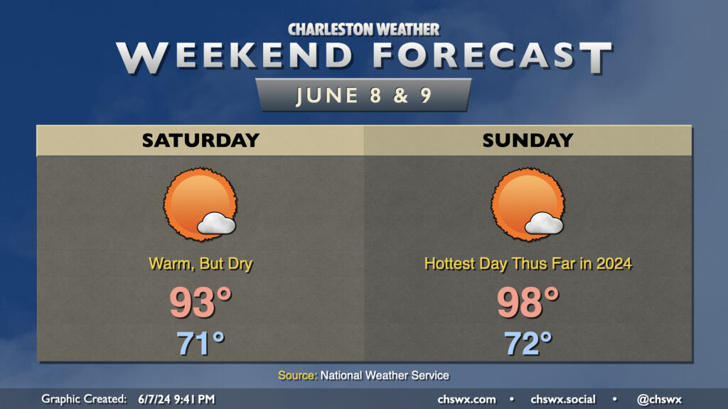
We’ve got quite a warm weekend ahead with plenty of sunshine. Thankfully, humidity will not play a major role as dewpoints mix out to the 50s on Saturday and the low 60s on Sunday. In fact, Saturday could be one of those days where the heat index is actually lower than the air temperature at times as relative humidity values will head down to around 35% during the height of the afternoon.
Sunday may end up as the hottest day thus far in 2024. The forecast high of 98°, if it verifies, would be the warmest day since August 14, 2023, when it was also 98°. Thankfully, we’ll keep dewpoints in the low 60s, which will keep heat indices below 100°. Still, 98° is plenty, plenty hot — if you’ll be outside, make sure you’re taking breaks and staying hydrated. Don’t forget the sunscreen, too, especially if you’re headed to the beach — it’s prime UV season, after all.
Despite the heat, thunderstorm chances will be nil — just too much dry, sinking air for afternoon thunderstorms (much less a robust cumulus field!) to develop. The next rain chances arrive Monday, and we could stay somewhat unsettled heading into next week as a front stalls out nearby.
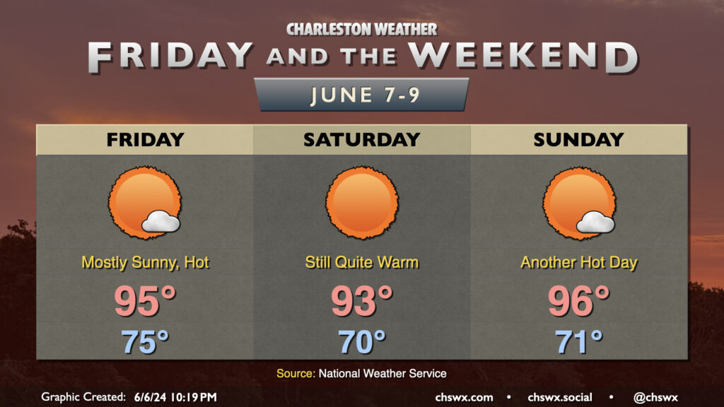
Mother Nature will come out throwing heat this weekend — thankfully coming along with lower dewpoints than we typically see in summertime. A “cold” front swings through during the day Friday, and while the airmass will trend drier, it’ll still be quite warm — highs in the mid-90s are expected. Thankfully, the drier air keeps heat indices within a degree or two of the air temperature. Sunshine will be in abundance, with the dry, sinking air keeping cloud cover at a minimum.
We’ll keep this going into the weekend. Saturday will be the “cooler” of the two days, but still plenty warm with highs reaching the low to mid-90s under mostly sunny skies. Sunday turns a little warmer and a touch more humid, with highs solidly in the mid-90s under mostly sunny skies once again. The next shower or thunderstorm chance arrives Monday afternoon as dewpoints continue to climb heading into next week.