Jared Smith founded @chswx on Twitter in 2008 as an experiment in disseminating weather data through social media. In the ensuing decade-and-a-half, @chswx has provided live coverage of tropical cyclones, tornadoes, severe weather, and even a couple bouts of winter weather to the good people of Charleston, SC.
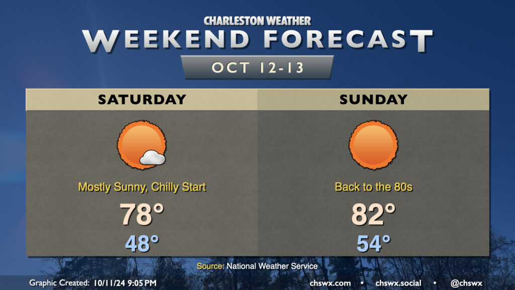
We have an outstanding weekend of weather ahead as high pressure remains in control. After our first low in the 40s Friday morning, Saturday starts back in the upper 40s once more, but winds will start to swing around to the south and that will begin to help moderate the airmass a bit. Expect just a few passing clouds Saturday afternoon, but otherwise, lots of sunshine will be the rule.
Sunday will be a warmer day. We start the day in the mid-50s, warming back into the low 80s in the afternoon under mostly sunny skies. It’ll be a very comfortable low 80s, though, as humidity will be a non-factor with dewpoints in the mid-50s.
I hope you get a chance to enjoy this wonderful weekend of weather!
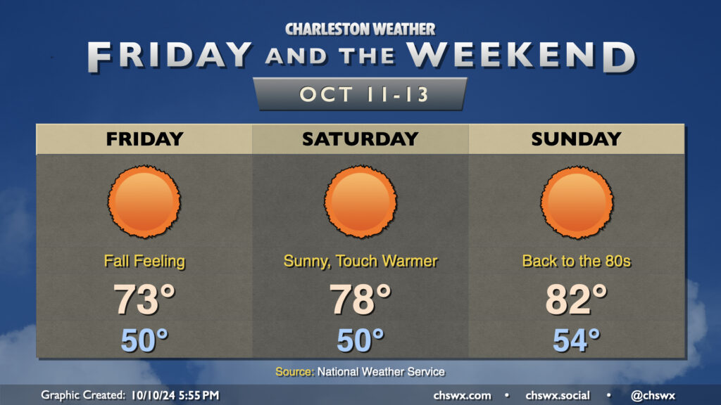
Get ready for the first low 50s of the season starting tomorrow morning! Lows are forecast to bottom out around 50° — and into the upper 40s further inland — for the first time since April 24 on Friday morning. This will yield to highs in the low 70s in the afternoon under predominantly sunny skies. The northeast breeze will still be elevated in the morning, gradually winding down as we get into the evening.
Saturday gets off to a similarly chilly start, though the airmass will begin to moderate as highs climb back into the upper 70s in the afternoon with nearly uninhibited sunshine expected. The warming trend continues Sunday, with a slightly warmer start in the mid-50s warming to highs in the low 80s in the afternoon.
The only weather-related concern of note will be the risk for some minor flooding around the afternoon high tides Friday and again on Saturday as the northeast breeze persists. However, major flooding disruptions do not appear to be in the cards.
Finally, there’s nothing in the tropics we need to be worried about. In fact, it may be a while before we get any more rain. A dry front early next week could usher in even cooler weather, well below normal for mid-October standards. Watching it…
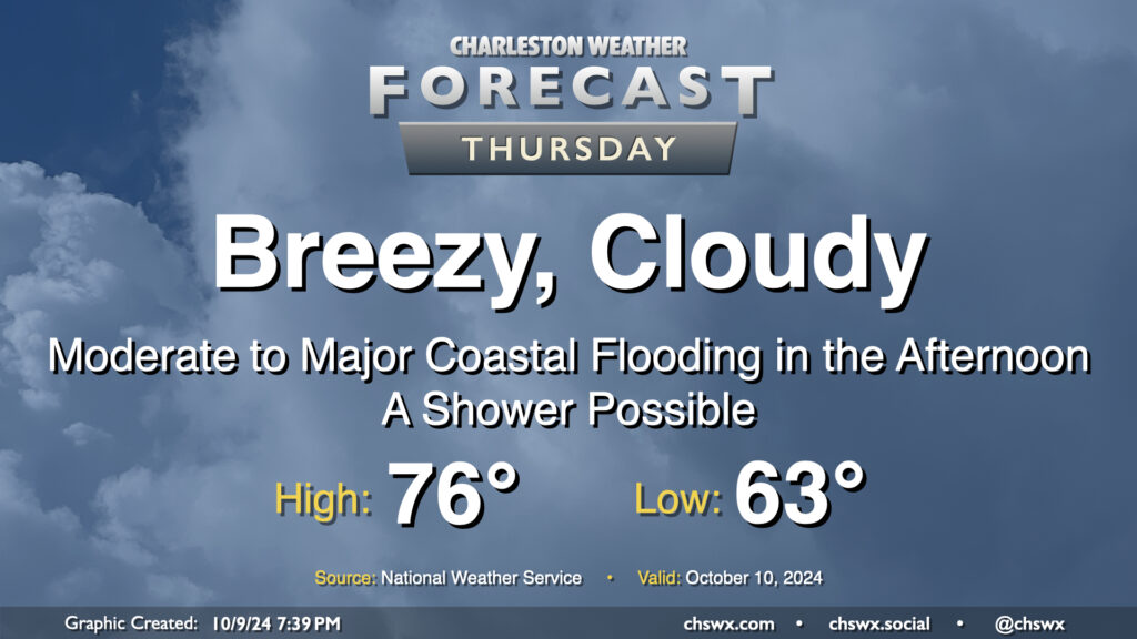
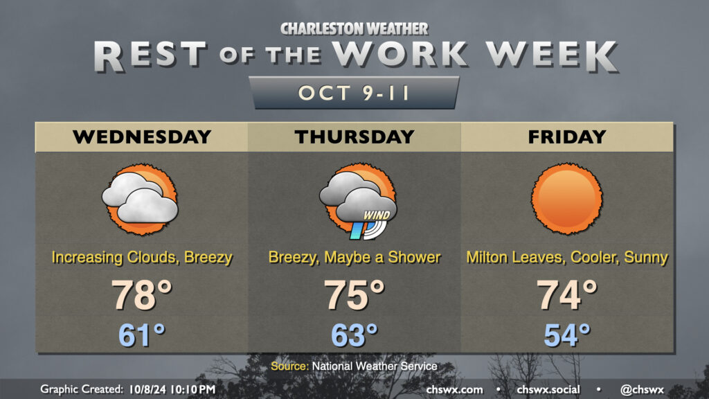
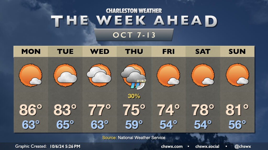
Our brush with Milton arrives on Thursday. The Tropical Storm Watch was dropped as tropical storm conditions are not expected on land (though a Tropical Storm Warning is in effect for the coastal waters). However, that doesn’t change the forecast: It’ll still be a breezy day, with a Wind Advisory in effect for the area from 6 AM to 8 PM as the gradient between high pressure to the north and Milton to the south pinches and drives gusts upwards of 40 MPH across the area. Moderate to major coastal flooding is also expected during the afternoon, with some salt water flooding possibly persisting into early evening depending on how high the tidal departure ends up being. Right now, moderate flooding is forecast as the harbor should peak at 7.8′ MLLW with high tide just before 2 PM. This will close roads in downtown Charleston and parts of Mt. Pleasant, especially around Long Point Road. Be ready to reroute in case you encounter a flooded road.
The rain threat, however, is minimal. We may see a few showers sneak in from time to time, but we will miss out on Milton’s rainfall. In fact, we can expect skies to start to clear as we get further into the afternoon and evening. Temperatures will start in the low-to-mid-60s, warming to the mid-70s in the afternoon.
Clouds will increase on Wednesday as Hurricane Milton draws closer to landfall in Florida. We’ll see a decent northeasterly breeze during the day, but nothing unmanageable, and we’ll stay out of the rain, too. The day starts on a fairly cool note with lows in the low 60s, and we’ll warm to the upper 70s in the afternoon, tempered by the northeasterly winds and the increasing cloud cover. There will be a chance for some minor coastal flooding a couple hours around the 12:41 PM high tide, and a Coastal Flood Advisory is possible.
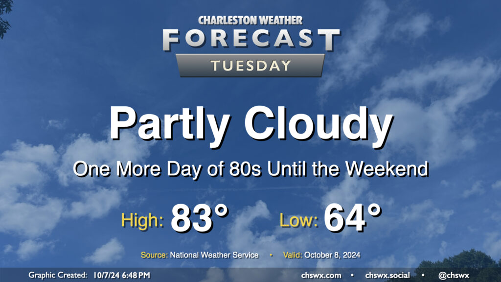
Quiet and warm weather continues Tuesday as we continue to monitor Hurricane Milton in the Gulf of Mexico for possible peripheral impacts on the Lowcountry as we get into Wednesday night and Thursday. Expect a comfortable start in the mid-60s on Tuesday, with temperatures warming to the low-to-mid-80s in the afternoon under partly cloudy skies (though clouds will be increasing as the day goes on). Northeast winds will generally run 10-15 MPH across the metro.
A cold front brings a shot of Fall to the area as we get into the meat of the new week with a possible brief appearance by Hurricane Milton as it departs into the Atlantic and turns extratropical.
Monday will be the warmest day of the week ahead of the aforementioned cold front. We’ll start the day in the low to mid-60s, which is right around where we should be at this point in the year. Temperatures will warm to the mid-80s in the afternoon under mostly sunny skies.
The front gets through Tuesday morning. We’ll start Tuesday in the mid-60s, but will only warm to the low 80s in the afternoon with a bit more in the way of cloud cover as the front stalls out to our south. Cloud cover and northeasterly winds increase Wednesday as Milton draws closer. This will keep highs only in the mid-to-upper 70s in the afternoon.
On the current forecast track, we can expect peripheral effects from Milton starting Wednesday night and peaking on Thursday. Showers will be possible near the coast, but the main concerns will be gusty winds as the gradient pinches between Milton to the south and high pressure to the north, rough surf and rip currents, maybe some beach erosion, and coastal flooding, which may be significant come Thursday. It’s too early to know the extent of those impacts, but it’ll be worth watching for travel troubles downtown around times of high tide.
The good news is that Milton departs quickly, and the weekend looks excellent, with the first solid stretch of lows in the 50s of the season expected through Sunday. Temperatures warm from the mid-70s on Friday to the low 80s on Sunday with plenty of sunshine expected.
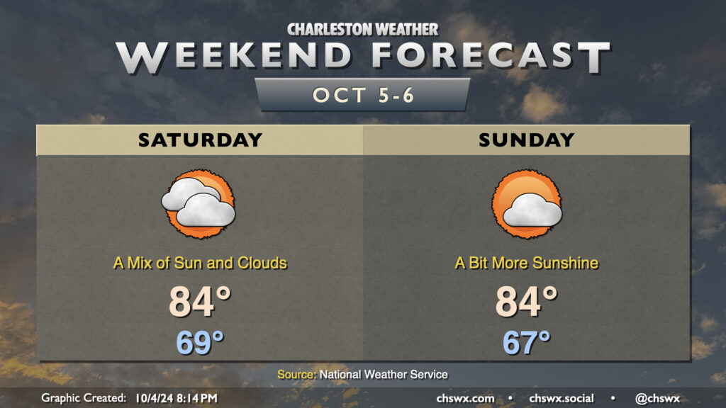
Quiet weather is expected this weekend as high pressure remains in control. Friday’s occasional showers will be a thing of the past on Saturday as cloud cover gradually thins throughout the day. We start Saturday in the upper 60s, warming to the mid-80s in the afternoon.
More sunshine is in the offing for Sunday as a trough of low pressure aloft moves out and a little bit of ridging moves in. We start the day a touch cooler, generally in the mid-to-upper 60s, warming once again to the mid-80s in the afternoon under partly cloudy skies.
The next front, which arrives with little fanfare on Monday, should finally bring a shot of more fall-like air into the area for next week, with lows possibly dipping into the 50s by next Thursday. Overall, the outlook is for generally quiet and dry weather for at least the next several days.
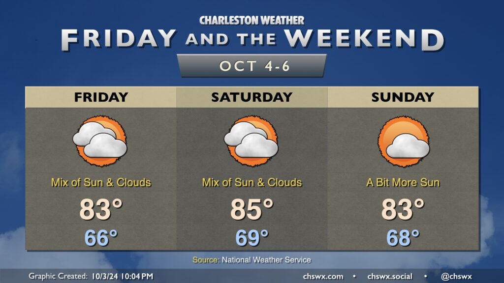
Not terribly much to write home about in the weather department this weekend as our weather looks generally quiet with above-normal temperatures expected. A bit more cloud cover works into the area Friday, with a stray shower possible at the coast in the morning. Otherwise, we stay rain-free for the foreseeable future as dry air aloft keeps a lid on shower activity. Temperatures on Friday start in the mid-60s, warming to the low-to-mid-80s in the afternoon.
Saturday runs a little warmer ahead of a weak front that’ll pass by with relatively little fanfare. A mix of sun and clouds is expected throughout the day, but once again, shower activity should be suppressed this far north. We start the day near 70°, warming to the mid-80s in the afternoon, likely a couple clicks higher than we will on Friday.
Post-frontal skies on Sunday will trend a little sunnier, with morning lows in the upper 60s warming to the low 80s in the afternoon. All in all, the next few days look pretty alright weather-wise.
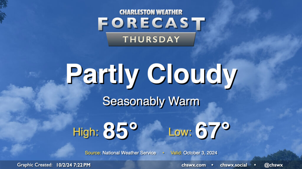
Quiet and seasonably warm weather continues for Thursday. We’ll start the day in the mid-to-upper 60s, warming to the mid-80s in the afternoon under partly cloudy skies. Dewpoints will run in the upper 60s, so it’ll still feel a touch humid, but it won’t be too bad overall. The only weather-related issue we could run into tomorrow would be a little bit of salt water on the roads around the 9:01am high tide. Water levels should peak around 7′, which is right where we generally start to see coastal flooding occur. Widespread impacts aren’t expected, but the usual trouble spots may once again be troublesome, particularly around Hagood and Fishburne.
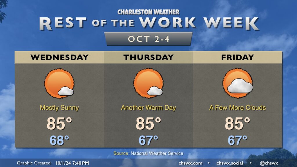
High pressure will be in control of our weather for the rest of the week both at the surface and aloft, bringing in quiet and seasonably warm conditions with a fair bit of sunshine, especially on Wednesday and Thursday. Temperatures each day start in the upper 60s, warming to the mid-80s each afternoon.
Rain chances will run essentially nil until late next weekend as a series of fronts move on by. These fronts should keep an area of low pressure in the Gulf of Mexico well to our south. While it may sling some moisture our way, any outsized impacts are not expected, and we actually have another round of slightly cooler and quieter weather expected by the middle of next week.