Jared Smith founded @chswx on Twitter in 2008 as an experiment in disseminating weather data through social media. In the ensuing decade-and-a-half, @chswx has provided live coverage of tropical cyclones, tornadoes, severe weather, and even a couple bouts of winter weather to the good people of Charleston, SC.
We have another hot day ahead on Sunday before showers and thunderstorms erupt once more generally in the mid-to-late afternoon and evening hours. Lows in the mid-to-upper 70s will warm to the mid-90s in the afternoon. Ever-so-slightly drier air should keep heat indices below 105° and delay the onset of thunderstorms later than they started on Saturday. Storm coverage also should be a little thinner than Saturday as well. Still, a strong to severe storm can’t be totally ruled out, so stay alert for possible warnings, and just be ready to change outdoor plans to indoor ones if a thunderstorm approaches your area.
“Speak Now” (Taylor’s Version) is not the only thing that’s going to get replayed over and over this weekend — so it shall be with the forecast as well. Expect muggy starts in the mid-70s each morning (with temperatures struggling to get below 80° downtown) followed by high temperatures in the mid-90s each afternoon. Heat indices will peak around 105° each day. While that would be a Heat Advisory in June, it happens so frequently in July and August that the criteria is moved to 110° on July 1. So, even though there’s no advisory, the risk for heat stroke is elevated in the afternoons.
From there, scattered showers and thunderstorms will fire along and ahead of the seabreeze as convective temperatures are reached, eliminating the cap that we’ll start the day with. Heavy rain and frequent lightning from slow-moving storms are the main concerns, and these will once again be mostly pulse-type storms (essentially pop up and fizzle out, much like Friday’s storms) with very weak wind shear in place. However, a damaging wind gust or two can never be totally ruled out where outflow boundaries get together and help improve lift, leading to stronger storms.
All in all, don’t expect a washout, but just be ready to move outdoor activities indoors at a moment’s notice. And stay hydrated!
Afternoon showers and thunderstorms remain in the forecast for Friday and the weekend with an active seabreeze and plenty of heat and humidity. Highs each day will top out in the low to mid-90s, with heat indices over 105° expected. Sunday’s heat index could approach 110°, in fact. Airmass showers and thunderstorms will be possible in the early afternoon, with more activity kicking up along the inland-moving seabreeze as we head into the evenings. As always, keep up to date with forecast changes as small tweaks — such as the pocket of drier air aloft that enveloped the area Thursday, which kept thunderstorms to a dull roar — could mean a better (and vice versa) day of weather.
More showers and thunderstorms are forecast for Thursday afternoon as a warm and humid atmosphere remains firmly in place across the area. Temperatures will warm to the low-to-mid-90s before storms start to kick up after convective temperatures are met. Shear is weak and instability is about average, but there will still be plenty of moisture to wring out of the atmosphere, so expect frequent lightning and heavy rain with the stronger of Thursday’s thunderstorms. There will be the risk for storms to anchor a bit and rain a lot in one spot as westerly flow aloft fights against an inland-moving seabreeze. (Daniel Island knows all about this, with several stations on the island recording 2-3″ of rain in a couple hours’ time.) A damaging wet microburst or two can’t be discounted either especially near where outflow boundaries collide. Once again, keep an ear out for warnings and take it easy on the commute.
One more round of coastal flooding is possible with the Thursday night high tide at 11:43 PM. Expect water levels between 7.1-7.3′ to produce some minor flooding generally between 9 PM-1 AM. A Coastal Flood Advisory will likely be issued. From there, the astronomical influences of the full moon will wane further, and while water levels may get close on Friday night, we should be done with this round of king tides.
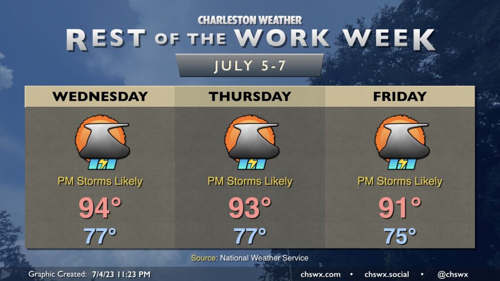
The rest of the work week will remain rather unsettled as very humid air remains in place across the area and impulses continue to ripple aloft.
Hot and humid conditions will continue for the foreseeable future, with abatement coming in the form of seabreeze showers and thunderstorms each afternoon and evening. Temperatures will generally run in the mid-90s on Wednesday and perhaps Thursday, then backing down a little to the low 90s on Friday. Heat indices will continue to run above 105° each afternoon through at least Thursday due to the combination of warm air temperatures and mid-70s dewpoints.
Thunderstorms each afternoon will be capable of very heavy rain in a short period — there were reports of nearly 3” in an hour in a few spots on Tuesday — and excessive lightning. Damaging wind gusts will be possible in the strongest storms, though a widespread severe weather event is not expected.
Finally, we’ll continue to deal with the potential for coastal flooding with the late high tides. High tide on Wednesday is at 10:48 PM; salt water flooding will generally be possible an hour or two on either side of high tide.
We will not get to declare independence from hot weather this July 4th, that’s for sure: After a balmy start in the upper 70s, temperatures will once again head into the mid-90s in the afternoon with heat indices running between 105-110°. Once again, you’re going to want to make sure you’re getting plenty of water and getting in the shade at times. Headed to the beach? Definitely deploy the sunscreen with the UV index forecast to be at 11, in the “Extreme” category.
As we get further into the afternoon and the seabreeze begins to move inland, we’ll see showers and thunderstorms begin to fire in a reasonably unstable environment. A storm or two could be on the strong to even severe side with gusty winds the main concern. Regardless of severity, the lightning a thunderstorm produces makes them all dangerous. This is especially important on a big outdoors day like the Fourth. Remember: When thunder roars, go indoors!
Finally, there will be a risk for minor coastal flooding with high tide around 9:53 PM. This tide has already caused Folly Beach to cancel their fireworks, unfortunately, and may be problematic for other beach displays as well. Be ready to avoid flooded roadways an hour or two around high tide.
Hot weather continues to start the week before yielding to more numerous showers and thunderstorms starting mid-week. (It’ll still be hot and humid, though.)
The weather story of this Fourth of July holiday looks to be the first big heat episode of the season across the Lowcountry. After highs in the low 90s on Saturday, air temperatures should top out in the mid-90s on Sunday, with heat indices running above 105° in the afternoon thanks to dewpoints in the low 70s. There will be a chance for an isolated shower or thunderstorm or two on the inland-advancing seabreeze in the afternoon, but the vast majority of us will stay rain-free — and hot.
The weekend forecast basically screams “first weekend of July in Charleston.” Morning lows bottom out in the mid-70s, while highs reach the mid-90s each afternoon with a few showers and storms possible along and ahead of the seabreeze. Humidity will be on the increase throughout the weekend. Heat indices on Saturday top out around 100-101°. On Sunday, the dewpoints head into the mid-70s and sends the heat index to around 106° in the afternoon. By virtue of it being July 2nd, there will not be a heat advisory as the criteria heads up to 110° on July 1, but anything past 105° is dangerous heat, and you should take the appropriate precautions.
The only potential fly in the ointment could arrive late Saturday/early Sunday as a thunderstorm complex rounding a ridge of high pressure approaches the area. It should be weakening, but a couple models suggest that it could hang on to bring some overnight/early morning rain. These are hard to pin down beyond a day or so, so stay tuned to forecast updates. For now, though, the going forecast for isolated PM thunderstorms looks solid.
Here comes real summer: Humidity begins to increase Friday as winds go more southerly at the surface, and will continue to build heading into the weekend. Highs on Friday top out in the mid-90s once again, and with dewpoints just shy of 70°, expect heat indices to approach 100° in the afternoon. We could see a shower or storm in the afternoon to evening hours along the seabreeze (and possibly as a result of a decaying convective complex headed toward the Carolinas), but most of us should stay dry.
Similar weather is on tap for Saturday, but with dewpoints a few clicks higher, expect heat indices to top out around 102° or so. Once again, we could see a shower or storm in the afternoon, but the vast majority of us should get away with the day rain-free.
By Sunday, dewpoints will top out in the mid-70s, and this combined with solid mid-90s temperatures could drive heat indices near 110°, which is the Heat Advisory threshold after July 1. A stray shower or storm can’t be ruled out, but the odds favor dry weather for now. We’ll want to keep an eye on potential thunderstorm complexes rounding a ridge of high pressure that’ll be making gradual eastward progress toward the area, so stay tuned to forecast updates as these are hard to catch beyond a day or so.