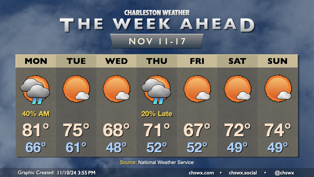
A couple fronts this week will finally restore some order to temperatures that have been well above normal to start November. But first, we’ll get one more day in the 80s on Veterans Day with scattered showers to start the day, which will gradually taper by evening as a cold front moves through the area. This front helps knock temperatures back down to the low 60s Tuesday morning, warming to about the mid-70s in the afternoon under mostly sunny skies.
High pressure to the north will then shift a little eastward, allowing for a wedge pattern with northeasterly winds to start to take shape. This will drive temperatures down to — if not slightly below — normal for Wednesday. We’ll start the day sharply cooler — think upper 40s to around 50° — before warming to the upper 60s, once again under mostly sunny skies.
Another front swings through on Thursday. We’ll turn a little warmer ahead of it, and there may be a few showers associated with it. We start Thursday in the low 50s, warming to the low 70s in the afternoon.
Cooler and drier air behind the front moves in for Friday, and we see highs once again running a touch below normal (upper 60s). The airmass moderates a bit heading into the weekend, which looks quite seasonable and nice with lows in the upper 40s yielding to highs in the low 70s each afternoon under mostly sunny skies.
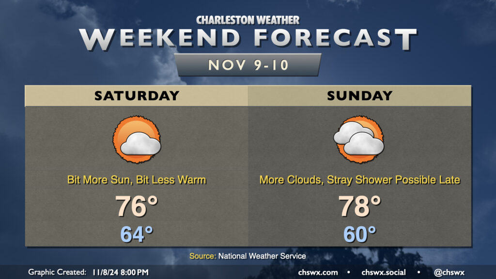
A cold front will sag southward over the area overnight, taking the edge off some of this very unseasonable warmth (which included tying the record high of 85° at the airport today). We’ll still stay warmer than normal this weekend, though, as a more substantial airmass change remains largely out of reach for now.
Saturday starts in the mid-60s as high pressure pushes south into the area. Northeasterly winds will kick up a touch, and this will help keep temperatures from getting too far beyond the mid-70s in the afternoon despite a good bit of sunshine. It’ll be noticeably drier, too: the absurd-for-November 70s dewpoints get shunted southward in favor of drier air characterized by dewpoints in the upper 50s.
The reprieve is somewhat short-lived, though, as the parent high heads offshore, allowing a coastal trough to sharpen and move ashore Sunday. We start Sunday around 60°, but will warm back into the upper 70s in the afternoon with increasing cloud cover along with dewpoints heading back into the mid-60s. A shower or two will be possible as we head into Sunday evening, and that risk will hang around through Tuesday.
Looking ahead, we see next week continuing to generally feature above-normal temperatures for the first half, but a front should swing through late week that will knock temperatures back closer to November normals in time for the weekend.
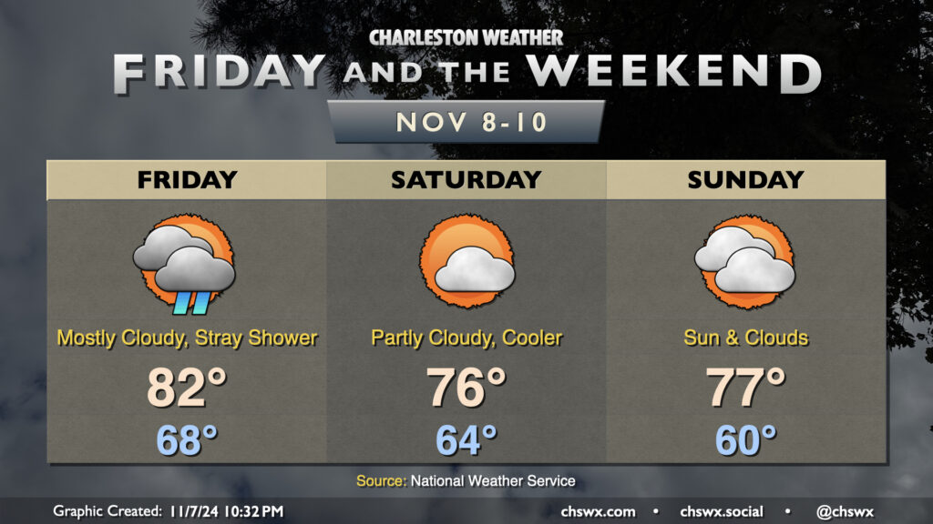
A brief respite from the really unseasonable weather arrives this weekend behind a front, but first we deal with Friday and the potential for a shower or two along with one more day of very warm temperatures. Expect lows in the upper 60s to yield to the low 80s in the afternoon with a mix of sun and clouds around the shower activity.
A front gets through later Friday, though, and this begins to temper things a little bit — though by no means anywhere near where we should be for this point in November. Expect a fairly nice day on Saturday, though, with lows in the mid-60s warming to the mid-70s in the afternoon under partly cloudy skies. A few more clouds arrive on the scene for Sunday, but we should stay rain-free again, with lows around 60° warming to the upper 70s in the afternoon.
We’ll briefly return to the 80s early next week before a front moves by on Tuesday. This front will help take the edge off some of the warmer temperatures, getting us much closer to mid-November normals, but still on the warm side of normal, with highs in the low to mid-70s and lows in the mid-50s expected starting around mid-week.
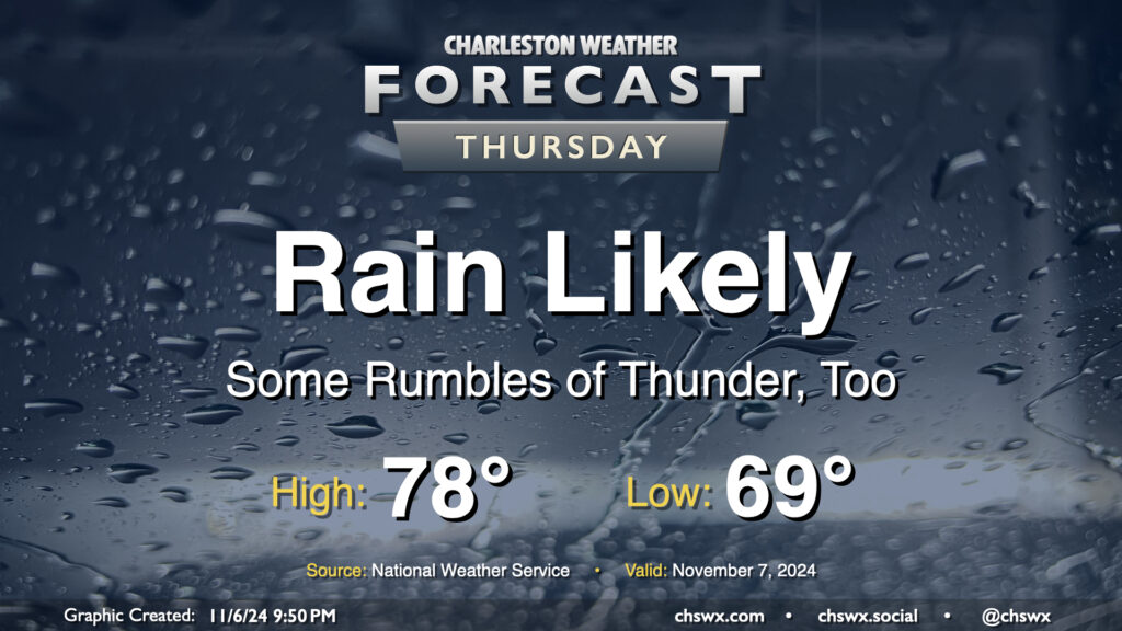
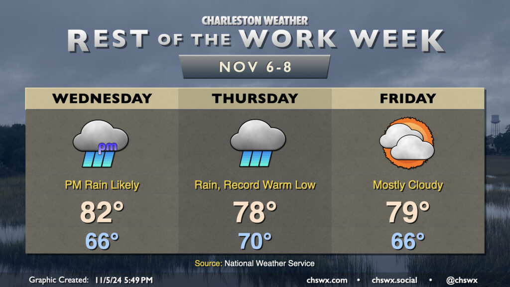
Rain continues on Thursday as northward-moving moisture from Hurricane Rafael interacts with a front. As far as average temperature goes, it’s going to be a particularly warm November day: expect to start the day in the upper 60s to around 70°, with highs topping out around 78° (largely governed by the expected rain). If it verifies, the low of 69° would be a new record warm low temperature for November 7, breaking the record of 68° set in 2018.
Rainfall totals should continue to climb across the area, with another 1-2″ possible across much of the metro overnight into Thursday evening. Expect the best chances for rain during the morning, with some scattering of the activity as we get into the afternoon and evening hours. Flooding doesn’t look to be a major concern here, but if training of rain does occur, some localized issues can’t be ruled out.
Many stations recorded a good bit of measurable rainfall yesterday, and it looks like we have another round of it coming Wednesday evening into Thursday courtesy of the interaction of Tropical Storm Rafael in the Gulf and a cold front. Meanwhile, the airmass remains awfully tropical for early November, and we should set a new record warm low temperature on Thursday as a result.
Wednesday will start out quiet and mild (mid-60s lows expected), but expect showers to increase across the area as we get into the afternoon and evening hours, including around the evening commute. Temperatures top out in the low 80s before rain overtakes the area. We could even hear some rumbles of thunder thanks to the spring-like dewpoints around 70-72°.
Rain continues on Thursday and should be around for much of the day. We start the day around 70° — which would be a record warm low for the date — and warm only to around the upper 70s given the cloud cover and ongoing rainfall. Many spots will end up with 1-2″ of rain before this is over, with even higher amounts possible west of 26. It’s much-needed rain, and given that it’s been so dry, the flooding risk is low (provided pockets of heavier rain don’t train over the same urban areas).
High pressure builds back in for Friday and into the weekend, giving us a chance to dry out. Warmer-than-normal temperatures will persist, with highs in the upper 70s to low 80s continuing each day well into next week.