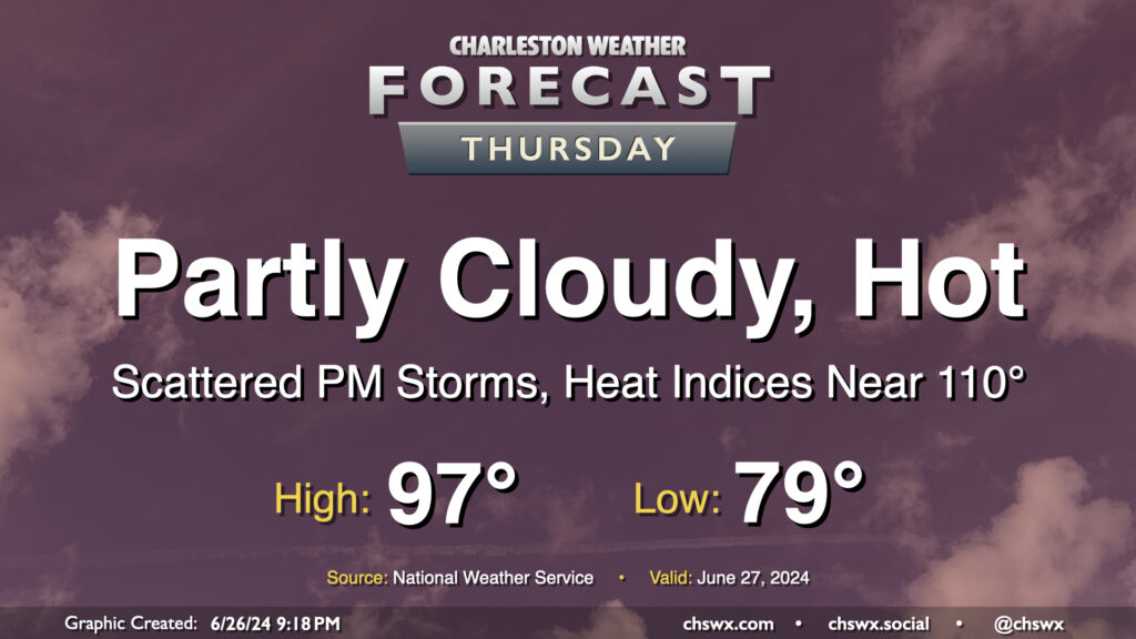
The meteorological status quo continues on Thursday: Heat, humidity, and a few storms in the afternoon. Temperatures will be fairly heinous on Thursday, with lows barely dipping below 80° away from the warmer coastline and highs getting into the mid-to-upper 90s in the afternoon. Mix in dewpoints in the mid-70s, and that’ll yield another day of dangerous heat indices in the 107-110° range. I’d be ready for yet another Heat Advisory to be issued for tomorrow.
A front sinking southward into the area combined with the usual seabreeze influence will help improve shower and thunderstorm chances for more of us tomorrow afternoon and evening. Pockets of heavy rain will be possible, and some gusty winds will be possible in any thunderstorm as well. A stray Severe Thunderstorm Warning certainly is in the cards, but widespread severe weather isn’t expected.
Heat and humidity continue for the rest of the week, with advisory-level heat indices remaining a distinct possibility, broken up only by isolated to scattered afternoon and early evening thunderstorms.
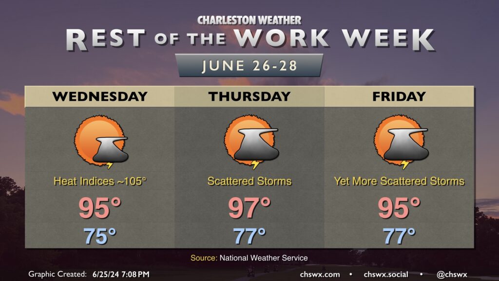
We’re back into the mid-90s Wednesday after a mid-70s start. Heat indices in the mid-100s will be common, with higher values possible closer to the coast where dewpoints will run a little higher. Don’t be surprised if another Heat Advisory comes out for Wednesday. A few of you could get lucky and get a thunderstorm to help cool things off, though the winds could be a bit strong at times in these. However, as is common with the summertime weather regime around here, widespread severe weather is not expected.
We’ll keep this going Thursday into Friday. Air temperatures peak on Thursday, topping out in the mid-to-upper 90s as winds go a little more westerly through about 5,000 feet. Once again, isolated to scattered showers and thunderstorms are possible in the afternoon as convective temperatures are reached and the seabreeze makes a slow push inland. Expect similar conditions Friday, with highs once again topping out in the mid-90s after an upper 70s start, with just a few showers and thunderstorms perhaps imparting relief.
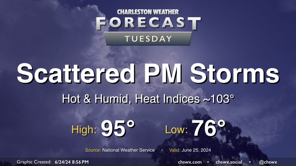
Another hot summer day lies ahead for Tuesday, with just a few of us possibly seeing some relief from thunderstorms in the afternoon. We start the day in the mid-70s, warming to the mid-90s in the afternoon. Dewpoints in the low to mid-70s will make it feel closer to 103° at times, with even warmer heat indices possible in the wake of the seabreeze.
As mentioned, a few thunderstorms will be possible with a stalled front in the area, but not everyone will see a storm. A stronger storm or two can never be ruled out this time of year, but there is not a widespread risk for severe weather.
Charleston summer is in full swing as we get into the last week of June as hot and muggy conditions will be prevalent for the foreseeable future.
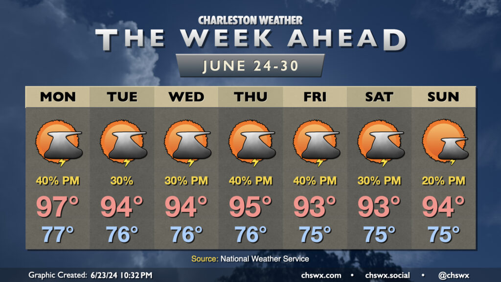
Monday will be particularly warm with westerly winds ahead of a front that’ll be sagging southward throughout the day. This front along with the pinned seabreeze should help ignite some showers and thunderstorms in the afternoon, but not everyone’s going to get heat relief. We start the day in the mid-to-upper 70s, warming to the upper 90s in the afternoon with heat indices around and even a little above 105° expected. (Note: 105° used to be heat advisory criteria, but that has changed this year — 108° heat index or higher for two hours is the new heat advisory criteria.)
The front hangs around Tuesday before retreating northward Wednesday. This should generally lead to standard afternoon thunderstorms along and ahead of the seabreeze each day. Highs continue in the mid-90s after mid-70s starts both days, with heat indices once again potentially approaching 105°. Rain chances tick up Thursday and Friday as a disturbance moves across the area, while ridging builds aloft for the weekend and starts to reduce afternoon storm chances. Highs continue in the low to mid-90s each afternoon after mid-70s starts, with heat indices flirting with the Heat Advisory criteria especially later in the work week. Be sure you’re taking frequent breaks and hydrating if you’re working outdoors in this swampy weather!