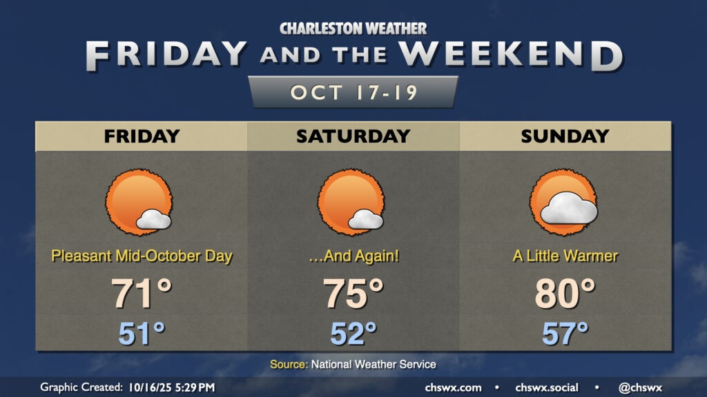
High pressure remains the main weather player in our neck of the woods, keeping things generally quiet and seasonable for Friday and the weekend. You may need a light hoodie or somesuch Friday morning as lows bottom out to the low 50s in the metro and perhaps into the 40s further inland and in more rural locations. Highs Friday peak in the low 70s with plenty of sunshine expected.
High pressure starts to move a bit more overhead Saturday and then starts to slip offshore on Sunday. This will lead to gradually warming temperatures through the weekend; mid-70s Saturday while we should touch 80° on Sunday. Generally speaking, mostly sunny skies will prevail, though there could be an uptick in cloud cover later Sunday as a front approaches. A stray shower will be possible overnight Sunday into early Monday morning, but otherwise, we look to stay dry well into next week.
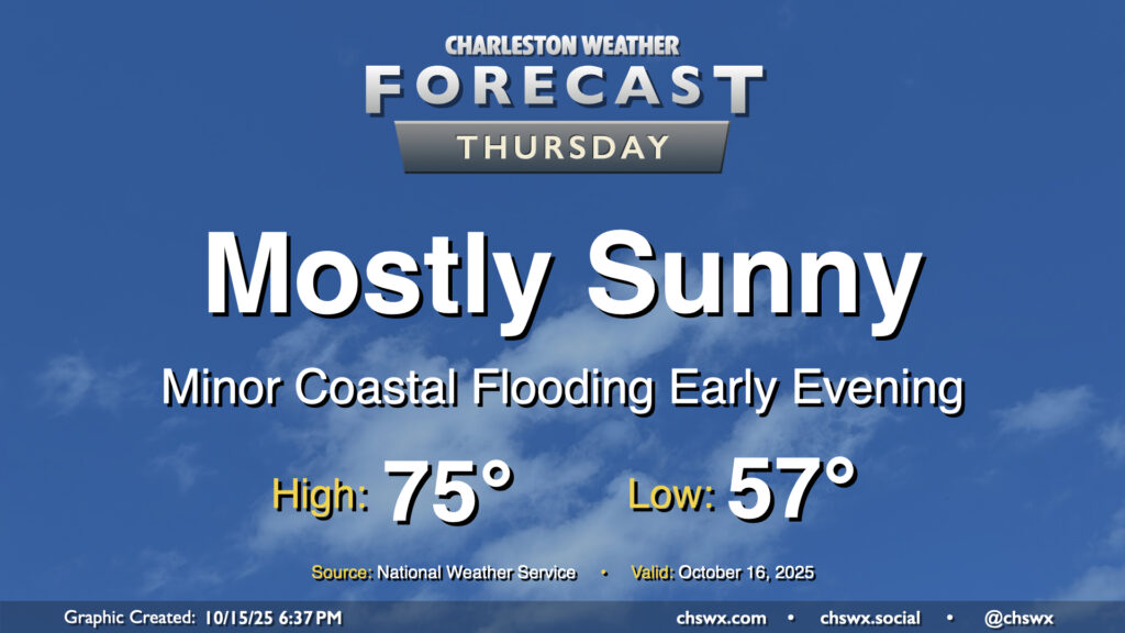
Mother Nature’s apology for the nor’easter continues Thursday with another day of comfortable temperatures and plenty of sunshine expected. A weak, dry front moves by early in the day, and so we should see temperatures start and peak a little cooler than we did on Wednesday. Expect lows in the mid-to-upper 50s warming to the mid-70s under mostly sunny skies. Winds will swing around to the northeast and pick up a little bit, and this could drive some minor coastal flooding with the early evening high tide cycle. A Coastal Flood Advisory is possible, but impacts beyond the most vulnerable locations downtown will be minimal.
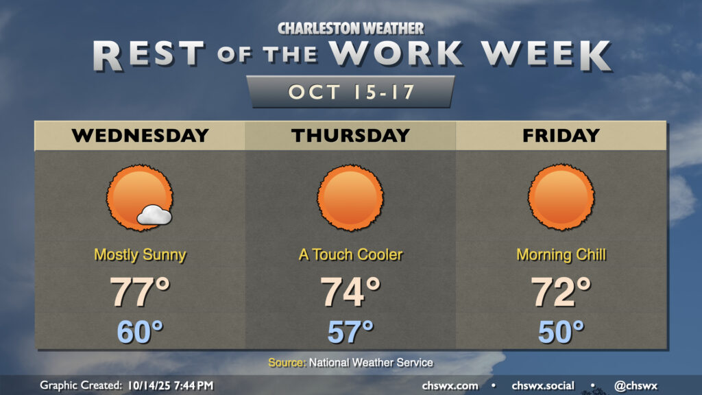
Pleasant weather continues for the rest of the work week as high pressure remains in control. A dry front will move through overnight Wednesday into early Thursday, bringing along a reinforcing shot of cooler and drier air that will make for a crisp start on Friday.
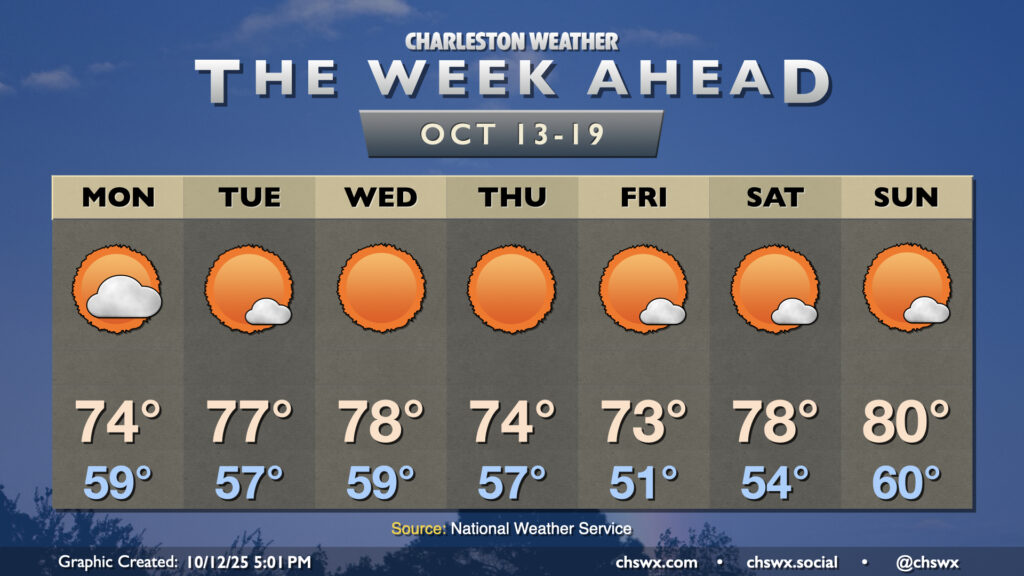
The nor’easter that has made for several soggy days across the metro will finally be pulling away on Monday, yielding a beautiful week of weather across the area with plenty of sun and comfortable temperatures.
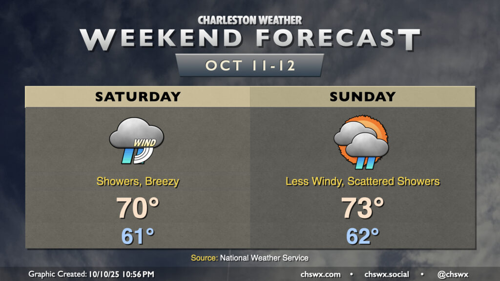
The nor’easter that drove the highest tide of the year on Friday will continue to affect our weather Saturday and to a lesser degree on Sunday. Showers will continue overnight through much of the day on Saturday, and gusts will continue to head into the 25-30 MPH range especially near the coast and on bridges and overpasses. Temperatures remain on the cool side as well, with lows in the low 60s warming to just about 70° at best in the afternoon.
We will also be contending with the risk for moderate coastal flooding once again with the midday high tide. A Coastal Flood Advisory is in effect from 10 AM-2 PM as a result. While this tide will certainly be less severe than we saw on Friday, it’ll still be high enough to close plenty of roads downtown right smack in the middle of the day. Be ready to reroute around road closures as a result.
We’ll see the nor’easter gradually pull away Sunday, though some showers look to persist. Temperatures will still be cooler than normal, with lows in the low 60s warming to the low-to-mid-70s in the afternoon with a little bit more sun breaking through. Winds will be backing off, and this will help mitigate a more serious coastal flooding threat during the day, though we should still see minor to moderate flooding with the early afternoon high tide that could close a few roads.
This will lead into a quieter and sunnier week ahead with high pressure in control. Humidity will be low and temperatures will be comfortably warm, with highs in the upper 70s to around 80° each afternoon.