High pressure will gradually give way to another cold front this weekend, bringing humidity back to the picture particularly Sunday. However, the return to mid-70s dewpoints will be brief as slightly drier air moves back in behind the front next week.
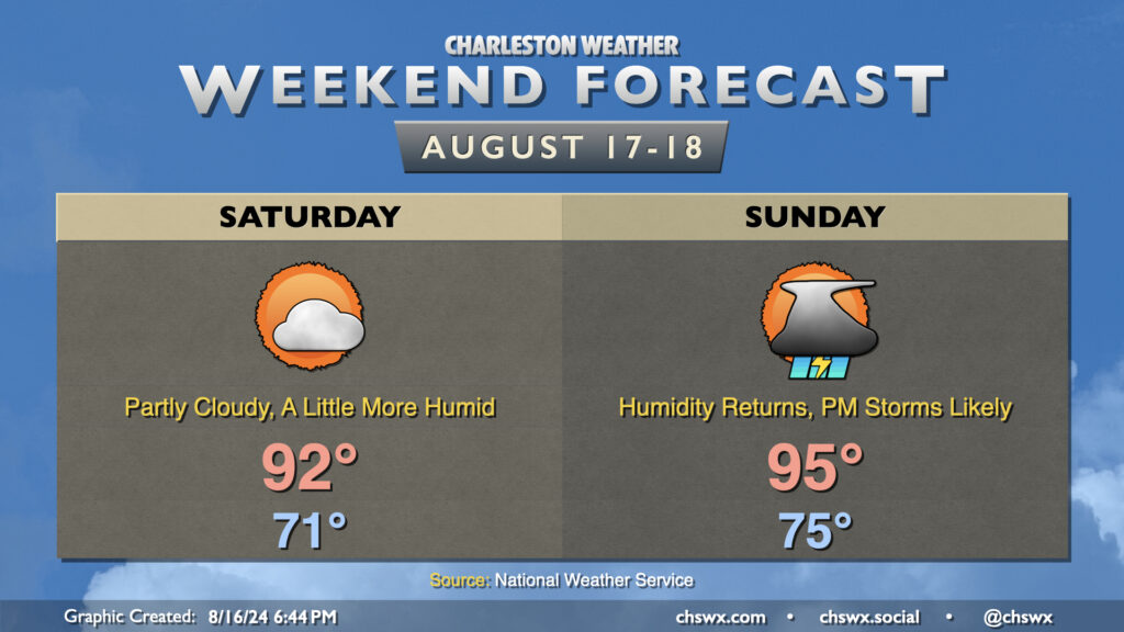
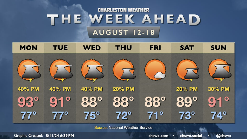
Saturday will run a little warmer than Friday did. After another cool-ish (relatively speaking) start in the low 70s, temperatures warm to the low 90s in the afternoon as dewpoints creep back up to the upper 60s. This will make it feel more like 95° or so — not a huge jump, but certainly warmer than it’s felt the past couple days. Expect rain-free conditions on Saturday with one more day of high pressure in control before it cedes ground to the approaching front on Sunday.
Sunday starts warmer — back to the mid-70s — and warms to the mid-90s in the afternoon. Dewpoints in the low to mid-70s will yield heat indices around 100-102° at the height of the afternoon. As the seabreeze moves inland and the front draws closer, expect showers and thunderstorms to develop. Guidance doesn’t show much to write home about with the seabreeze activity — generally scattered coverage — but a round of thunderstorms ahead of the front looks like a good bet as we get into Sunday evening. Shear and instability will be favorable for a few severe thunderstorms, with damaging wind gusts the main concerns (though some hail can’t be ruled out, either). If we get greater coverage of seabreeze storms, that could lower the severe weather risk locally, but we’ll need to see how that materializes. Keep an eye on forecast updates for Sunday evening, just in case.
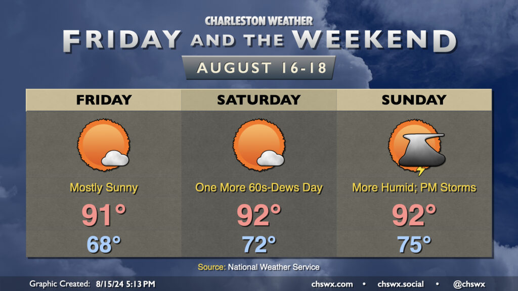
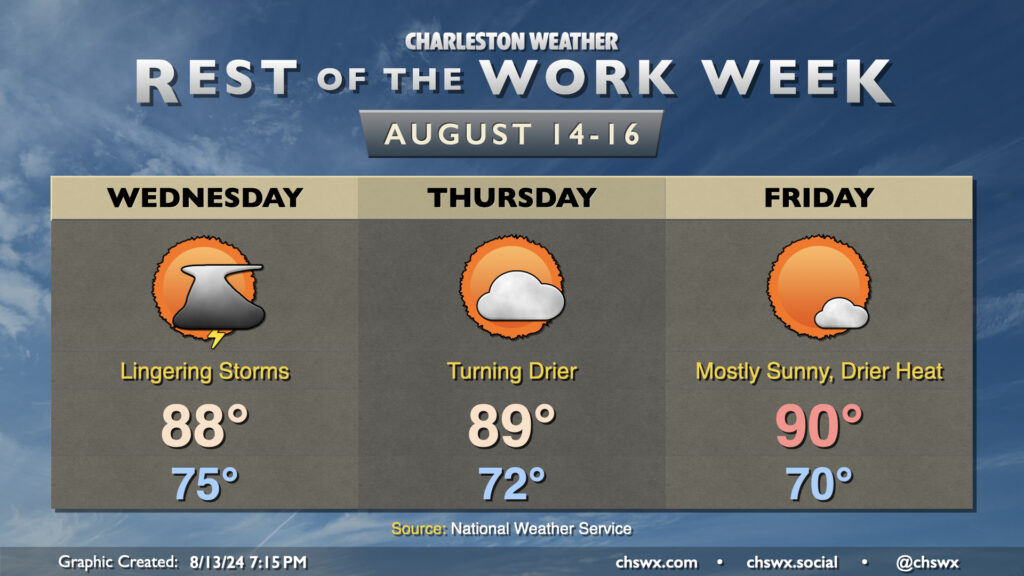
Friday and the weekend look mostly quiet as high pressure remains the main weather player for a few more days. We should start Friday in the mid-to-upper 60s in much of the metro (with low 70s on the coast); temperatures head to the low 90s in the afternoon under mostly sunny skies. With dewpoints in the mid-60s, the heat index could actually run slightly cooler than the air temperature (yes, this can happen!). So, while it’ll still be on the hot side, it won’t be quite as bad as it has been.
Winds go more southerly starting Saturday, and we’ll see a slow uptick in dewpoints as a result, but Saturday still looks quite good. We’ll start in the low 70s, warming to the low 90s in the afternoon under mostly sunny skies once again. Heat indices will run a degree or two warmer than the air temperature, but still generally not too out of bounds especially compared to what we’ve dealt with recently. Dewpoints creep back into the 70s on Sunday, and this will help drive a few scattered showers and storms in the afternoon and evening as another cold front approaches the area. We could see a stronger storm or two, but that’ll depend on the timing of the front. Overall, though, we should have a pretty good weekend of weather. And, given the fact that winds will go more southerly, the risk for coastal flooding is diminished for the upcoming weekend compared to yesterday’s forecast, though a little salt water on Fishburne at Hagood around the evening high tides could still be in play.
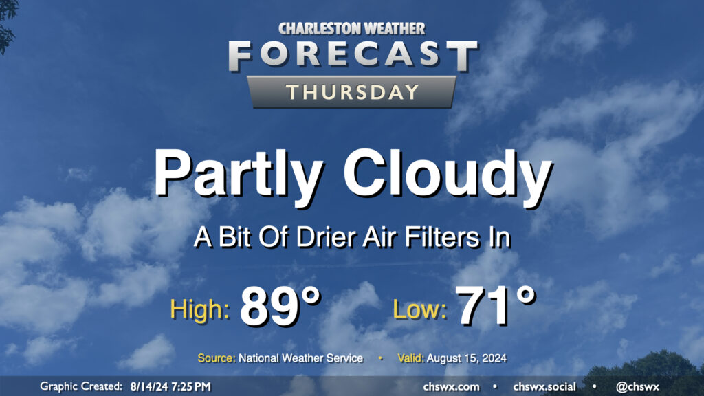
High pressure wedging southward across the area has brought some cooler and drier air to the area this evening, with dewpoints falling into the mid-60s (it’s been a minute!). This will yield a fairly nice (but still warm) day on Thursday. We’ll start the day in the low 70s and warm to the upper 80s in the afternoon under partly cloudy to mostly sunny skies. With the lack of moisture and influence of high pressure, rain isn’t expected (and won’t be for a few days). Overall, not too shabby for mid-August!
We have a bit of a respite from the rain and the extreme humidity on the way as a front slides south of the area and stalls tonight. Some lingering moisture and a trough of low pressure will allow for a few storms to remain in the forecast on Wednesday, though, as dewpoints slowly drop through the low 70s throughout the day. We start the day in the mid-70s and warm to the upper 80s in the afternoon, capped by some of that cooler and drier air trying to move back in. Expect the best chance of showers and storms from roughly 2-10PM. A few downpours can’t be totally ruled out as the deeper moisture only really starts to scour out Wednesday night, so a flood advisory or two could still be possible.
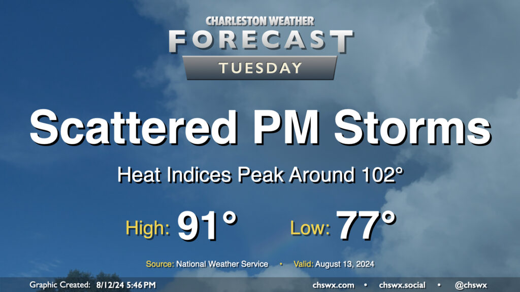
Tuesday’s forecast will continue to feature warm temperatures and afternoon thunderstorms as Berkeley and Charleston head back to school. We have another warm start ahead of us — generally expect lows in the upper 70s once again, followed by highs in the low 90s in the afternoon. This should run a couple degrees cooler with a little more onshore flow, but it’ll still be toasty with heat indices peaking around 102° before showers and storms fire. Once again, heavy downpours could cause localized flooding, especially near swollen rivers and streams and in urban areas, so stay alert for possible Flood Advisories.
Well, there will be decidedly fewer tropical cyclones impacting the area during the upcoming week, though we will still be living with flooding from Debby for the next few days along the Edisto and Ashley rivers as they continue to fall slowly from record (or very near-record) levels. We at least have something to look forward to as we head into the first school week of the year: some drier air punching in for late week.