The week ahead: Below-normal temperatures continue with a brief break in the rain
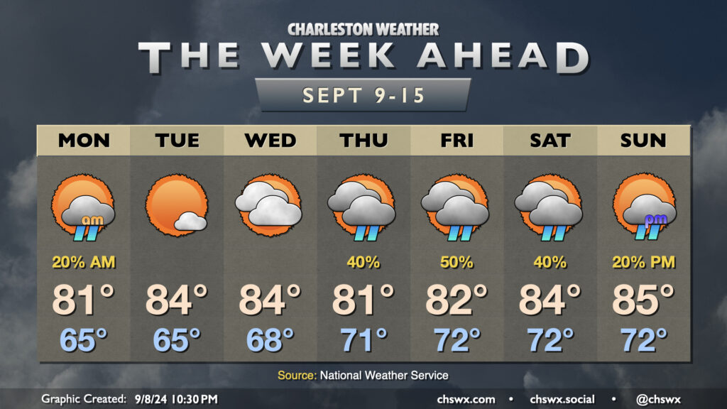
Below-normal temperatures will continue this week as we remain under in the influence of high pressure anchored to the northeast, with showers taking a break for a few days before returning to the forecast for the weekend.
A few lingering showers will be possible Monday morning with a stationary front nearby, though high pressure will continue to nudge that front further and further south, clearing us out for a couple nice days. Mostly cloudy skies keep highs capped to the low 80s on Monday after a mid-60s start, but we should see gradual reduction in cloud cover throughout the day. Tuesday looks to be rather nice, with lows in the mid-60s yielding to highs in the mid-80s under partly cloudy to mostly sunny skies. We’ll start to see the front to our south buckle a little more as low pressure — which is forecast to become Hurricane Francine — moves toward the Louisiana Gulf Coast during the middle of the week. This will net us an uptick in cloud cover and dewpoints for Wednesday, but we’ll get one more rain-free day in.
The high pressure center to our northeast that’ll give us a relatively quiet start to the week will be nudged eastward, which will allow the persistent stationary front to retreat a bit northward. This will bring an uptick in shower chances beginning Thursday and lasting into at least Saturday. It won’t rain all the time, but you’ll want to consider indoor plans as a backup to any outdoor plans. High temperatures will head down a bit with the uptick in cloud cover and showers, with highs in the low 80s expected Thursday and Friday before winds get a little more due-east, bringing some warmer temperatures back to the area for the weekend. Still, though, we stay below mid-September norms, generally running in the mid-80s Saturday and Sunday.
Read more »