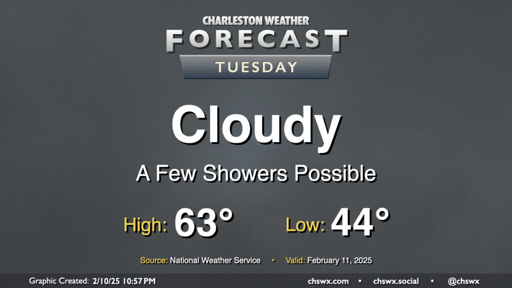
A wedge of cool high pressure hangs tough on Tuesday, bringing another gray and cool day to the area. Temperatures start in the mid-40s, warming to the low 60s in the afternoon — right around normal for this point in February. There’s going to be a risk for some showers from time to time, but an all-day rain isn’t expected.
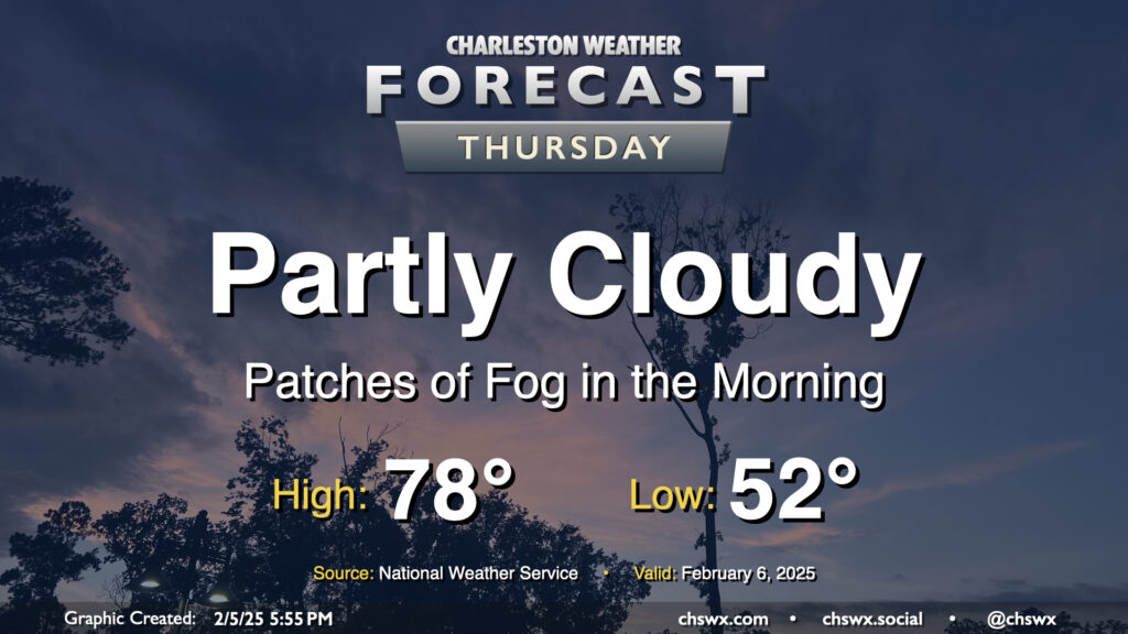
Record warmth will be possible once again Thursday as the wedge of high pressure that cooled us off on Wednesday — highs only topped out around 70° as opposed to 82° the day before — retreats northward as a warm front moves through Thursday morning. This will help disperse the cloud cover throughout the day, and temperatures should respond nicely by heading into the upper 70s. The forecast currently calls for at least tying the record high of 78° set in 2019, so we’ll see how that ends up working out.
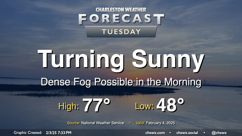
Sea fog will come ashore overnight and cause visibility issues especially near the Highway 17 corridor and points east. A Dense Fog Advisory will be in effect from 8PM Monday to 9AM Tuesday as a result. Use those low beams and allow plenty of space between you and the car in front of you.
Winds will go westerly and pick up after sunrise, which should escort the sea fog back offshore for the most part. This will allow temperatures to soar into the mid-to-upper 70s in the afternoon under mostly sunny skies. The exception will be at the immediate coast, where the seabreeze will help keep much cooler temperatures as well as continued sea fog in place. So, if you’re thinking “early February beach day,” just keep in mind that you’ll probably not be getting much sunshine.
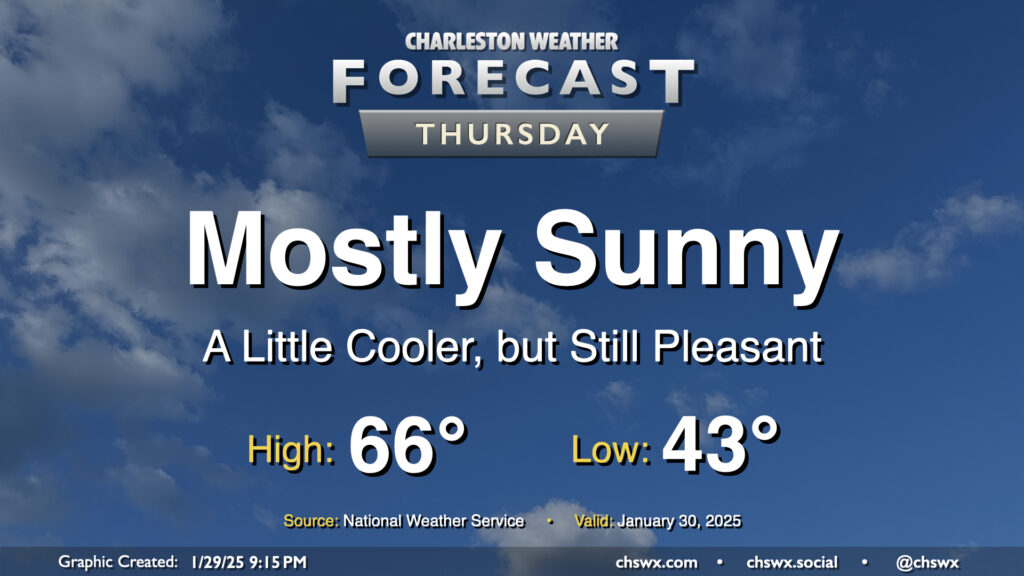
After the warmest day of 2025 so far, in which we reached 72° at the airport and 70° downtown, a dry cold front knocks our temperatures down a few degrees for Thursday, but it’ll still feel quite good outside. Expect mostly sunny skies to help low temperatures in the low-to-mid-40s warm to the mid-60s in the afternoon. An easterly wind at 10 MPH will keep things a touch on the breezy side, but otherwise, no concerns for Thursday.
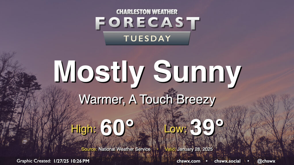
Tuesday will feel a lot better than Monday did as a front swings through with mostly a drier airmass, but not nearly as cold as the one we dealt with last week. We start the day in the upper 30s and warm to around 60° in the afternoon under mostly sunny skies. The black ice threat has ended, especially after Monday’s rain melted much of the rest of the snowpack and any lingering ice patches. If you have some snow left, it won’t be much longer, especially as we get into a warming trend this week.
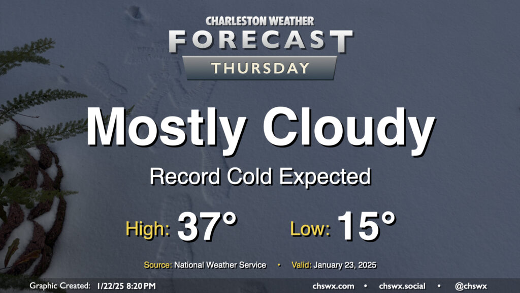
With plenty of snowpack still on the ground, expect a very, very cold night that should set daily records on Thursday morning as lows could fall to as low as 15°. Mix in the persistent northerly wind and wind chills may fall into the single digits. If you’re headed outside tomorrow morning, be bundling up in lots of layers and be very careful for re-frozen ice on steps, sidewalks, and roads.
Additional cloud cover on Thursday isn’t gonna do us a lot of good in the melting department; highs should once again only peak in the upper 30s with mostly cloudy skies generally expected. Wind will remain a bit of a factor, and it’ll feel like the 20s for much of the daytime period.
Getting into Thursday night, I’d expect another round of refreezing and black ice concerns. If you don’t have to travel, it’s probably best to stay hunkered in one more day.
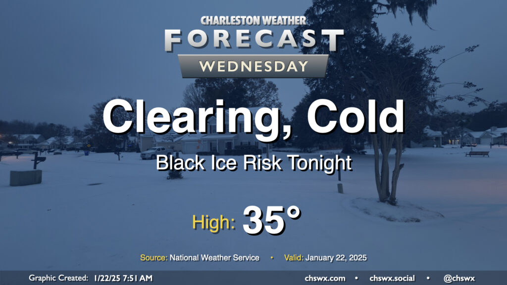
Precipitation has ended across the Lowcountry after an eventful night of winter weather. Snow totals are coming in and a more complete analysis will be doable later today. For now, though, it’s quite cold, and will stay that way for much of the day with so much sleet/snow cover. Cloud cover will clear out, which may be the only thing that gets us back above freezing this afternoon for a brief period. Anything that melts will likely re-freeze, though, promoting a black ice risk across the area especially on bridges and overpasses. (We have a few days of this ahead, too.) If you don’t have to travel, don’t — quite a few roads, including the Ravenel Bridge, Ashley River bridges, and the Northbridge are closed to traffic. Monitor local media for updates on roads throughout the day — and try to have a little fun, too!
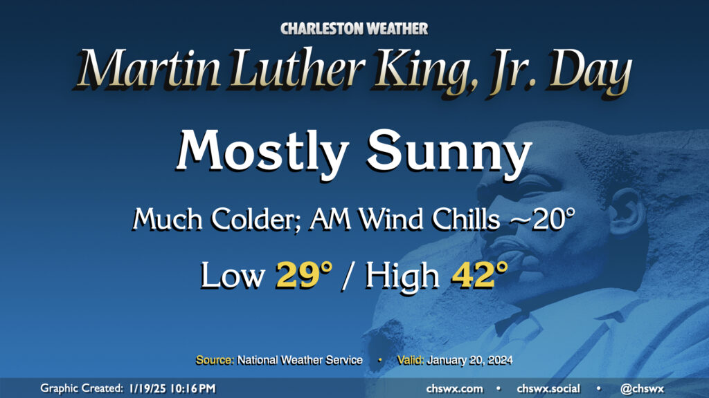
Arctic air will be spilling into the area for Martin Luther King, Jr. Day, bringing the first of several cold days to the Lowcountry. This one will at least come with some sunshine, but even despite that, highs only peak in the low 40s after an upper 20s start. Factor in the wind chill and it’ll feel closer to 20° in the morning, and like the 30s for the balance of the day. Layers will be necessary on Monday and for the next several days as the cold airmass takes residence.
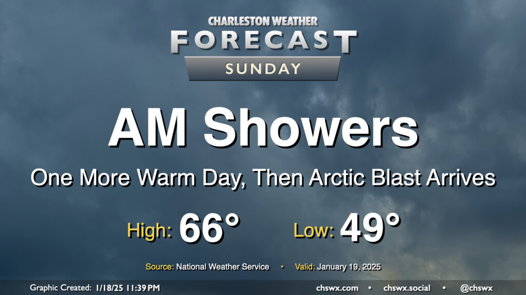
Showers will be ending by early Sunday afternoon as a cold front sweeps through the area later in the day, the forerunner to a much colder Arctic airmass that will arrive overnight Sunday into Monday, setting up a period of impactful winter weather starting Tuesday afternoon.
Temperatures on Sunday will be as warm as they will be for the forecastable future, with highs peaking in the mid-60s early in the afternoon after a start near 50° before falling off post-frontal passage later in the afternoon. We’ll get some peeks of sun as we head through the afternoon and early evening before sunset as much cooler and drier air filters into the area behind the front.
We remain on track to have a relatively quiet but cold day of weather on Monday before winter weather in the form of freezing rain and snow starts to affect the area beginning Tuesday afternoon through Wednesday. I’ll have a more in-depth look at this with Sunday evening’s post as we start to get more of the high-resolution data in, but long story short, we’re quite possibly going to see the most impactful winter weather in the area since 2018 this week. Stay tuned!
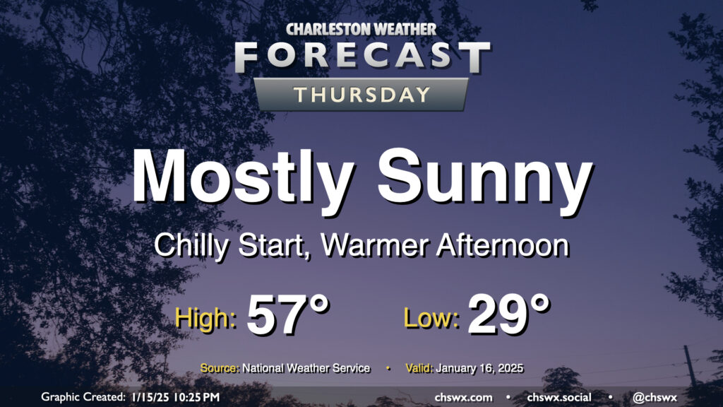
We start Thursday in the upper 20s to low 30s across the metro, but temperatures will ultimately end up a few degrees warmer than Wednesday under mostly sunny skies. This will be the second to last day of generally quiet weather before an unsettled period begins this weekend and lasts into next week, which will turn very cold and perhaps somewhat interesting winter weather-wise, too.