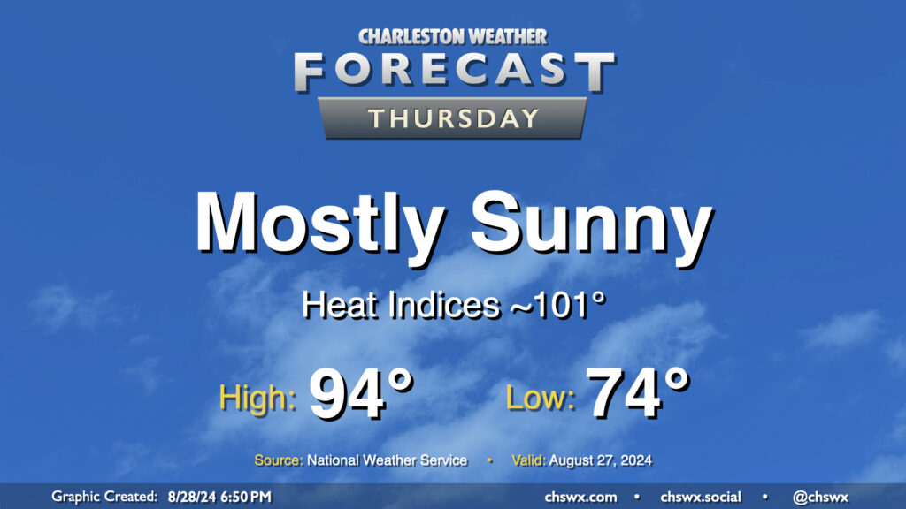
Our stretch of high-pressure-dominated weather continues on Thursday as warm temperatures and mostly sunny skies continue. We start the day in the mid-70s, warming to the mid-90s in the afternoon. Dewpoints in the low 70s will ultimately yield heat indices around 100-101°. A few patches of fog will be possible in the morning, but otherwise, another generally quiet weather day is expected.
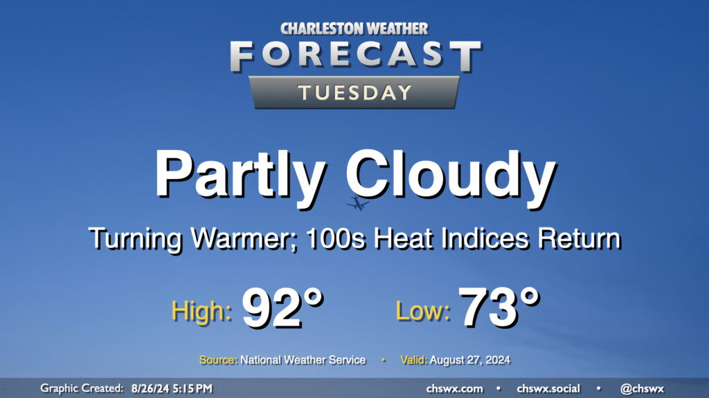
High pressure will bring a pause in the rain and a further uptick in temperatures starting Tuesday. We start the day in the low to mid-70s (warmer near the coast), warming to the low 90s in the afternoon under partly cloudy to mostly sunny skies. With 70s dewpoints continuing their comeback, expect heat indices in the low 100s to return to the area as well — a fair bit warmer than we’ve been used to recently, but staying below the heat advisory thresholds we got to know very well during July.
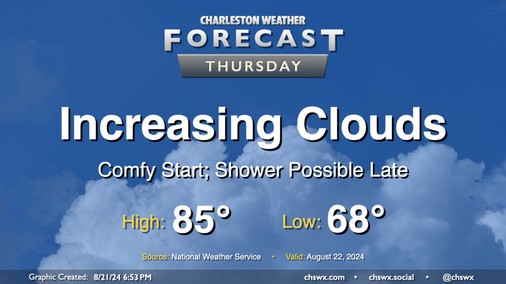
We’ve got a reasonably comfortable day (especially as late August goes) for Thursday as cool high pressure continues to rule the meteorological roost in our neck of the woods. We start the day in the upper 60s in much of the metro, likely dropping even lower further inland and in more rural locations. Temperatures should warm to the mid-80s in the afternoon, but humidity will be quite tolerable with mid-60s dewpoints expected. Clouds will be on the increase as a coastal trough takes shape, and there will be a risk for a shower near the coast, but much of us get the day in rain-free.
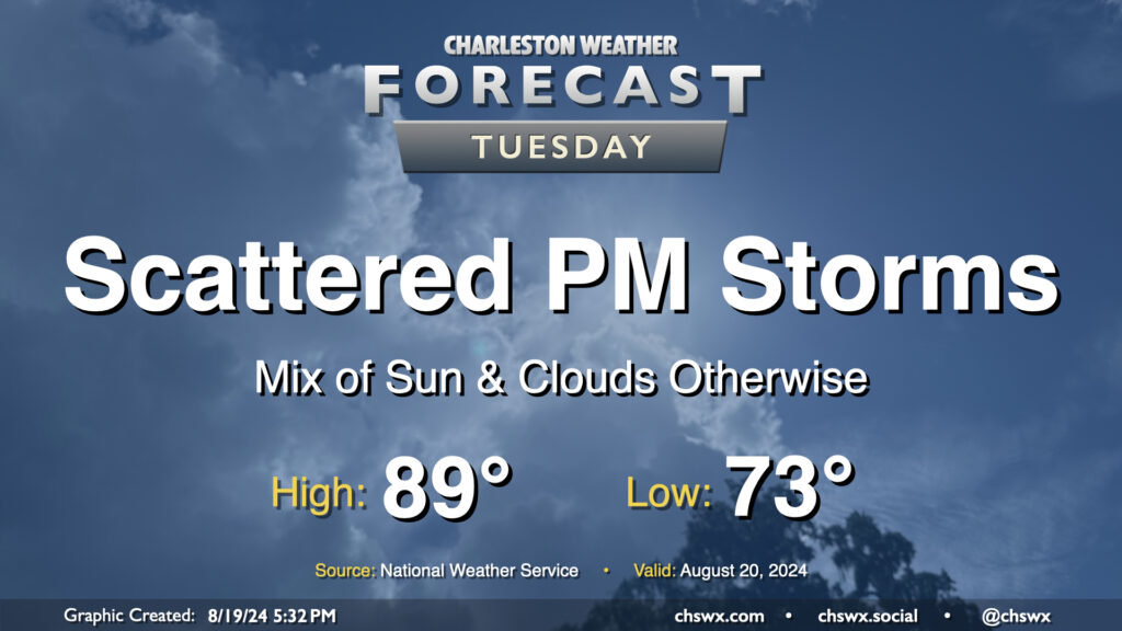
Tuesday looks a lot like Monday did (in the weather department, anyway) as a front continues to meander nearby, keeping the risk for a few showers and thunderstorms in the forecast in the afternoon primarily east of 17-A. Temperatures will follow a similar curve as well — we start in the low 70s (warmer toward the coast) and warm into the upper 80s to around 90° in the afternoon.
As far as storms go, a few folks could see some locally heavy rain thanks to slow storm motions, but otherwise, no severe weather is expected.
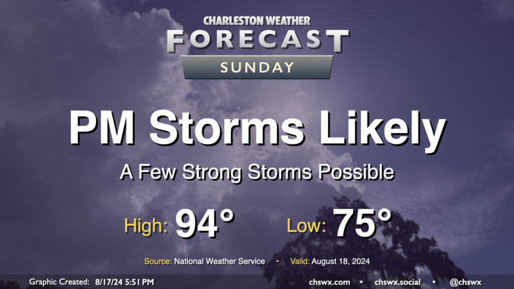
Well, we are back to the heat — briefly, at least — on Sunday as dewpoints head back to the mid-70s ahead of a cold front that could bring stronger storms later in the day. Expect air temperatures to peak in the mid-90s, with heat indices in the mid-100s — shy of the Heat Advisory criteria of 108°, but not by much — at the height of the afternoon.
Attention will then turn to the potential for strong to severe thunderstorms accompanying the front in the late afternoon and evening hours. A thunderstorm complex is expected to develop in the Upstate and will head to the Lowcountry as the day goes on. Given the heat and humidity, the atmosphere looks to be capable of sustaining strong to severe thunderstorms with damaging wind gusts as the main concern. Heavy rain will be a secondary concern, but these storms should be moving fairly quickly so any ongoing flooding shouldn’t worsen. Be ready for conditions to change in a hurry tomorrow evening, and keep an ear out for possible watches and warnings.
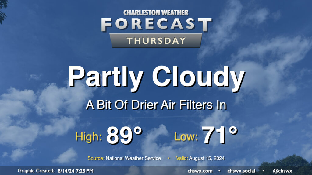
High pressure wedging southward across the area has brought some cooler and drier air to the area this evening, with dewpoints falling into the mid-60s (it’s been a minute!). This will yield a fairly nice (but still warm) day on Thursday. We’ll start the day in the low 70s and warm to the upper 80s in the afternoon under partly cloudy to mostly sunny skies. With the lack of moisture and influence of high pressure, rain isn’t expected (and won’t be for a few days). Overall, not too shabby for mid-August!
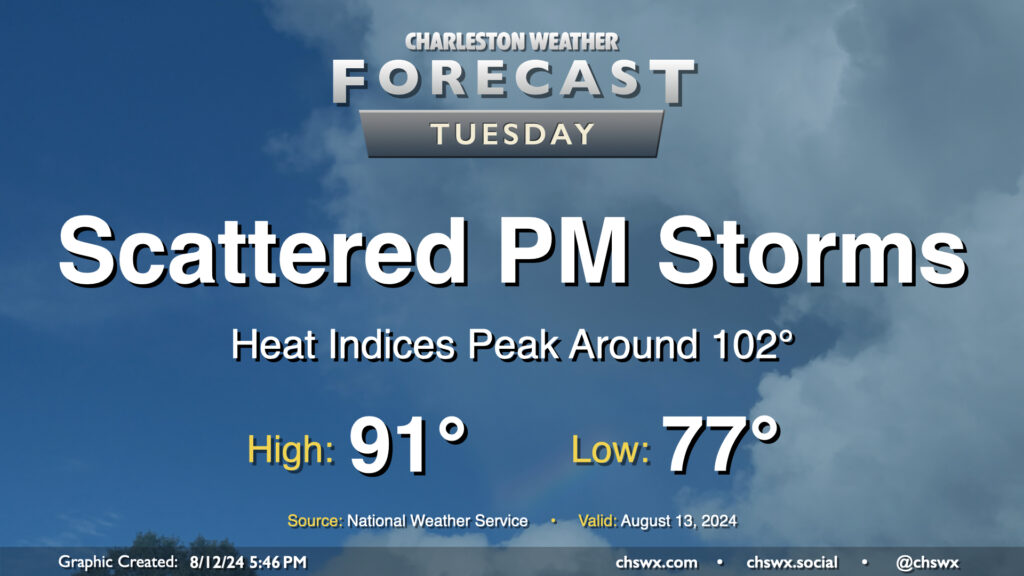
Tuesday’s forecast will continue to feature warm temperatures and afternoon thunderstorms as Berkeley and Charleston head back to school. We have another warm start ahead of us — generally expect lows in the upper 70s once again, followed by highs in the low 90s in the afternoon. This should run a couple degrees cooler with a little more onshore flow, but it’ll still be toasty with heat indices peaking around 102° before showers and storms fire. Once again, heavy downpours could cause localized flooding, especially near swollen rivers and streams and in urban areas, so stay alert for possible Flood Advisories.
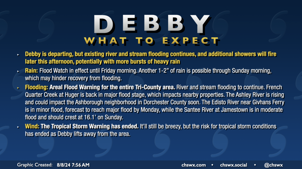
All Tropical Storm Warnings were dropped this morning as Debby, which made landfall around Bulls Bay at 2am, continues to lift north away from the area. The risk for flooding continues, especially near rivers, creeks, and streams. An Areal Flood Warning remains in effect across the entire Tri-County area through at least 2:45pm. Additional rain should develop courtesy of some wraparound moisture from Debby as we get into the heat of the day, which could inhibit recovery from flooding, so the warning continues. The Flood Watch continues until Friday morning as well.
Temperatures today will run in the upper 80s, closer to normal after a record cool high temperature of 80° on Wednesday. We’ve seen some peeks of sun and blue sky this morning and should hopefully see a bit more of that just for our spirits’ sake. The sun will make a more complete comeback for Friday and the weekend.
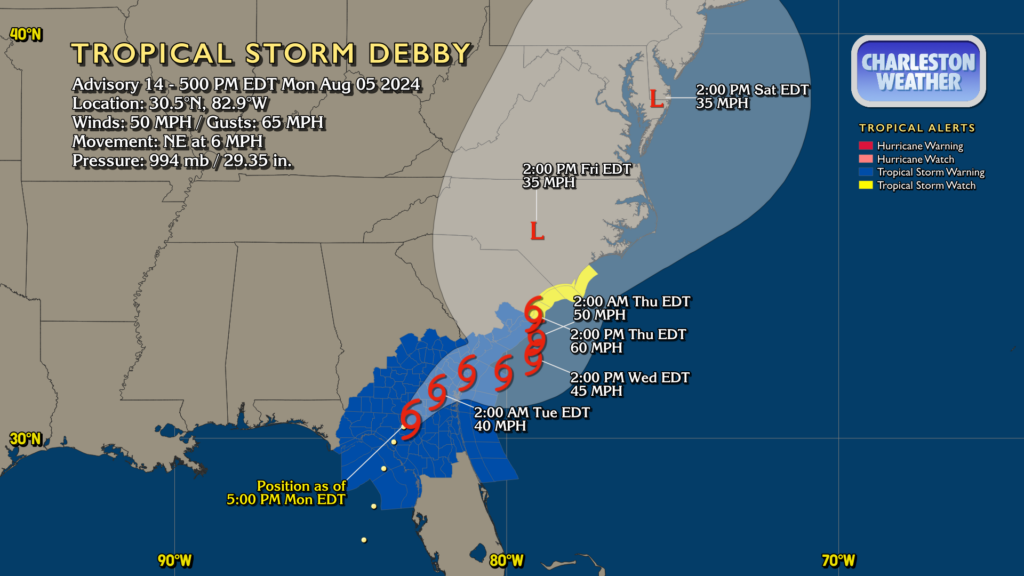
Debby made landfall this morning along the Big Bend of Florida as a Category 1 hurricane. It’s since fallen back to being a tropical storm with max winds now at 50 MPH, but its forward speed has been slowing as steering currents collapse around it. This is setting the stage for the well-advertised prolonged deluge and flash flood threat that will unfold particularly over the next couple days.
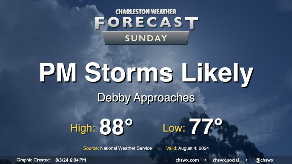
Tropical Storm Debby, newly christened as of 5PM, will march up the Florida coast on Sunday, strengthening as it goes over 90°+ degree water in the Gulf of Mexico. Here at home, moisture will begin to increase ahead of the storm, and that should lead to scattered to numerous showers and thunderstorms in the afternoon and evening hours. Expect balmy lows in the upper 70s to yield to highs in the upper 80s in the afternoon as the flow begins to turn more onshore and showers and thunderstorms become more numerous. A strong storm or two can’t be ruled out, as is normally the case this time of year.