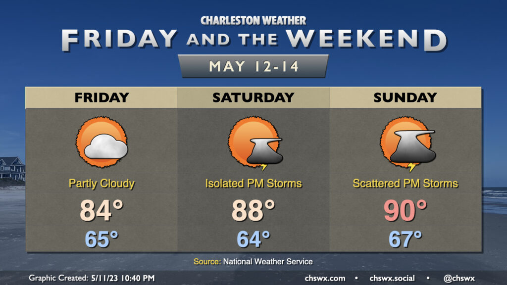
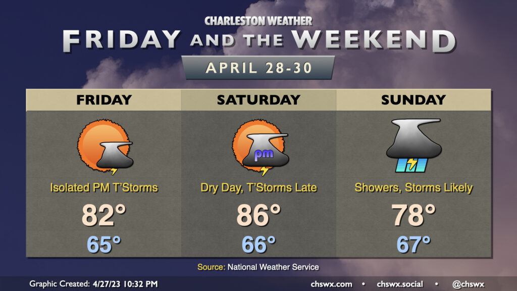
We’re turning warmer to close out the work week and head into the weekend as high pressure shifts offshore and winds go more southerly. Friday tops out around 84° with a low in the mid-60s, while Saturday heads to the upper 80s and Sunday tops out near 90° as ridging builds in aloft.
We look to stay rain-free Friday, but a storm or two will be possible Saturday afternoon with slightly better storm chances Sunday afternoon into the evening hours. Some spots may see some brief downpours and some gusty winds, but it’s not looking terribly favorable for organized severe weather. That being said, storm motions will be coastward, and so if you head to the beaches or are otherwise out and about, keep an eye to the sky and be ready to head indoors if weather conditions take a turn. Remember, when thunder roars, go indoors!
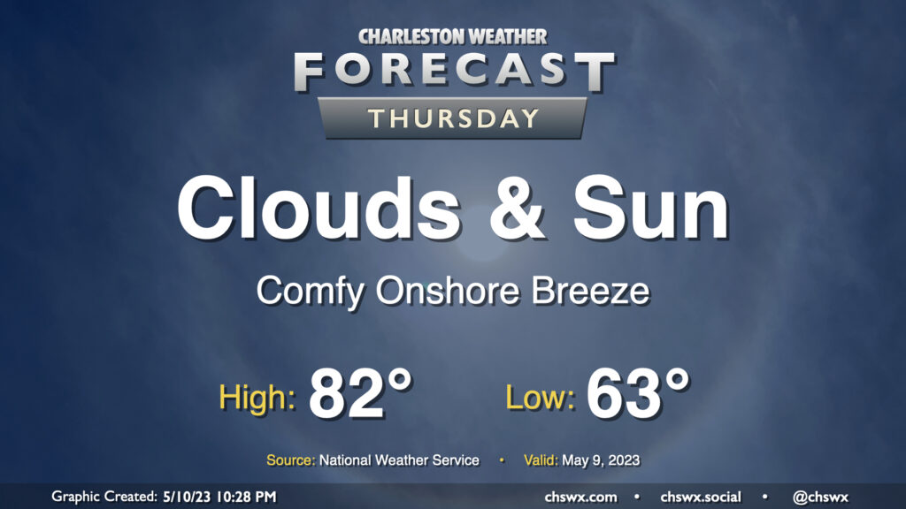
Not much to write home about weather-wise on Thursday. We’ll see a mix of clouds and sun throughout the day and continued comfortable temperatures; lows start in the low 60s with highs topping out in the low 80s in the afternoon, with an easterly breeze and the expected broken cloud cover to be a contributor to those temperatures. All in all, no hazards are expected and it should be a fine day.
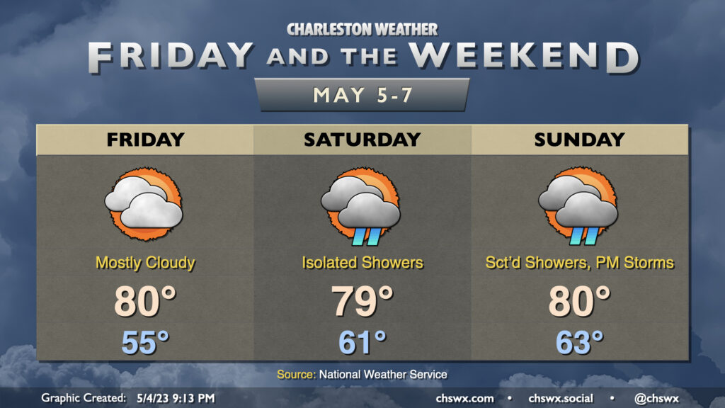
Allow me to revise the list of life’s inevitabilities as of 2023: Death, taxes, and shower chances over the weekend. A slow-moving front will be the latest culprit, keeping isolated to scattered showers on our mind each day this weekend. (It’s worth noting, though, that a total washout is not expected!)
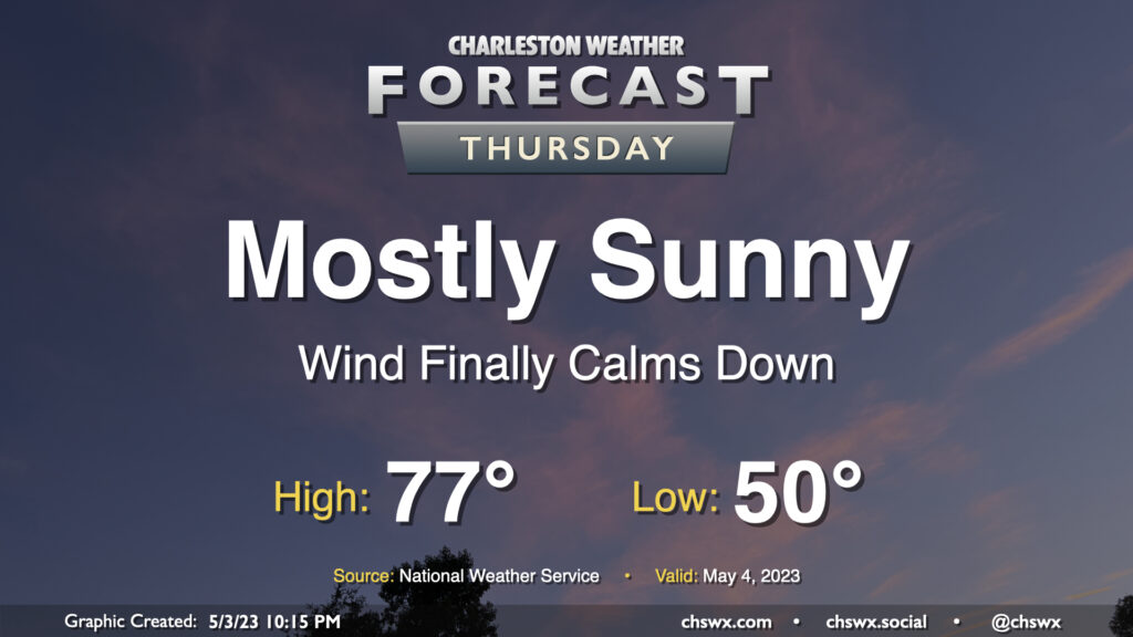
Thursday will represent the peak of our stretch of nice weather for one main reason: the pressure gradient that has kept our winds elevated for several days will finally have relaxed, bringing winds down to a light breeze during the day. Otherwise, it’s a carbon copy of Wednesday: Lows around 50°, with highs in the mid-70s in the afternoon under mostly sunny skies. I hope you can take advantage!
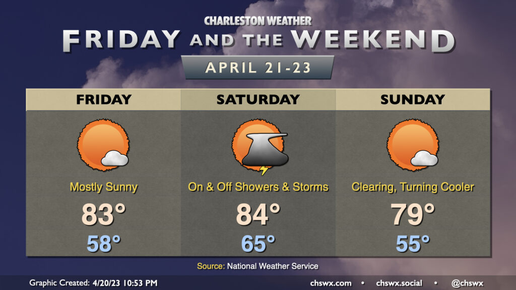
So one thing you’ll notice out of the gate with Friday’s forecast is that it looks a lot less stormy. This is due to the batch of rain pushing through as of this writing on Thursday evening; once this is through in the early morning, we’ll be in a lull in the more widespread activity, it looks like. Isolated to scattered thunderstorms remain possible, though, particularly further inland. The atmosphere will be primed for some sporadic severe weather if storms can fire given sufficient instability and shear, with damaging winds and hail the main concerns. However, the if in the previous sentence is pretty loaded — some models show very little if any rain during the day Friday. We’ll want to wait and see, and I’ll encourage you to stay weather-aware in case storms threaten, but overall the forecast looks a lot less soggy than it has for a good bit of the week. Highs will top out in the low 80s after starting the day in the mid-60s.
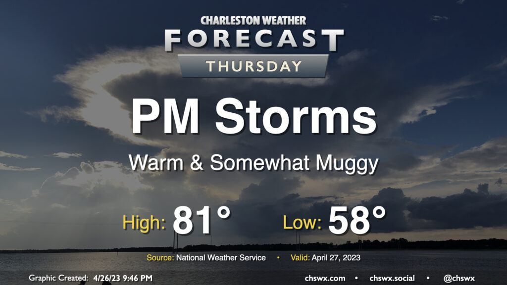
We should get a fair bit of Thursday in rain-free, but changes will be coming later in the day as low pressure to the west approaches the area. We start one more morning in the upper 50s before a warm front gradually lifts through the area throughout the day, which will bring dewpoints up in the afternoon and put a little mugginess in the air. A shower or storm along the seabreeze in the afternoon and early evening can’t be totally discounted, but the bulk of the rain arrives after dark with the aforementioned low pressure and will be around for much of the overnight.
A cold front will move through this weekend, knocking temperatures down a peg but also bringing showers and a few thunderstorms into the area on Saturday.
One more predominantly sunny day is in store for Thursday as stacked high pressure remains in place across the Carolinas. We’ll start the day in the mid-50s, generally around normal for April 20, before warming into the mid-to-upper 80s in the afternoon, which is ten degrees above normal. Unfettered sunshine is expected once again, with very little, if any, in the way of cloud cover. It’ll be another great day to get outside for lunch or even a nice golden-hour dinner.
We’ll see some showers at times over the next few days, but there’s going to be ample amounts of good weather, too — crucial for this High Water Festival weekend.
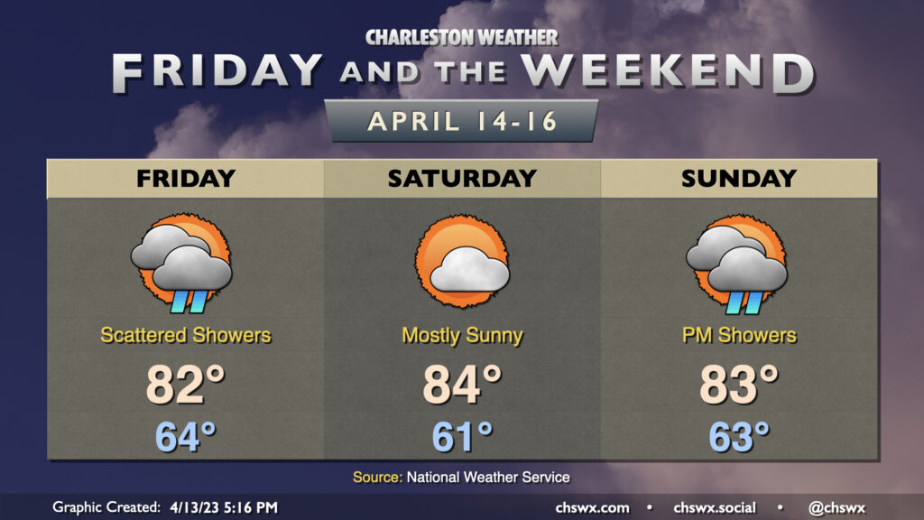
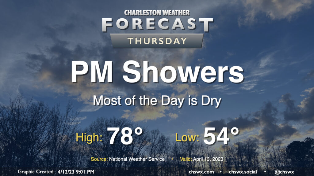
Showers return to the forecast later Thursday as high pressure slips offshore ahead of a low advancing northward out of the Gulf. We start dry and should get a good bit of the day in without rain, though. After starting in the mid-50s, highs will top out in the upper 70s as cloud cover increases ahead of showers. Expect the onset of rain roughly mid to late afternoon into the evening hours. It’ll be off and on, but could be briefly heavy at times. A little thunder can’t be ruled out, either. The best rain chances come after dark and persist into Friday.