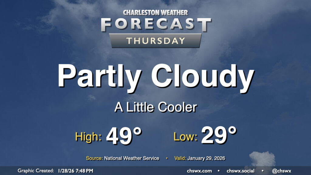
Another chilly day lies ahead for Thursday as a dry cold front slides southward across the area, reinforcing the cooler airmass that’s been in place for much of this past week so far. Temperatures will start in the upper 20s to around 30° for yet another subfreezing start this week. We’ll see some clouds at times, with greater cloud cover expected as we get into the evening, but otherwise there should be plenty of sunshine. Despite the sun, though, the reinforcing shot of cooler air keeps highs pinned to the upper 40s to around 50°.
After a high of 72° on Thursday, we’ll turn progressively cooler heading into the weekend as a large storm system affects much of the southern and Mid-Atlantic states over the next few days. Fortunately, the risk for accumulating ice continues to decrease into oblivion for much of the Charleston metro area.
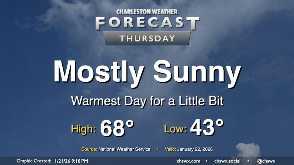
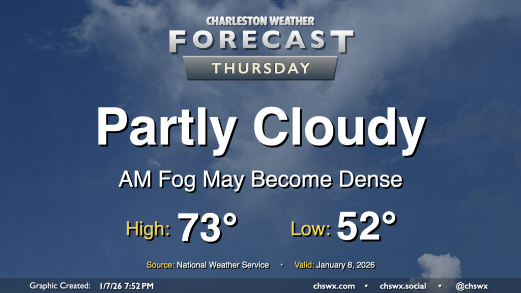
Thursday looks like the nicest day we’ll have for a little while before the well-advertised winter storm system impacts the South, followed by a round of Arctic air to kick off next week. Temperatures Wednesday start in the low to mid-40s — a marked increase from the low of 26° at the airport this morning — before warming to the upper 60s to perhaps even around 70° under mostly sunny skies. Enjoy this — as mentioned, things will start getting stormy and chilly by Saturday.
A very cold night is on tap tonight as high pressure settles in across the area, bringing winds down but also helping to create ideal radiational cooling conditions that will send lows to the low 20s across much of the metro by Friday morning, with 20s even reaching the beaches. Further inland, we could see temperatures dip into the upper teens. A Cold Weather Advisory is in effect for Berkeley and Dorchester counties where the most chilly conditions are expected. This’ll be pipe-busting cold so make sure you’ve got a faucet dripping, plants are covered, pets are inside and warm, and the vulnerable people in your life are accounted for and safe.
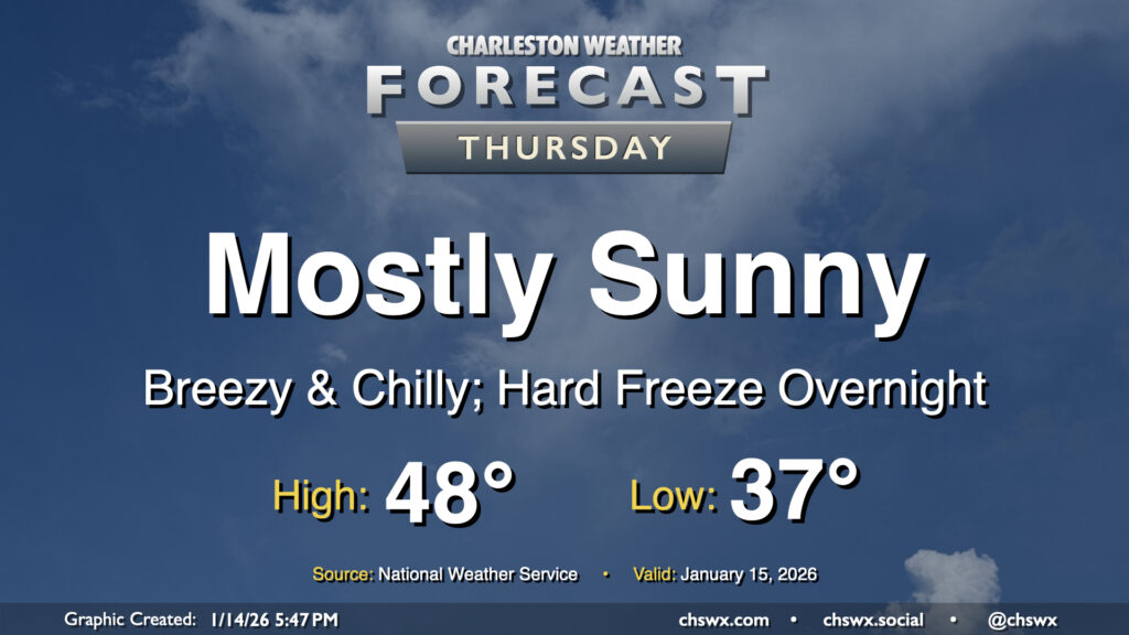
A cold front will come through early Thursday, ushering in another round of very cold and dry air to the area which may elevate fire danger during the day. We’ll start the day in the mid-to-upper 30s with a few clouds around. Those clouds will largely scour out as the drier air punches in, and it will punch in — expect winds around 10-15 MPH with higher gusts at times. The influx of cold air will limit highs to the upper 40s despite full sunshine, and with the wind, it’ll feel even cooler than that. This will lead to a hard freeze overnight Thursday into Friday morning, so you’ll want to make sure that pets, plants, pipes, and people are protected as temperatures plummet into the low 20s by Friday morning.
Another round of fog is expected overnight into Friday morning as abnormally warm temperatures continue across the Lowcountry. Lows will fall into the mid-50s, reaching the dewpoint with relatively calm winds. Once again, be prepared for low visibility and delays due to fog as you commute Friday morning. Like Thursday, the fog should mix out by mid-morning, and from there, temperatures will head to the mid-to-upper 70s. We’ll challenge the record high of 78° set in 2012 with a mix of sun and clouds in the afternoon.
We may get another abnormally warm January day off to a foggy start across a good bit of the area as winds go calm and temperatures fall to right around their dewpoints in the low-to-mid-50s. It’s not a slam dunk that we’ll run into fog, but better to be ready for it and the associated commute delays that may come along with it.
If it develops, fog should eventually mix out by mid-morning as temperatures head into the low 70s once again under generally partly cloudy skies. It’ll be a much warmer-than-normal day — a normal January 8 should only see highs peaking around 60° — but at least the record of 81° set in 2005 will remain unchallenged.
I hope you and yours are having a nice and safe start to your 2026! We certainly have had a nice day of weather on Thursday to kick the new year off right, but the first storm system of the year won’t waste any time getting through the area on Saturday.
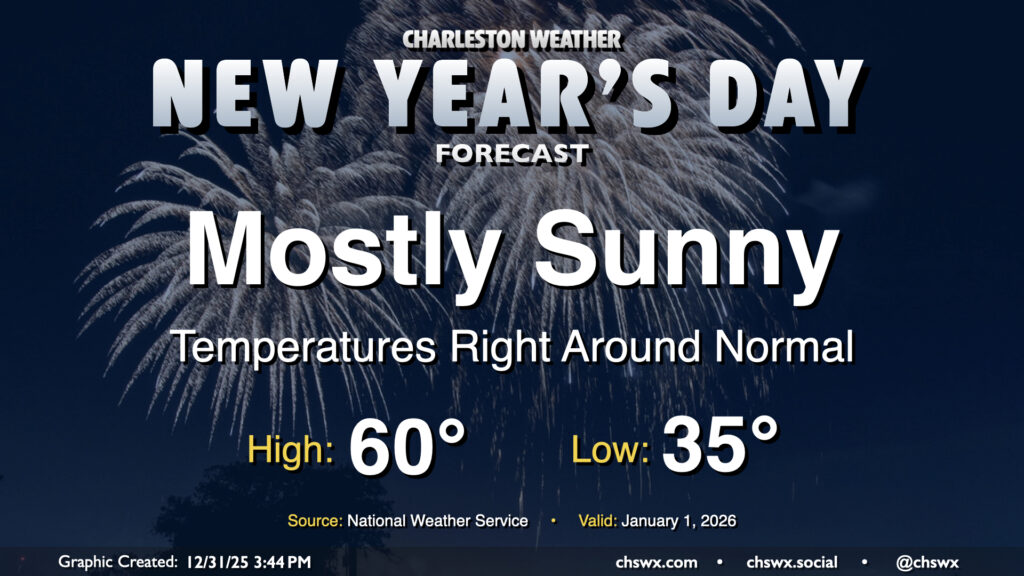
We’ll get 2026 off to a slightly chilly but seasonable start with surface high pressure in control. Temperatures will fall to the mid-30s by morning, with some freezing temperatures possible closer to I-95. With plenty of sunshine, though, temperatures will rebound right to where they should be for the beginning of the year, with highs peaking around 60° in the afternoon. It’ll be a bit breezy, especially in the morning, but those winds will slacken some as we head into the evening.
I hope everyone celebrating had a very Merry Christmas! It was certainly a warm one as the high reached 78° today, just two degrees off the record of 80° last set in 2015 and cementing itself ahead of Christmas 2016 for the second-warmest Christmas high temperature on record at the airport.
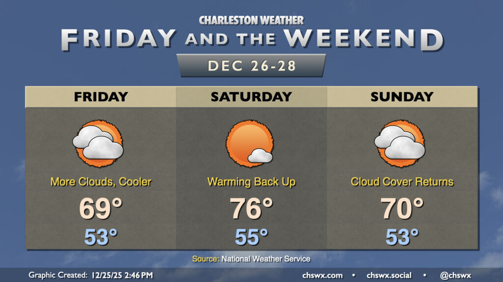
A backdoor cold front stalling nearby will drive more cloud cover into the area for Friday as well as a bit more in the way of onshore flow, which will make for a cooler day (though temperatures will remain above normal). Lows in the low-to-mid-50s will warm to the upper 60s to around 70°. Model guidance keeps the core of the cold air damming regime to the north of the area, but some spots further north in the Tri-County could see temperatures come in a little cooler than that depending on how far south the front penetrates.