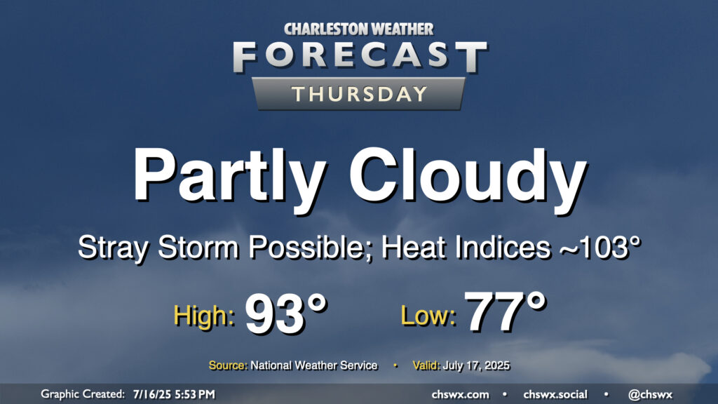
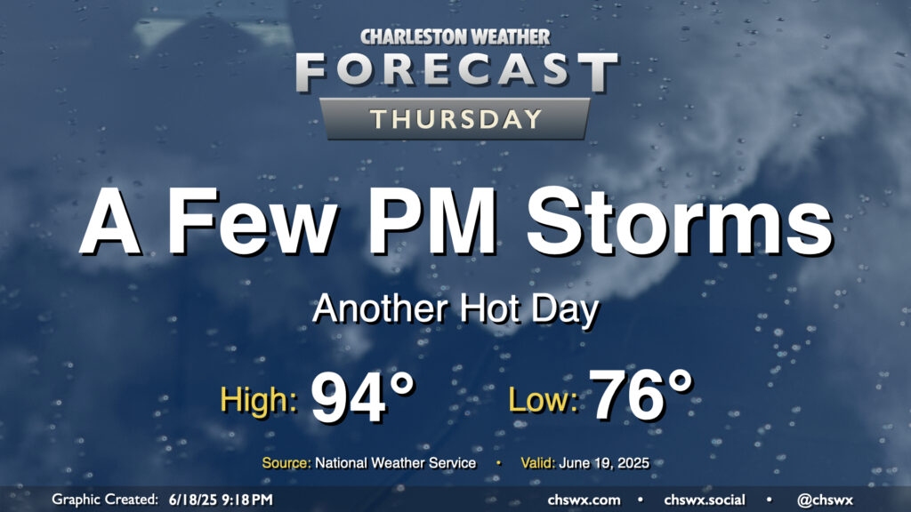
Storms will be more hit-or-miss on Thursday as high pressure aloft starts to rebuild, which will heat things up for the weekend. Temperatures will start in the mid-to-upper 70s, with lows possibly not getting below 80° at the beaches. We’ll warm to the low-to-mid-90s in the afternoon, and with limited storm coverage, heat indices should have no trouble getting into the low-to-mid-100s, especially post-seabreeze.
We should see more thunderstorms on Friday as mid-level energy continues to affect the area for one more day. High pressure then ridges in aloft for the weekend, warming temperatures up and taking storm chances down a notch.
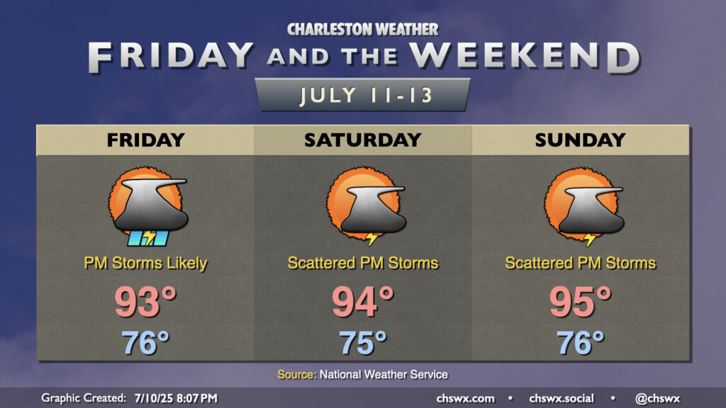
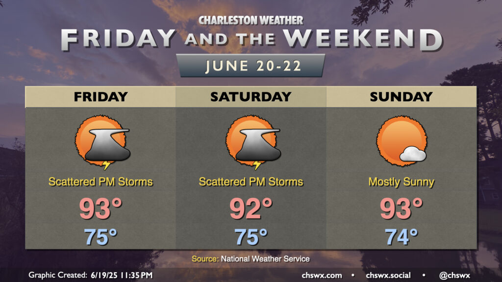
A fairly standard summer setup will take shape for Friday and the weekend as high pressure in the Atlantic ridges westward across the area, keeping temperatures warm and humid with daily storm chances. We can generally expect temperatures to start in the mid-70s each morning, with temperatures warming to the low to mid-90s each afternoon as our run of 90° days dating back to June 14 continues. Dewpoints ahead of the seabreeze will mix out with some drier air aloft to keep heat indices from getting too far out of hand, with apparent temperatures running just 3 or 4° warmer than air temperatures. Still, if you have vulnerability to the heat, be mindful of too much strenuous activity during the afternoons.
We should see isolated to scattered showers and thunderstorms fire along and ahead of the seabreeze each afternoon. The risk for severe weather is very low, but there’s always the risk for a storm or two to briefly turn strong to severe especially where thunderstorm outflow boundaries collide. Remember, all thunderstorms are dangerous because of the lightning they produce. When thunder roars, go indoors!
The high heat of the past couple days — we hit 98° again on Wednesday, just one degree off the record high — will let up on Thursday as high pressure aloft continues to weaken. Don’t misunderstand: it’ll still be plenty hot, but not to the Advisory-level thresholds we’ve hit recently. After a start in the mid-70s, likely in the wake of thunderstorms that are expected late tonight into early Thursday morning, temperatures in the afternoon warm to the low 90s. Dewpoints will mix down to around 70°, so heat indices should stay relatively tame, with a brief spike into the upper 90s possible as the seabreeze pushes inland. A few showers and thunderstorms could pop on the seabreeze, as is often the case this time of year, but nothing out-of-bounds is expected.
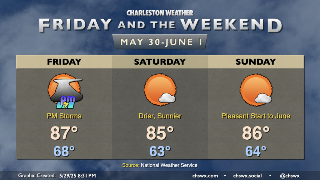
As we reach the summer solstice late Friday night (10:20 PM, to be exact), the weather will be seasonally appropriate. We can generally expect temperature in the low to mid-90s each afternoon after muggy starts in the mid-70s. Showers and thunderstorms will be possible particularly Friday and Saturday afternoons along and ahead of the seabreeze, though updrafts will struggle against high pressure building in aloft. In fact, we should generally see a lid on things for Sunday, making for a mostly sunny day. Heat indices will still run in the upper 90s to around 100°, so be sure you’re getting plenty of water and rest if you’re working or playing outside.
More heat and humidity are on tap for Thursday, but with a slightly better chance of storms in the afternoon especially as a front gets closer to the area. We’ll start the day in the mid-70s once again, warming back to the mid-90s in the afternoon. We’ll be keeping an eye on a line of thunderstorms to our northwest, which could help induce some stronger storms in the metro later in the afternoon through the evening hours. Damaging wind gusts would be the primary concern in the strongest storms, though the risk for severe weather is generally low (but not zero) across the area.
Active weather continues to be in the cards as we head into Friday and the weekend as we continue to sit on the western periphery of high pressure, allowing bits of energy aloft to ripple through at times to instigate more showers and thunderstorms. We’ll also have periods to dry out, too, with the sun getting through and helping temperatures build into the 90s by Sunday.
After a quiet start to the day, another round of afternoon showers and thunderstorms are expected to develop and move across parts of the Tri-County on Thursday as we remain in an unsettled pattern. Alas, we will keep this going into the weekend, too.
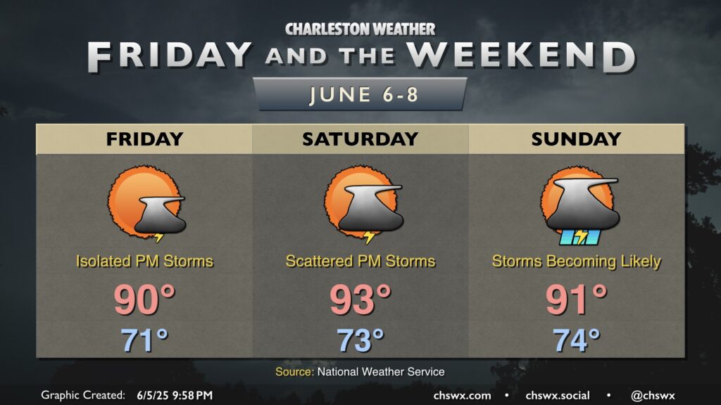
The good news for Friday is that storm chances trend downward, with just some isolated storms on the seabreeze expected in the afternoon. We could stand to dry out a bit, especially after the deluge in Summerville on Thursday, and Friday gives some of us an opportunity to do exactly that. It’ll be very summerlike, though, with highs around 90° after a low 70s start, and low-70s dewpoints will make it feel more like the mid-to-upper 90s.
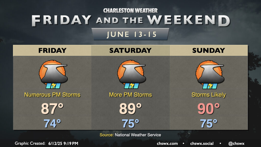
A respite from the rain is coming just in time for the weekend (and it’ll be a beaut), but we’ve got one more day with storms — and the risk for a few severe storms, at that — coming up with a cold front on Friday.