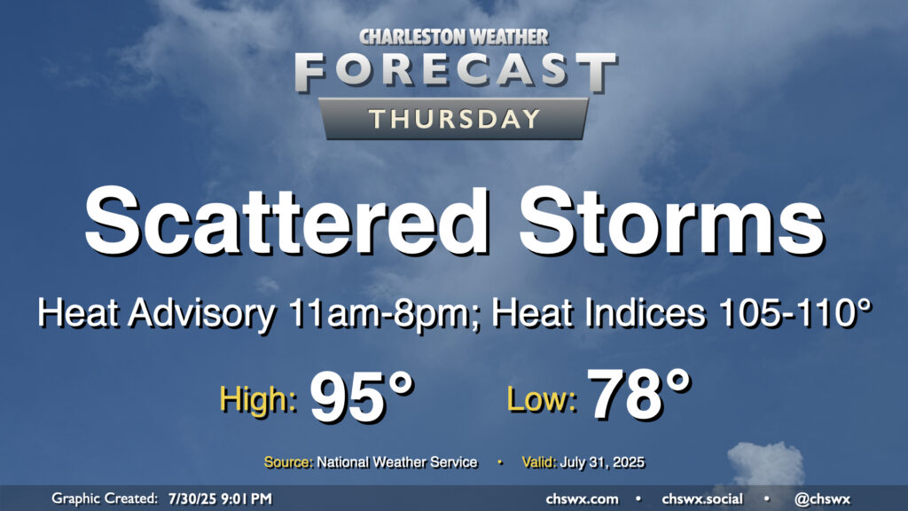
The heat wave rolls on into Thursday as we continue to sit between low pressure to the west and high pressure over the Atlantic, funneling warm and humid air into the area. We once again look to get off to a very warm and humid start with lows topping out in the upper 70s inland to low 80s near the coast. Temperatures will then warm to the low-to-mid-90s in the afternoon before showers and thunderstorms kick off, cooling some spots down. Daytime heating combined with mid-to-upper-70s dewpoints will drive heat indices to around 108-112° inland and approaching 116° closer to the coast. This has prompted an Extreme Heat Warning for Charleston and southern portions of Berkeley County (Hanahan, Daniel Island) along with an expansion of the heat advisory inland to the rest of Berkeley and Dorchester counties from 11am-8pm. Get plenty of hydration and be sure to take frequent breaks indoors or in the shade if you are working outdoors during the heat of the day!
Expect showers and storms to kick off in the noon-2pm timeframe. Slow-moving storms are again expected, with the potential for training of rainfall over some of the same areas, yielding some heavy rain and perhaps a few more flood advisories. Lightning will also be prevalent once again, so be ready to head inside if thunderstorms approach. It won’t rain all day at any one spot, though.
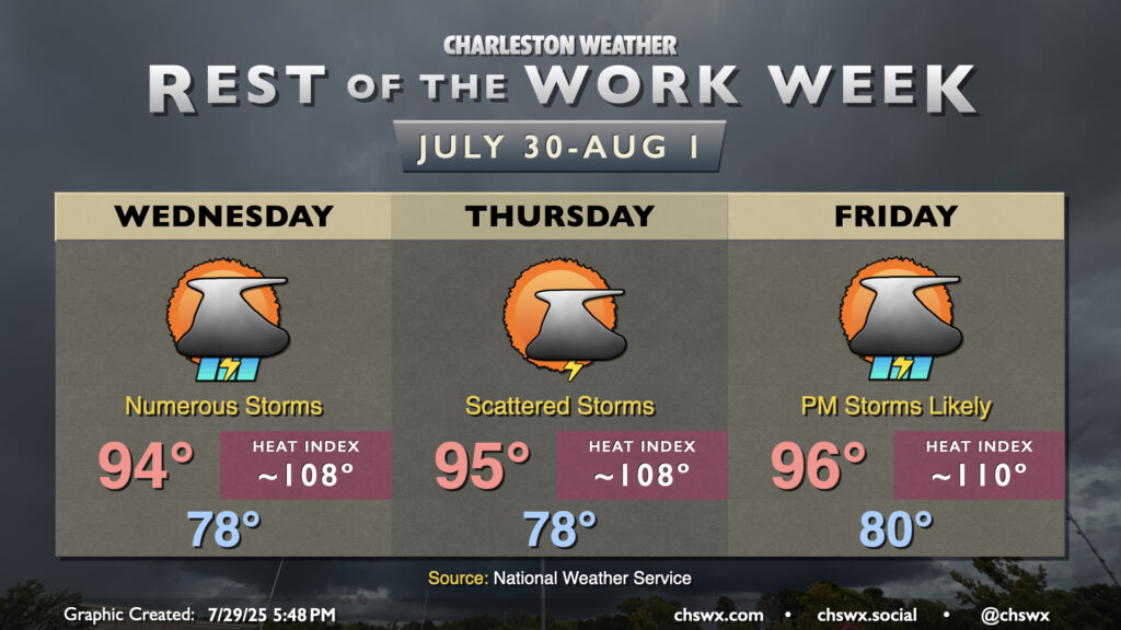
Our late-July heat wave continues for the rest of the work week, but thankfully with some afternoon and evening thunderstorms to help take the edge off a bit.
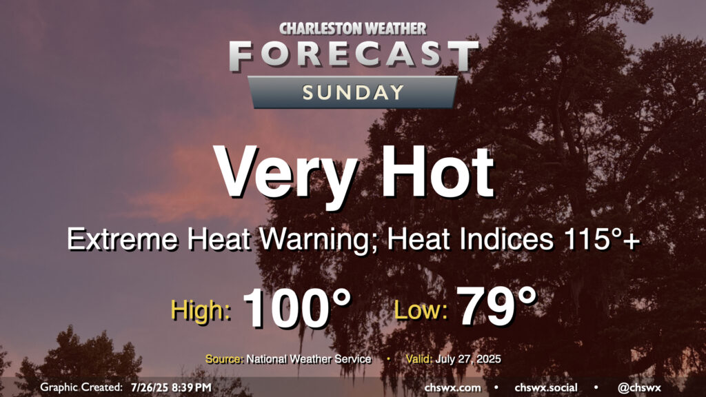
Sunday’s going to be a very hot day across the area, with extreme heat expected across the Charleston metro especially as we get into the afternoon. The overnight and morning really won’t offer much relief, with air temperatures in the upper 70s to low 80s for lows expected. This could keep heat indices over 90° especially closer to the coast, including downtown, for much of the night. Once the sun comes up, we’ll warm up very quickly; heat indices should be over 100° by 10-11am. Air temperatures should peak near 100° in the afternoon, and if we reach the triple digits at the airport, it’ll at least tie a record high (100°, set in 2005) as well as the first time since May 27, 2019 that the high temperature reached the century mark in Charleston. Mix in humidity and it will feel like 115° and perhaps even hotter, especially in the wake of the seabreeze as dewpoints surge behind it. The strong ridge of high pressure will put the kibosh on any thunderstorm activity, so don’t look for any relief from Mother Nature on Sunday.
Heat indices over 110° are dangerous to everyone. Make sure you’re getting any exercise in during the early hours, get plenty of fluids if you must be outdoors, and take frequent breaks.
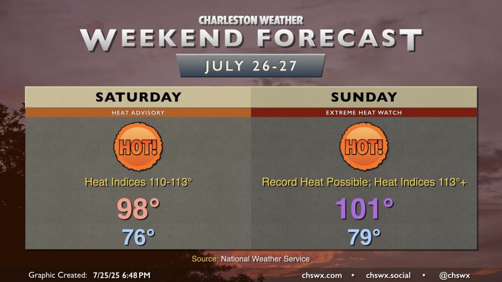
This is one of those weekends where you probably want to just stay in a nice, cool place as a heat wave begins to ramp up across the Lowcountry, with the potential for several record highs and record warm low temperatures to occur starting Saturday through much of next week.