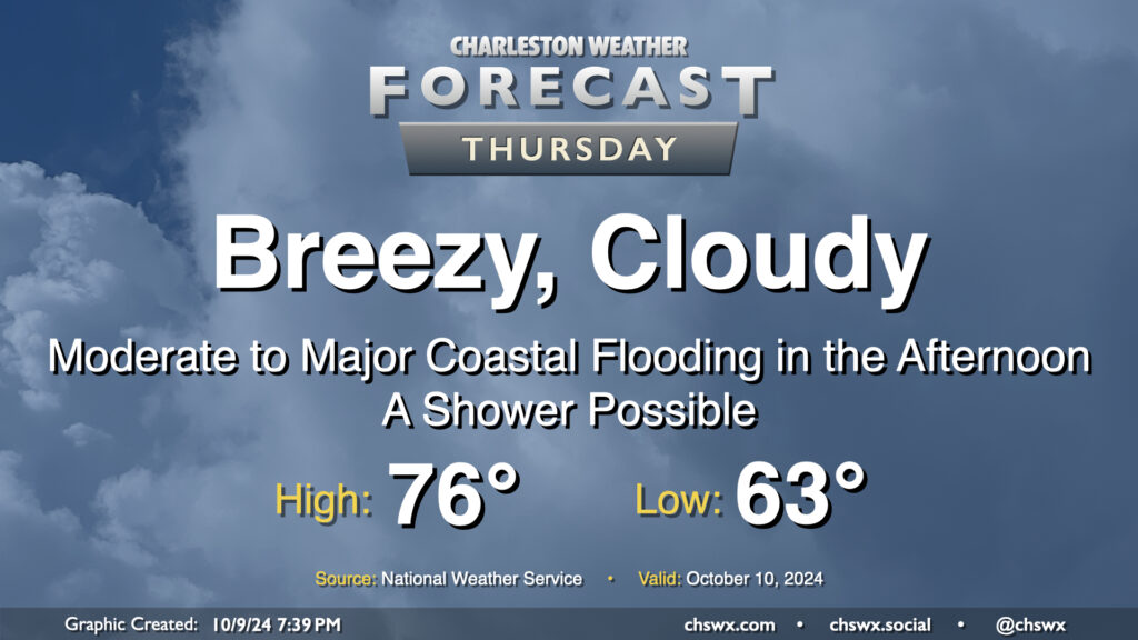
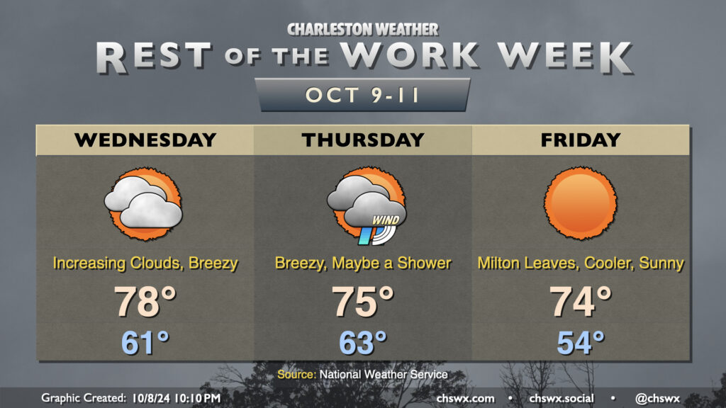
Our brush with Milton arrives on Thursday. The Tropical Storm Watch was dropped as tropical storm conditions are not expected on land (though a Tropical Storm Warning is in effect for the coastal waters). However, that doesn’t change the forecast: It’ll still be a breezy day, with a Wind Advisory in effect for the area from 6 AM to 8 PM as the gradient between high pressure to the north and Milton to the south pinches and drives gusts upwards of 40 MPH across the area. Moderate to major coastal flooding is also expected during the afternoon, with some salt water flooding possibly persisting into early evening depending on how high the tidal departure ends up being. Right now, moderate flooding is forecast as the harbor should peak at 7.8′ MLLW with high tide just before 2 PM. This will close roads in downtown Charleston and parts of Mt. Pleasant, especially around Long Point Road. Be ready to reroute in case you encounter a flooded road.
The rain threat, however, is minimal. We may see a few showers sneak in from time to time, but we will miss out on Milton’s rainfall. In fact, we can expect skies to start to clear as we get further into the afternoon and evening. Temperatures will start in the low-to-mid-60s, warming to the mid-70s in the afternoon.
Clouds will increase on Wednesday as Hurricane Milton draws closer to landfall in Florida. We’ll see a decent northeasterly breeze during the day, but nothing unmanageable, and we’ll stay out of the rain, too. The day starts on a fairly cool note with lows in the low 60s, and we’ll warm to the upper 70s in the afternoon, tempered by the northeasterly winds and the increasing cloud cover. There will be a chance for some minor coastal flooding a couple hours around the 12:41 PM high tide, and a Coastal Flood Advisory is possible.
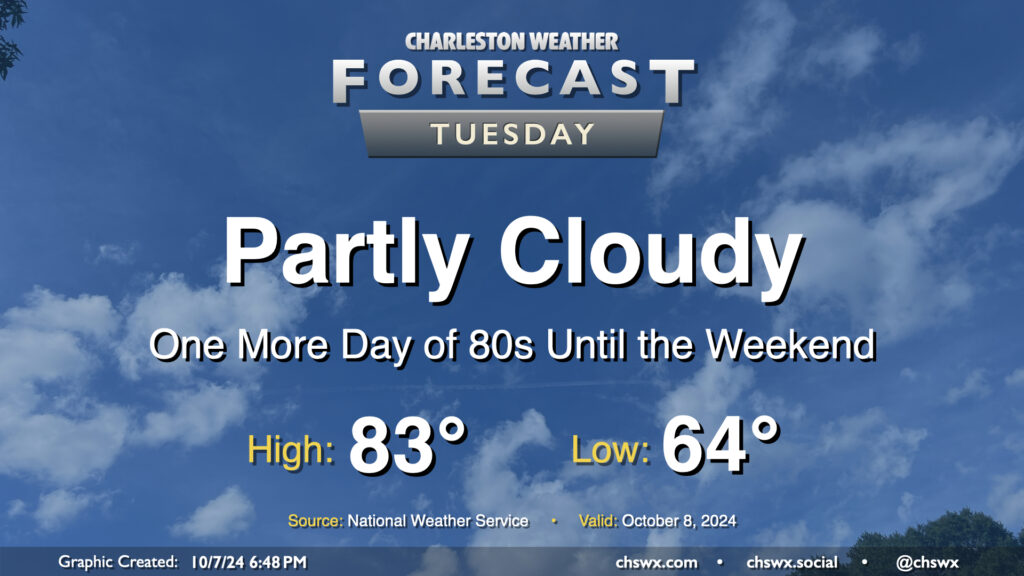
Quiet and warm weather continues Tuesday as we continue to monitor Hurricane Milton in the Gulf of Mexico for possible peripheral impacts on the Lowcountry as we get into Wednesday night and Thursday. Expect a comfortable start in the mid-60s on Tuesday, with temperatures warming to the low-to-mid-80s in the afternoon under partly cloudy skies (though clouds will be increasing as the day goes on). Northeast winds will generally run 10-15 MPH across the metro.
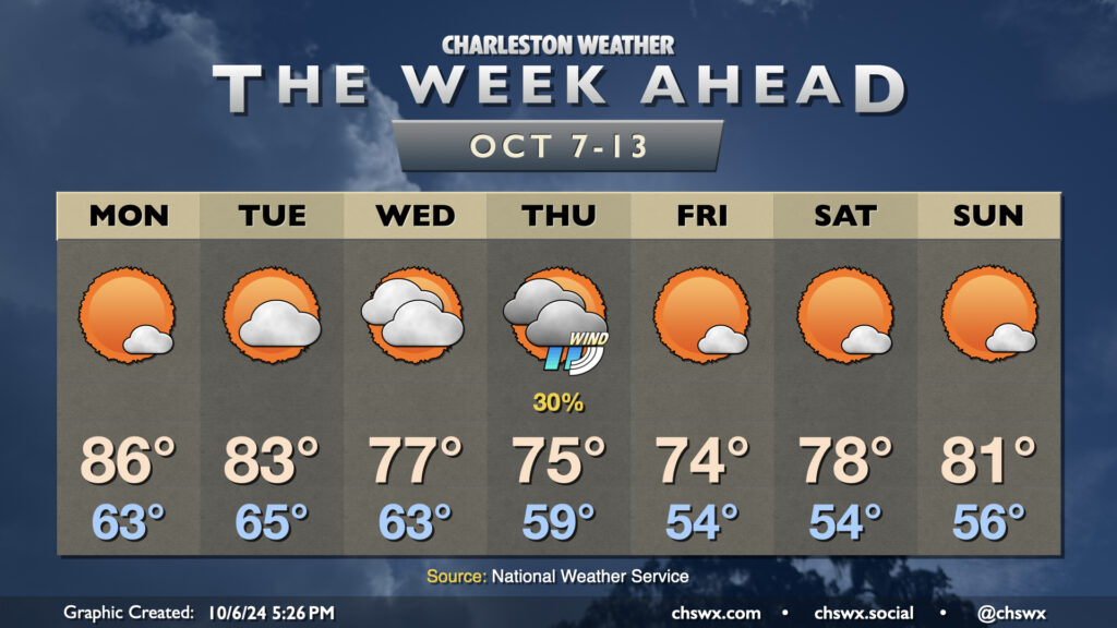
A cold front brings a shot of Fall to the area as we get into the meat of the new week with a possible brief appearance by Hurricane Milton as it departs into the Atlantic and turns extratropical.
Monday will be the warmest day of the week ahead of the aforementioned cold front. We’ll start the day in the low to mid-60s, which is right around where we should be at this point in the year. Temperatures will warm to the mid-80s in the afternoon under mostly sunny skies.
The front gets through Tuesday morning. We’ll start Tuesday in the mid-60s, but will only warm to the low 80s in the afternoon with a bit more in the way of cloud cover as the front stalls out to our south. Cloud cover and northeasterly winds increase Wednesday as Milton draws closer. This will keep highs only in the mid-to-upper 70s in the afternoon.
On the current forecast track, we can expect peripheral effects from Milton starting Wednesday night and peaking on Thursday. Showers will be possible near the coast, but the main concerns will be gusty winds as the gradient pinches between Milton to the south and high pressure to the north, rough surf and rip currents, maybe some beach erosion, and coastal flooding, which may be significant come Thursday. It’s too early to know the extent of those impacts, but it’ll be worth watching for travel troubles downtown around times of high tide.
The good news is that Milton departs quickly, and the weekend looks excellent, with the first solid stretch of lows in the 50s of the season expected through Sunday. Temperatures warm from the mid-70s on Friday to the low 80s on Sunday with plenty of sunshine expected.