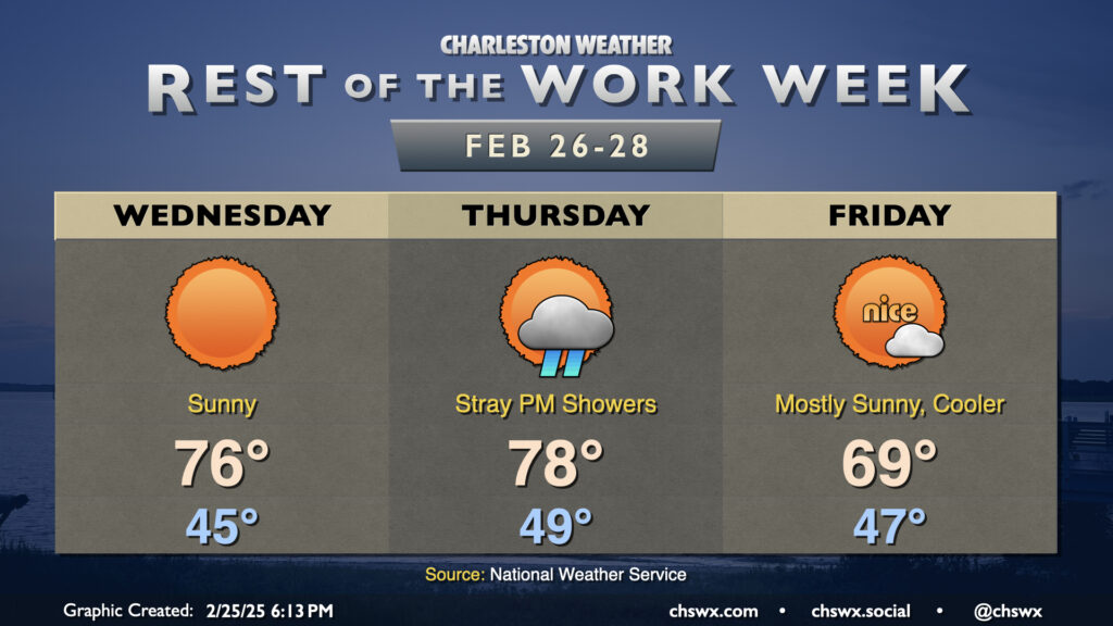
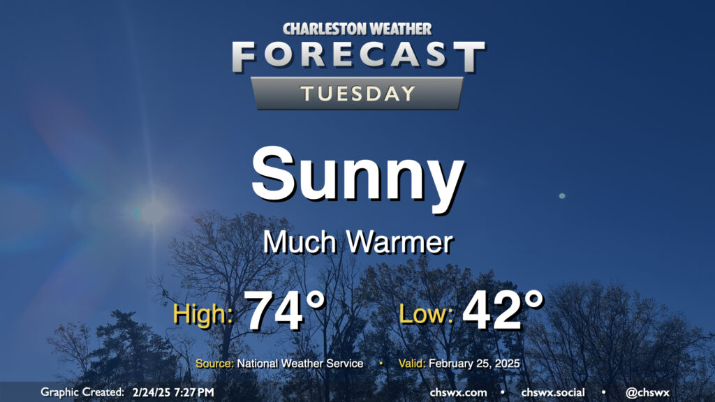
After hitting 76° on Tuesday — 10° above normal, but still 10° below a record — we’re back to the mid-70s on Wednesday with more sunshine expected. Once again, we’ll start the day in the mid-40s, which is close to normal for February 26, but the forecast high of 76° will once again run 10° above normal.
A cloudy and cool Monday will give way to a much sunnier and warmer Tuesday. After starting in the low 40s, expect highs to peak in the mid-70s in the afternoon, several degrees warmer than the 68° we peaked at on Monday. This is well above normal for the end of February; the normal high for February 25 is 66°.
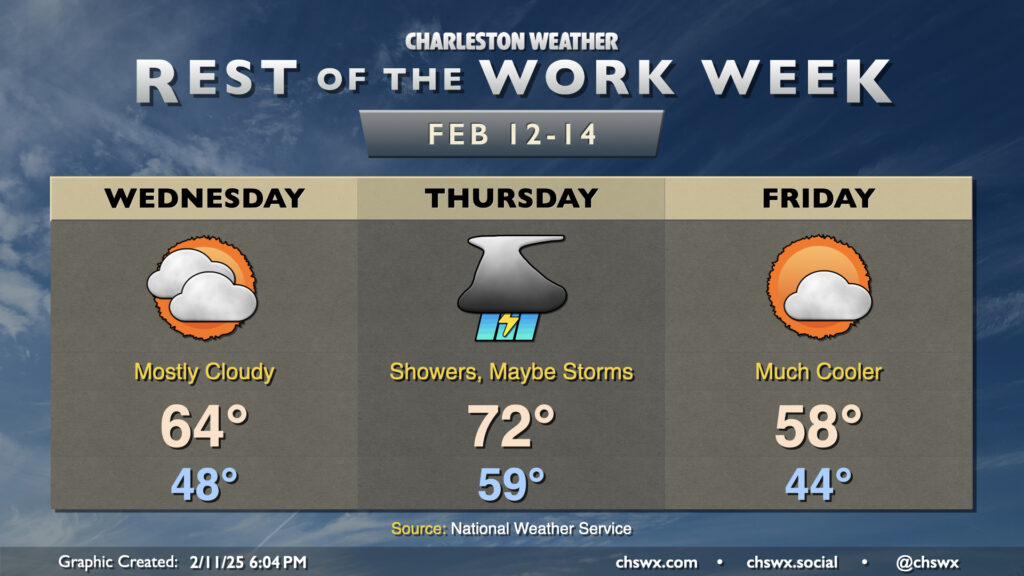
Unsettled weather is expected on Wednesday as a potent storm system brings us a good bit of much-needed rain, particularly in the afternoon into the evening. Lows start in the mid-40s, warming just to the mid-50s in the afternoon owing to the rain-cooled state of play. If you have travels taking you northward into the Midlands and beyond, there’s a risk for some winter weather as well, especially getting into NC and VA where ice and snow will be the rule. There will be too much warm air in our neck of the woods for any winter weather, and I suspect that is probably okay with many of you!
The temperature rollercoaster takes another upswing Wednesday and Thursday before dipping again Friday as a series of fronts affect the area.
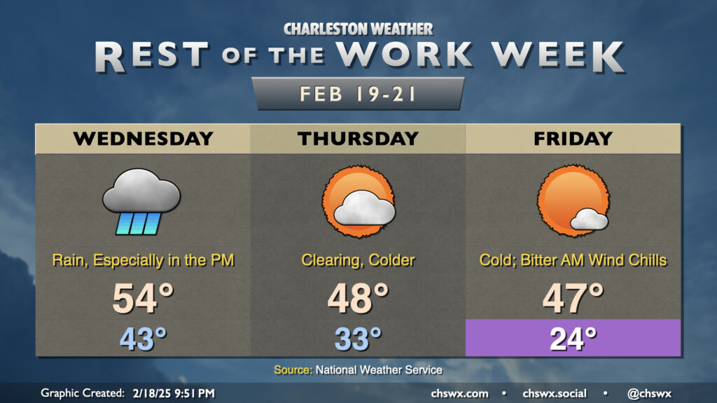
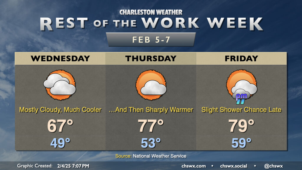
Astute @chswx readers will note that Wednesday’s forecast high is about 10° cooler than the 74° that was advertised yesterday. High-resolution model guidance is strongly suggestive that the wedge front will take longer to move northward across the area as a warm front than previously thought. In fact, there’s some indications that it may stall out right across the Tri-County for a time, which certainly makes for a tricky temperature forecast. Right now, the going forecast is the mid-60s with mostly cloudy skies expected.
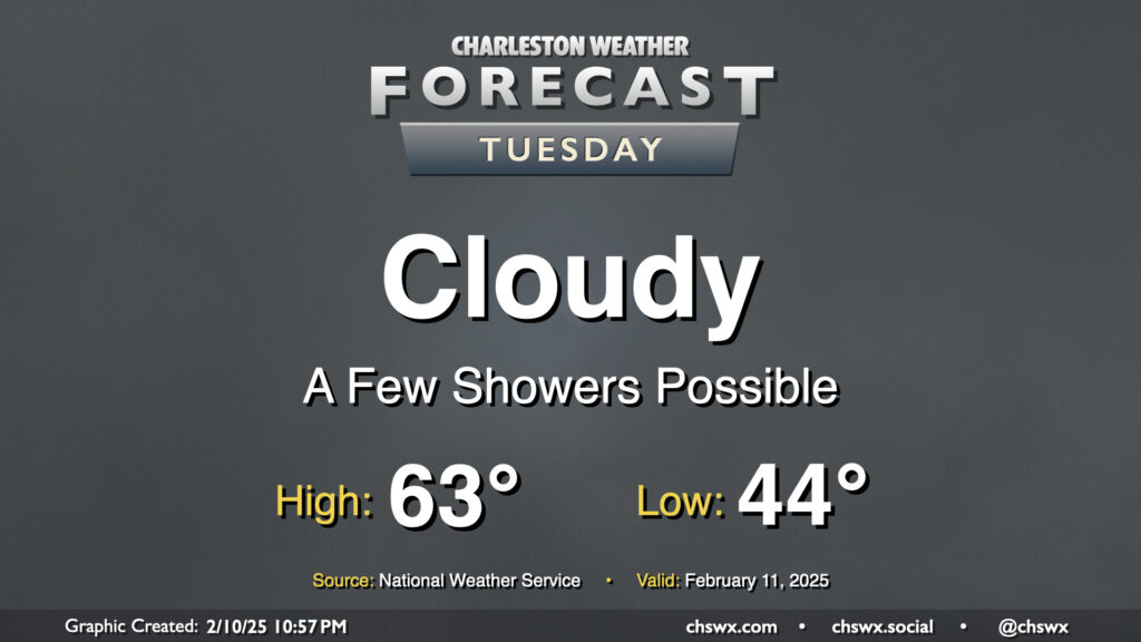
A wedge of cool high pressure hangs tough on Tuesday, bringing another gray and cool day to the area. Temperatures start in the mid-40s, warming to the low 60s in the afternoon — right around normal for this point in February. There’s going to be a risk for some showers from time to time, but an all-day rain isn’t expected.
We got very close to tying a record high at the airport on Tuesday as temperatures soared to the low 80s for the first time in 2025. Don’t let your hoodies walk too far, though — high pressure wedging southward will bring much cooler and cloudier conditions for Wednesday. After starting in the upper 40s to around 50°, expect temperatures to only head to the mid-to-upper 60s in the afternoon — a pretty stark contrast to getting into the 80s, that’s for sure.
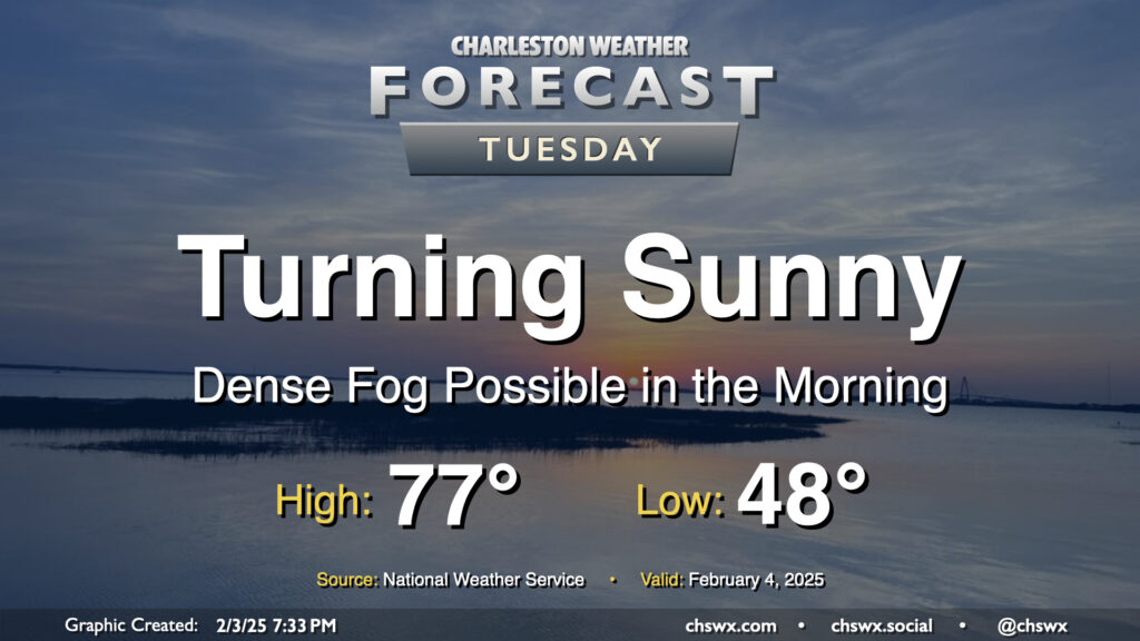
Sea fog will come ashore overnight and cause visibility issues especially near the Highway 17 corridor and points east. A Dense Fog Advisory will be in effect from 8PM Monday to 9AM Tuesday as a result. Use those low beams and allow plenty of space between you and the car in front of you.
Winds will go westerly and pick up after sunrise, which should escort the sea fog back offshore for the most part. This will allow temperatures to soar into the mid-to-upper 70s in the afternoon under mostly sunny skies. The exception will be at the immediate coast, where the seabreeze will help keep much cooler temperatures as well as continued sea fog in place. So, if you’re thinking “early February beach day,” just keep in mind that you’ll probably not be getting much sunshine.
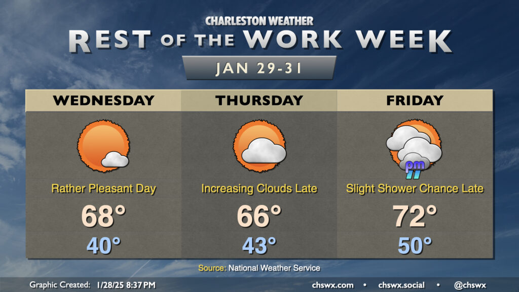
Warmer-than-normal temperatures will be the headline for the rest of the work week as high pressure ridges in a bit aloft. We’re still on track to see our first 70°+ reading of 2025 on Friday, too.
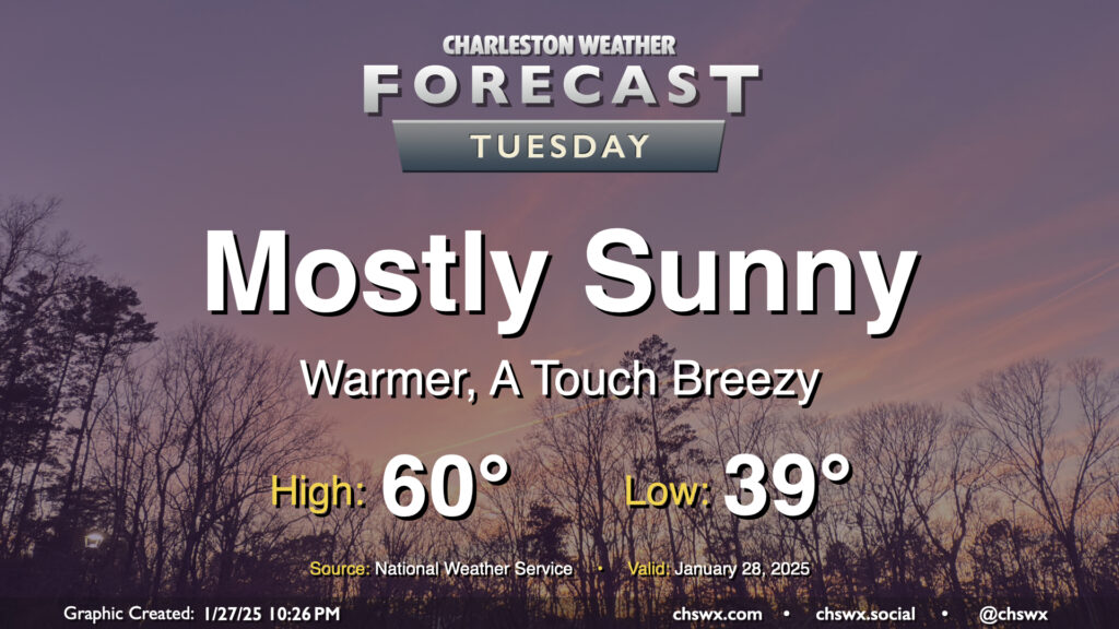
Tuesday will feel a lot better than Monday did as a front swings through with mostly a drier airmass, but not nearly as cold as the one we dealt with last week. We start the day in the upper 30s and warm to around 60° in the afternoon under mostly sunny skies. The black ice threat has ended, especially after Monday’s rain melted much of the rest of the snowpack and any lingering ice patches. If you have some snow left, it won’t be much longer, especially as we get into a warming trend this week.
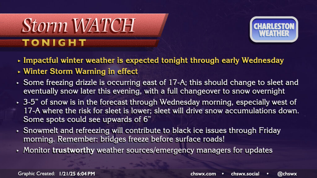
A Winter Storm Warning continues through noon Wednesday as winter weather is beginning to affect the area this evening. So far, we’ve seen some freezing drizzle primarily in the US-17 coastal corridor and points east, with trace accretion reported in places like James Island, Mt. Pleasant, and even at my home in West Ashley. Some bursts of sleet have been reported to be mixing in at times, particularly around Johns Island. Ice pellets have also been reported at the airport, and so we officially have a trace of snow so far today in North Charleston (sleet and snow are functionally considered the same accumulation in the historical climate record).
A special evening weather balloon release continued to indicate a pocket of warmer air aloft that is contributing to primarily freezing rain and sleet so far. The atmospheric column should continue to cool, though, and a changeover to all snow is still expected overnight into early Wednesday morning. By the time all is said and done, many spots should have between 3-5″ of snow. Areas closer to the coast may see accumulations impacted if more sleet falls, while others who stay in the snow longer could see upwards of 6″. This is a pretty stark upward revision from previous forecasts, but thus far all we’ve seen this storm do to our west is overperform. We’ll see how things shake out. Regardless of how much falls, we can still expect some tough road conditions tonight into Wednesday morning even after snow ends. The best course of action is to stay put tonight if at all possible, leaving roads open for essential and emergency workers.